
Mont-Saint-Jean (Côte-d'Or)
| Mont-Saint-Jean | ||
|---|---|---|
|
||
| region | Bourgogne-Franche-Comté | |
| Department | Côte-d'Or | |
| Arrondissement | Beaune | |
| Canton | Arnay-le-Duc | |
| Community association | Pouilly-en-Auxois Bligny-sur-Ouche | |
| Coordinates | 47 ° 18 ' N , 4 ° 24' E | |
| height | 355-577 m | |
| surface | 27.66 km 2 | |
| Residents | 241 (January 1, 2017) | |
| Population density | 9 inhabitants / km 2 | |
| Post Code | 21320 | |
| INSEE code | 21441 | |
 Town hall (Mairie) of Mont-Saint-Jean |
||

Mont-Saint-Jean is a French municipality with 241 inhabitants (as of January 1 2017) in the department of Côte-d'Or in the region Bourgogne Franche-Comté ; it belongs to the Arrondissement of Beaune and the canton of Arnay-le-Duc (until 2015: canton of Pouilly-en-Auxois ).
geography
Mont-Saint-Jean is about 48 kilometers west-southwest of Dijon . Mont-Saint-Jean is surrounded by the neighboring communities of Missery and Fontangy in the north and northwest, Charny in the north and northeast, Thorey-sous-Charny in the northeast, Chailly-sur-Armançon in the east and southeast, Marcilly-Ogny in the south and Thoisy- la-Berchère to the west and south-west.
Population development
| year | 1962 | 1968 | 1975 | 1982 | 1990 | 1999 | 2006 | 2013 |
| Residents | 352 | 335 | 283 | 271 | 270 | 262 | 256 | 254 |
| Source: Cassini and INSEE | ||||||||
Attractions
- Castle complex
- Saint-Jean-Baptiste church
- Saint-Pierre Priory in Glanot
- Manor house in Gincey, built around 1570
- Wash house

Castle complex
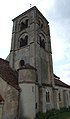
Saint-Jean-Baptiste church

Manor house in Gincey


Web links
Commons : Mont-Saint-Jean (Côte-d'Or) - Collection of images, videos and audio files