Pas d'Encel
| Pas d'Encel | |||
|---|---|---|---|
|
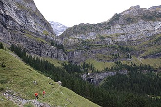
Ascent towards Pas d'Encel |
|||
| Compass direction | northwest | east | |
| Pass height | 1814 m above sea level M. | ||
| Canton | Canton of Valais | ||
| Watershed | La Saufla, Vièze → Rhone | La Saufla, Vièze → Rhone | |
| Valley locations | Champéry , Val-d'Illiez | Evionnaz | |
| expansion | Mule track | ||
| Mountains | Valais Alps | ||
| map | |||
|
|
|||
| Coordinates | 556 897 / 110044 | ||
The Pas d'Encel is an 1814 m above sea level. M. high Saumpass over the Alps . It connects the commune of Champéry ( 994 m above sea level ) in Val-d'Illiez with the commune of Evionnaz ( 484 m ), both in the canton of Valais .
The pass also serves as an approach to the Cabane de Susanfe of Champéry (normal route). With a hiking time of 3½ to 4 hours, 1160 meters of ascent are conquered (degree of difficulty T3). Caution is advised at the Pas d'Encel because the rock is often damp. Fixed steel cables are available.

