
Rattelsdorf (Thuringia)
| coat of arms | Germany map | |
|---|---|---|
 Help on coat of arms |
Coordinates: 50 ° 49 ' N , 11 ° 46' E |
|
| Basic data | ||
| State : | Thuringia | |
| County : | Saale-Holzland district | |
| Management Community : | Hills / valleys | |
| Height : | 280 m above sea level NHN | |
| Area : | 3.67 km 2 | |
| Residents: | 75 (Dec. 31, 2019) | |
| Population density : | 20 inhabitants per km 2 | |
| Postal code : | 07646 | |
| Area code : | 036426 | |
| License plate : | SHK, EIS, SRO | |
| Community key : | 16 0 74 071 | |
| Address of the municipal administration: |
Dorfstrasse 19 07646 Rattelsdorf |
|
| Website : | ||
| Mayor : | Jürgen Meinhardt | |
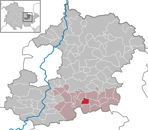
| Location of the municipality of Rattelsdorf in the Saale-Holzland district | ||
  |
||

Rattelsdorf is a municipality in the southeast of the Saale-Holzland district in Thuringia and part of the Hügelland / Täler administrative community .
geography
The place is with its area of 365 hectares in a right side valley of the Weissbach rising to the west . He is one of the valley villages . At the western end of the village begins a large forest area, the Thuringian woodland .
history
Rattelsdorf was first mentioned in a document in 1412.

politics
The municipal council consists of 6 seats (as of 2014):
FDP: 6
traffic
The nearest train stations are Stadtroda on the Weimar – Jena – Gera line and Neustadt (Orla) on the Leipzig – Gera – Saalfeld – Probstzella line , each about 12 to 13 km from Rattelsdorf.
Attractions
The most important attraction of the village is the village church Rattelsdorf ( location → ).
Individual evidence
- ^ Population of the municipalities from the Thuringian State Office for Statistics ( help on this ).
- ^ Wolfgang Kahl : First mention of Thuringian towns and villages. A manual. 5th, improved and considerably enlarged edition. Rockstuhl, Bad Langensalza 2010, ISBN 978-3-86777-202-0 , p. 227.
- ↑ http://www.wahlen.thueringen.de/wahlseite.asp?aktiv=KW01&startbei=kommunalwahlen/KW_wahlresult.asp
Web links
Albersdorf | Altenberga | Bad Klosterlausnitz | Bibra | Bobeck | Bremsnitz | Bucha | Bürgel | Crossing the Elster | Dornburg-Camburg | Eichenberg | Eineborn | Eisenberg | Frauenprießnitz | Outdoor orla | Geisenhain | Gneus | Golmsdorf | Gosen | Graitschen at Bürgel | Greater buckedra | Grosseutersdorf | Großlöbichau | Großpürschütz | Gumperda | Hainichen | Hainspitz | Hartmannsdorf | Heathland | Hermsdorf | Hummelshain | Jenalöbnitz | Kahla | Karlsdorf | Little buckedra | Kleinebersdorf | Kleineutersdorf | Laasdorf | Lehesten | Lindig | Lippersdorf-Erdmannsdorf | Löberschütz | Mertendorf | Meusebach | Milda | Möckern | Mörsdorf | Nausnitz | Neuengönna | Oberbodnitz | Orlamünde | Ottendorf | Petersberg | Poxdorf | Rattelsdorf | Rauda | Rauschwitz | Rausdorf | Reichenbach | Reinstädt | Renthendorf | Rothenstein | Ruttersdorf-Lotschen | Scheiditz | Schkölen | Grinding trips | Schlöben | Schöngleina | Schöps | Side rod | Serba | Silbitz | Stadtroda | St. Gangloff | Sulza | Tautenburg | Tautendorf | Tautenhain | Animal snail | Tissa | Trobnitz | Trockenborn-Wolfersdorf | Unterbodnitz | Waldeck | Walpernhain | Waltersdorf | Weissbach | Weißenborn | Wichmar | Rooms | Zollnitz