
Rozhanovce
| Rozhanovce | |||
|---|---|---|---|
| coat of arms | map | ||

|
|
||
| Basic data | |||
| State : | Slovakia | ||
| Kraj : | Košický kraj | ||
| Okres : | Košice-okolie | ||
| Region : | Košice | ||
| Area : | 22.207 km² | ||
| Residents : | 2,580 (Dec 31, 2019) | ||
| Population density : | 116 inhabitants per km² | ||
| Height : | 215 m nm | ||
| Postal code : | 044 42 | ||
| Telephone code : | 0 55 | ||
| Geographic location : | 48 ° 45 ' N , 21 ° 21' E | ||
| License plate : | KS | ||
| Kód obce : | 521931 | ||
| structure | |||
| Community type : | local community | ||
| Administration (as of November 2018) | |||
| Mayor : | Viktor Gazdačko | ||
| Address: | Obecný úrad Rozhanovce SNP 48 04442 Rozhanovce |
||
| Website: | www.rozhanovce.sk | ||
| Statistics information on statistics.sk | |||

Rozhanovce (German Roscho [no] wetz , Hungarian Rozgony ) is a municipality in eastern Slovakia . It is located in the Košická kotlina valley on the Torysa River , about 10 km from Košice .
The place was first mentioned in writing in 1270 as terra Ruzgum . The battle of Rozhanovce between the Aba family , the de facto rulers in Upper Hungary at the time , and the Hungarian King Charles I was fought on June 15, 1312 near the village.
Personalities
- Leopold Horovitz (1837–1917), portrait painter
Attractions
- Churches in Rozhanovce
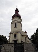
Exaltation of the Cross Church

Church of the Seven Sorrows of Our Lady

