
Paňovce
| Paňovce | |||
|---|---|---|---|
| coat of arms | map | ||

|
|
||
| Basic data | |||
| State : | Slovakia | ||
| Kraj : | Košický kraj | ||
| Okres : | Košice-okolie | ||
| Region : | Košice | ||
| Area : | 20.68 km² | ||
| Residents : | 607 (Dec. 31, 2019) | ||
| Population density : | 29 inhabitants per km² | ||
| Height : | 241 m nm | ||
| Postal code : | 044 71 | ||
| Telephone code : | 0 55 | ||
| Geographic location : | 48 ° 39 ' N , 21 ° 4' E | ||
| License plate : | KS | ||
| Kód obce : | 521850 | ||
| structure | |||
| Community type : | local community | ||
| Administration (as of November 2018) | |||
| Mayor : | Rozália Juhászová | ||
| Address: | Obecný úrad Panovce č.95 044 71 Čečejovce |
||
| Statistics information on statistics.sk | |||

Paňovce (Hungarian Pany ) is a municipality in Okres Košice-okolie ( Košický kraj ) in the east of Slovakia , with a population of 607 (as of December 31, 2019).
geography
The municipality is located about 22 kilometers west of the city of Košice and seven kilometers northeast of Moldava nad Bodvou . The 20.68 km² large municipal area extends from the southeastern edge of the Slovak Ore Mountains to the fertile hills of the foothills, the heights of which gradually decrease towards the Ida valley - part of the Košická kotlina basin . The western third of the municipality is characterized by deciduous forests interrupted by clearing islands. Here heights of over 400 m above sea level are reached, while the village center of Paňovce is 241 m above sea level. The most striking peak, however, is the 306 m high Tárkán mountain spur on the northeast edge of the village. The mountain streams Čečejovský potok, Lesný potok and Stavenec, which drain to the Ida, flow through the municipal area in a north-south direction .
Neighboring municipalities of Paňovce are Nováčany in the north, Hodkovce and Šemša in the northeast, Veľká Ida in the east, Čečejovce in the south, Mokrance in the southwest, Debraď in the west and Rudník in the northwest.
history
Paňovce was first mentioned in writing in 1274, when King Ladislaus IV gave the village to two sons from the Aba family as a fief. These further divided the property in 1301. As early as 1317 there was a first parish church that belonged to the Archdiocese of Esztergom-Budapest . Two years later it was under the Archdiocese of Eger . Parts of the village, like Hodkovce and the no longer existing Rozpút, belonged to today's municipality of Šemša . In the 1330s there were frequent quarrels between the Aba family and their immediate neighbors. After the death of the local rule, Paňovce came under the influence of the Jasov monastery . The territorial disputes did not end until 1390 when Paňovce lost the Seleška suburb to Čečejovce .
In 1427 there were 29 farms in Paňovce, which corresponds to 145 inhabitants with an average of five people per farm.
According to the historian Branislav Varsik (1904–1994), the oldest traditional place name - Paan - is of Slovak origin and comes from the Old Slavic Pan (= Latin Dominus or German Herr ).
- 1274 - Paan
- 1317 - de Pan or Pan Villa
- 1332 - Paan
- 1335 - Pany
- 1407 - Paan
- 1773 - Panowcze in Slovak , Pány in Hungarian
- 1808 - Paňovce
In the 13th century the Hungarian-speaking population began to move north. The Hungarians soon settled the entire Ida lowland, which in the 15th century was considered largely Magyarized . North of Paňovce, at the foot of the Slovak Ore Mountains , this migration came to a standstill - the mountain regions remained predominantly Slovak-speaking. In the second half of the 16th century there was a second wave of Hungarian immigration due to the impending Turkish wars . In the first half of the 17th century, Paňovce was completely Magyarized. The Reformed Church also dates from this period. After 1720 there was an opposite movement of the population from north to south - Slovak immigrants settled in Hungarian villages. In 1851 there were 815 (mostly Slovak) Catholics, 107 (Hungarian) Calvinists and Protestants and 71 Jews in Paňovce.
Until 1919 Paňovce belonged to Abaúj-Torna County in the Kingdom of Hungary and then came to Czechoslovakia. From 1938 to 1945 the community was once again part of Hungary due to the First Vienna Arbitration .
population
According to the results of the 2001 census, there were 564 inhabitants in Paňovce, including those
- 91.3% Slovaks and
- 7.8% Hungary.
75.5% of the residents committed themselves to the Roman Catholic Church.
Attractions
- Roman Catholic parish church
- reformed Church
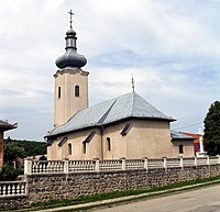
Roman Catholic Church
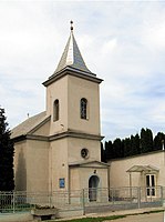
reformed Church


Economy and Infrastructure
The community has retained its rural character. The residents work in agriculture (grain and fruit growing, dairy farming, pig and poultry fattening), in the service sector or commute to industrial plants in and around Košice . There is a grocery store, library, kindergarten and two schools in the village.
Paňovce is only connected to the national road network by a road to the south of Čečejovce . From the west, north and east you can only get to Paňovce on narrow field or forest roads. However, trunk road 50 (here also part of European route 58 ) runs through Čečejovce from Košice via Rožňava to Bratislava . On the southern edge of the village of Čečejovce is the Mokrance station on the Košice-Barca-Rožňava railway line .
Individual evidence
- ↑ History summary on panovce.ocu.sk (Slovak)
- ↑ Statistics on app.statistics.sk/mosmis ( Memento of the original from December 12, 2013 in the Internet Archive ) Info: The archive link was inserted automatically and has not yet been checked. Please check the original and archive link according to the instructions and then remove this notice.
Web links
- Panovce on obce.info/slovensko/ (Slovak)