Košické Oľšany
| Košické Oľšany | ||
|---|---|---|
| coat of arms | map | |

|
|
|
| Basic data | ||
| State : | Slovakia | |
| Kraj : | Košický kraj | |
| Okres : | Košice-okolie | |
| Region : | Košice | |
| Area : | 8.67 km² | |
| Residents : | 1,334 (Dec 31, 2019) | |
| Population density : | 154 inhabitants per km² | |
| Height : | 193 m nm | |
| Postal code : | 044 42 | |
| Telephone code : | 055 | |
| Geographic location : | 48 ° 44 ' N , 21 ° 21' E | |
| License plate : | KS | |
| Kód obce : | 521591 | |
| structure | ||
| Community type : | local community | |
| Administration (as of November 2019) | ||
| Mayor : | Slavomír Horváth | |
| Address: | Obecný úrad Košické Oľšany 118 04442 Košické Oľšany |
|
| Website: | www.kosickeolsany.sk | |
| Statistics information on statistics.sk | ||
Košické Oľšany (1948–1969 Košické Olšany ) is a municipality in eastern Slovakia with 1200 inhabitants.
The proximity of the municipality Košické Oľšany to Košice and the good transport connections have led to an increase in the population in recent years. In 1991 the community had 895 inhabitants, at the end of 2007 there were already 1200 inhabitants. Today Košické Oľšany is the primary school location.
geography
The municipality of Košické Oľšany is the direct eastern neighbor of the city of Košice , about six kilometers as the crow flies from its center. Košické Oľšany is located on the left (eastern) bank of the Torysa . The Torysa Valley, which is about 2000 meters wide here, is separated to the west by the Košická hora ridge from the Hornád Valley , which flows through Košice. Košická Nová Ves is a district of Košice on the ridge of the ridge . The Torysatal around Košické Oľšany is an extension of the Košická kotlina basin . Košické Oľšany is surrounded by the neighboring communities Rozhanovce in the north, Ďurďošík in the northeast, Olšovany in the southeast, Sady nad Torysou in the south and Košice in the west.
history
Košické Oľšany consists of two settlement centers - the long independent villages Vyšný Olčvár and Nižný Olčvár , which were united in 1944 and have since grown together. The original two places were first mentioned in 1288 under the name villa Olchwar . In 1598 Vyšný Olčvár had 16 and Nižný Olčvár 21 houses.
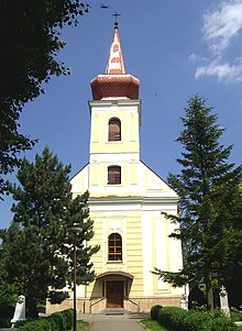
The Roman Catholic church svätého Štefana Uhorského dates from 1810 and was restored from 1875 to 1879 and 1911.
population
The population of the municipality Košické Oľšany consists of 89% Slovaks , 8% of the residents are Roma . 83% of the inhabitants profess to the Roman Catholic Church , 4% of the inhabitants stated that they were Greek Catholics and about 3% that they were Reformed .
Transport links
The busy trunk road 50 ( Košice - Michalovce ), which also forms a section of the European route 50 , runs through Košické Oľšany . The road from Rozhanovce via Košické Oľšany to Košická Polianka runs along the Torysa Valley . According to plans, the final expansion of the D1 motorway from Prešov will follow the Torysatal to Košické Oľšany and turn east towards the Ukrainian border immediately north of the municipality.
Individual evidence
- ↑ MOŠ statistics portal ( page no longer available , search in web archives ) Info: The link was automatically marked as defective. Please check the link according to the instructions and then remove this notice.

