Dvorníky-Včeláre
| Dvorníky-Včeláre | ||
|---|---|---|
| coat of arms | map | |

|
|
|
| Basic data | ||
| State : | Slovakia | |
| Kraj : | Košický kraj | |
| Okres : | Košice-okolie | |
| Region : | Košice | |
| Area : | 13.63 km² | |
| Residents : | 536 (Dec. 31, 2019) | |
| Population density : | 39 inhabitants per km² | |
| Height : | 204 m nm | |
| Postal code : | 044 02 (Post Turňa nad Bodvou ) | |
| Telephone code : | 0 55 | |
| Geographic location : | 48 ° 36 ' N , 20 ° 50' E | |
| License plate : | KS | |
| Kód obce : | 559873 | |
| structure | ||
| Community type : | local community | |
| Administration (as of November 2018) | ||
| Mayor : | Csaba Simkó | |
| Address: | Obecný úrad Číslo: 4, Dvorníky-Včeláre 044 02 Turňa nad Bodvou |
|
| Statistics information on statistics.sk | ||
Dvorníky-Včeláre (Hungarian Méhészudvarnok ) is a small municipality in eastern Slovakia with 536 inhabitants (as of December 31, 2019). It is located in Okres Košice-okolie , a part of Košický kraj .
geography
The 13.63 km² large double community Dvorníky-Včeláre is located in the wide valley of the Turňa in the extreme southwest of the Okres Košice-okolie. In the north of the municipality the Slovak Karst reaches the Turňatal, in the south a long and narrow mountain spur forms the border with Hungary as a foothill of the Aggtelek Karst . While the valley floor, which is mainly used for agriculture, is about 200 m above sea level, the wooded ridge on the Hungarian border reaches 440 m, the also wooded foothills of the Slovak Karst in the northwest almost exceed the 600 m contour line. Dvorníky , the larger of the two villages, lies in the north, the smaller Včeláre in the south-west of the municipality. Immediately south of Včeláre the over 100 m high cliff of a limestone quarry towers; to the west of Dvorníky rises the striking mountain top of the Zemné hradisko .
Neighboring municipalities of Dvorníky-Včeláre are Zádiel in the north, Turňa nad Bodvou in the east, Hosťovce in the southeast, Hidvégardó (Hungary) in the south, Tornanádaska (Hungary) in the southwest, Hrhov in the west and Bôrka in the northwest.
history
The church in its present form is still relatively young. It emerged in 1990 from the community of Zádielske Dvorníky , which had existed since 1964 , when the village of Zádiel was separated from the community and has since been an independent community again.
Dvorníky
Dvorníky was first mentioned in 1314 as Udvarniky . Finds of ceramic shards in the area around Dvorníky show that people settled there as early as the Neolithic Age. From the second half of the 13th century, the residents of Dvorníkys and other surrounding villages were subjects of the lords of the Tornau Castle ( Turňa nad Bodvou municipality ). In 1567 there were ten Hungarian-speaking farming and winemaking families, in 1828 Dvorníky already had 89 houses.
Včeláre
Včeláre was first mentioned in a document in 1345 as Mehes (Hungarian for beekeeper ) and was already predominantly settled by Hungarians. From the 14th to the 16th century, the village was owned by noble families living in the area. In 1598 there were six farmhouses, in 1828 there were 25 houses.
According to the First Vienna Arbitration , Dvorníky and Včeláre also belonged to the Hungarian Abaúj County from 1938 to 1945 .
population
According to the results of the 2001 census, Dvorníky-Včeláre had 445 inhabitants, 68.1% of them Hungarians and 31.5% Slovaks. 80.1% of the residents committed themselves to the Roman Catholic Church.
Attractions
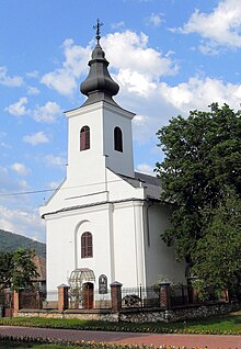
- Church of the Exaltation of the Cross ( kostol povýšenia Svätého kríža ) in Dvorníky from 1801
- Chapel of the Crucifixion of Christ ( kaplnka Ukrižovania kríža ) in Dvorníky
- Reformed church in Včeláre from 1792
- Manor house in Dvorníky
Economy and Infrastructure
The community has retained its rural character. The residents work in agriculture, in the service sector or commute to nearby industrial plants. The village has a grocery store, library, kindergarten and elementary school. The largest employer in the municipality, however, is a building materials company that was established in the south-east of the municipality in the early 1960s. Its towers, silos, heaps and conveyor belts can be seen for miles. The company's product range still includes cement, precast concrete parts and mixtures for road construction. The operation provided the prerequisites for the construction of the East Slovak steel works ( Východoslovenské železiarne , today US Steel Košice ). When the first blast furnace was blown there in 1965, the prefabricated parts of the building materials company were also used to create the prefabricated buildings for the workers' town of Šaca near the steelworks. The basic material for production is sand-lime brick, which is mined in the quarry immediately south of Včeláre, among other places.
Transport links
The Turňatal , which runs in a west-east direction, has always been predestined for the construction of nationally important traffic routes to and from Košice . For example, trunk road 50 (here also part of European route 58 ) runs through the area of the municipality Dvorníky-Včeláre from Košice via Rožňava to Bratislava and the Košice-Barca-Rožňava railway line .
swell
- ↑ Dvorníky-Včeláre on portal.gov.sk. Retrieved April 18, 2011 (Slovak).
- ↑ Statistical data on statistics.sk/mosmis ( page no longer available , search in web archives ) Info: The link was automatically marked as defective. Please check the link according to the instructions and then remove this notice. (Slovak)


