
Slanec
| Slanec | |||
|---|---|---|---|
| coat of arms | map | ||

|
|
||
| Basic data | |||
| State : | Slovakia | ||
| Kraj : | Košický kraj | ||
| Okres : | Košice-okolie | ||
| Region : | Košice | ||
| Area : | 20.459 km² | ||
| Residents : | 1,516 (Dec. 31, 2019) | ||
| Population density : | 74 inhabitants per km² | ||
| Height : | 355 m nm | ||
| Postal code : | 044 17 | ||
| Telephone code : | 055 | ||
| Geographic location : | 48 ° 38 ' N , 21 ° 29' E | ||
| License plate : | KS | ||
| Kód obce : | 522007 | ||
| structure | |||
| Community type : | local community | ||
| Administration (as of November 2018) | |||
| Mayor : | Jozef Bela | ||
| Address: | Obecný úrad Slanec Hlavná 55/114 04417 Slanec |
||
| Website: | www.slanec.sk | ||
| Statistics information on statistics.sk | |||

Slanec (Slovak until 1927 "Sálanc"; Hungarian Nagyszalánc ) is a municipality in eastern Slovakia .
location
It is located in the Slanské vrchy , which gives it its name, on a pass about 24 km from Košice .
history
The place was first mentioned in 1301 and developed from a settlement below the Slanec Castle (first mentioned in 1281).
Attractions
- the ruins of Slanec Castle
- Roman Catholic Church from 1754
- a fort below the castle from the 2nd half of the 18th century
See also: List of listed objects in Slanec

View of Slanec
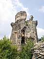
Castle ruins

Roman Catholic Church


Web links
Commons : Slanec - collection of images, videos and audio files