Roztoky u Křivoklátu
| Roztoky | ||||
|---|---|---|---|---|
|
||||
| Basic data | ||||
| State : |
|
|||
| Region : | Středočeský kraj | |||
| District : | Rakovník | |||
| Area : | 2221.6124 ha | |||
| Geographic location : | 50 ° 0 ' N , 13 ° 53' E | |||
| Height: | 275 m nm | |||
| Residents : | 1,084 (Jan 1, 2019) | |||
| Postal code : | 270 23 | |||
| License plate : | S. | |||
| traffic | ||||
| Street: | Zdice - Rakovník | |||
| Railway connection: | Rakovník – Beroun | |||
| structure | ||||
| Status: | local community | |||
| Districts: | 1 | |||
| administration | ||||
| Mayor : | Vladimír Melč (as of 2013) | |||
| Address: | Roztoky 128 270 23 Křivoklát |
|||
| Municipality number: | 598526 | |||
| Website : | www.obec-roztoky.cz | |||
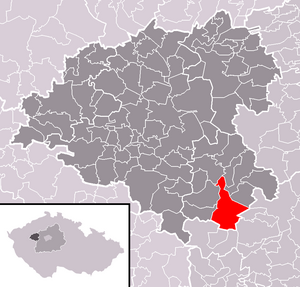
| Location of Roztoky in the Rakovník district | ||||

|
||||
Roztoky (German Rostok , also Rostock ) is a municipality in the Czech Republic . It is located 13 kilometers southeast of Rakovník and belongs to the Okres Rakovník .
geography
Roztoky is located north of the Pürglitzer Uplands ( Křivoklátská vrchovina ) opposite the confluence of the Rakovnický potok in a bend in the river on the Berounka . The community is located in the nature reserve Pürglitzer Wald . The Beraník ( Schafberg ) rises to the south at 498 m.
Neighboring towns are Městečko ( Stadtl ) and Křivoklát ( Křivoklát ) in the north, Pohořelec ( Pohorzeletz ) and Újezd nad Zbečnem ( Augezd whether Zbetschno ) in the northeast, Zbečno ( Zbetschno ) and Račice ( Radschitz ) to the east, Častonice ( Tschastonitz ) and Leontýn ( Thiergarten ) in the southeast, Karlova Ves ( Karlsdorf ) in the south, Branov ( Branow ) in the southwest and Velká Buková ( Groß Bukowa ) in the northwest.
history
At the site of today's village there was originally a court of the Pürglitz castle bailiff Jíra von Roztoky, which was extinct around 1370. The village, first mentioned in a document in 1406 and belonging to the rule Pürglitz , was built in its place .
In 1779 the Karlhof was built next to the village. The former farmyard grew into a small settlement. In 1820 the Obora hunting lodge was built in the Pürglitzer Wald. Max zu Fürstenberg had it built into a neo-Gothic palace for his wife Leontine, née 1865-1866. from Khevenhüller.
After the founding of an ironworks by the Princes zu Fürstenberg in 1824, the place experienced an economic boom. The Stein & Sohn textile factory was established at the beginning of the 20th century. After 1945 a machine tool factory was set up in Roztoky, from which the compressed air equipment manufacturer PERMON emerged in the 1960s. In the valley of the Klucná brook there is the Údolí hříchů holiday settlement, which is one of the oldest in the Czech Republic.
Local division
No districts are shown for the municipality of Roztoky. Basic settlement units are Karlov ( Karlhof ), Leontýn, Placanda and Roztoky.
Attractions
- wooden bell tower from the 19th century in the center of the village
- Křivoklát Castle
- Leontýn Castle with English Park in Leontýn, today serves as a social welfare institution for the city of Prague
- Chapel of St. Wenceslas in Leontýn Castle Park, built in 1866
- Statue of St. Wenceslas in Leontýn Castle Park, erected in 1893
- Červený kříž nature reserve
Individual evidence
- ↑ http://www.uir.cz/obec/598526/Roztoky
- ↑ Český statistický úřad - The population of the Czech municipalities as of January 1, 2019 (PDF; 7.4 MiB)
- ↑ Antonín Profous: Místní jména v Čechách - Vznik jejich, původní význam a změny.
- ↑ http://www.uir.cz/zsj-obec/598526/Obec-Roztoky


