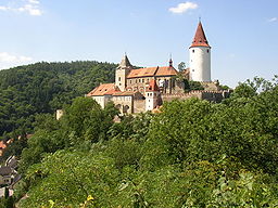
Křivoklát
| Křivoklát | ||||
|---|---|---|---|---|
|
||||
| Basic data | ||||
| State : |
|
|||
| Historical part of the country : | Bohemia | |||
| Region : | Středočeský kraj | |||
| District : | Rakovník | |||
| Area : | 642.5146 ha | |||
| Geographic location : | 50 ° 2 ' N , 13 ° 53' E | |||
| Height: | 250 m nm | |||
| Residents : | 679 (Jan. 1, 2019) | |||
| Postal code : | 270 23 | |||
| License plate : | S. | |||
| traffic | ||||
| Railway connection: | Rakovník – Beroun | |||
| structure | ||||
| Status: | stains | |||
| Districts: | 3 | |||
| administration | ||||
| Mayor : | Milan Naď (as of 2013) | |||
| Address: | Dr. Miroslava Tyrše 93 270 23 Křivoklát |
|||
| Municipality number: | 541982 | |||
| Website : | www.mestys-krivoklat.cz | |||
| Location of Křivoklát in the Rakovník district | ||||

|
||||
The spot Křivoklát (German Pürglitz , older Burglitz ) with 680 inhabitants is located in the Central Bohemia region in the Czech Republic . Křivoklát is located at the confluence of the Rakovnický creek in the Berounka in the Pürglitzer Forest , the area has been included in the protection program of UNESCO as the Křivoklátsko biosphere landscape .
history
The history of the place, first mentioned in 1110, is closely linked to the history of the Křivoklát Castle . In the 14th century, laborers and craftsmen began to settle below the castle. This place was called Budy at the beginning. In the 16th century a courtyard and a manor mill were built. After the marriage of Karl Egon II zu Fürstenberg with Amalie von Baden in 1818, he merged the individual districts that had arisen up to that point and renamed them Amalienberg ( Amalín ). On December 1, 1886, the population decided to rename it to Pürglitz (Křivoklát). The town belonged to the Fürstenbergs until 1929, when it was sold to the Czech state. In 2006 the status as a minor town (Czech: Městys ) was renewed. The Anetta Keys model was born here in 1983.
Attractions
- Křivoklát Castle
- Neo-Gothic Church of St. Peter (1880–1885), built on the foundations of the church from 1522.
- Birthplace of the violinist Ferdinand Laub .
- Monument to Karl Egon II. Zu Fürstenberg (Czech Karel Egon II. Z Fürstenberka), built in 1858 by Karl J. Svoboda , also in neo-Gothic style, height 14 m.
- Renaissance mill, birthplace of court painter Matěj Huťský
- Paraplíčko lookout tower above Berounka with a view of the wooded areas and the town of Roztoky , where the former princely ironworks were located.
- Chapel of Saint Eustach (1697)
- Monuments of St. John Nepomuk
- Chapel of the Virgin Mary
Community structure
The municipality Křivoklát consists of the districts Častonice ( Tschastonitz ), Křivoklát and Písky. Basic settlement units are Amalín ( Amalienberg ), Častonice, Křivoklát and Písky.
Individual evidence
- ↑ http://www.uir.cz/obec/541982/Krivoklat
- ↑ Český statistický úřad - The population of the Czech municipalities as of January 1, 2019 (PDF; 7.4 MiB)
- ↑ http://mapy.mzk.cz/mzk03/001/036/923/2619267333/
- ↑ http://www.uir.cz/casti-obce-obec/541982/Obec-Krivoklat
- ↑ http://www.uir.cz/zsj-obec/541982/Obec-Krivoklat


