Velká Buková
| Velká Buková | ||||
|---|---|---|---|---|
|
||||
| Basic data | ||||
| State : |
|
|||
| Region : | Středočeský kraj | |||
| District : | Rakovník | |||
| Area : | 1,353.1281 ha | |||
| Geographic location : | 50 ° 2 ' N , 13 ° 51' E | |||
| Height: | 435 m nm | |||
| Residents : | 269 (Jan 1, 2019) | |||
| Postal code : | 270 23 | |||
| License plate : | S. | |||
| traffic | ||||
| Street: | Všetaty - Roztoky | |||
| structure | ||||
| Status: | local community | |||
| Districts: | 3 | |||
| administration | ||||
| Mayor : | Josef Bumba (as of 2013) | |||
| Address: | Velká Buková 82 270 23 Velká Buková |
|||
| Municipality number: | 542563 | |||
| Website : | www.velkabukova.cz | |||
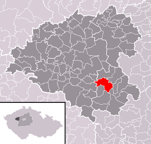
| Location of Velká Buková in the Rakovník district | ||||

|
||||
Velká Buková (German Groß Bukowa , 1939–45 Groß Buchen ) is a municipality in the Czech Republic . It is located twelve kilometers southeast of Rakovník and belongs to the Okres Rakovník .
geography
Velká Buková is located in the highlands Křivoklátská in the conservation area Křivoklátsko . The village lies on the unwooded plateau of Buková in the Pürglitzer forest, which is surrounded by the Trnava brook in the north, the Rakovnický potok in the east and the Berounka in the south . The Losy rises to the northeast (434 m), the Americas (413 m) to the south, the Porostlina (454 m) to the southwest, the Čepína (469 m) to the west and the Spálený Kopec (407 m) to the northwest.
Neighboring towns are Emilov, Kolonie, Míče, Losy and Městečko in the north, Písky in the north-east, Křivoklát , Amalín and Dubina in the east, Roztoky in the south-east, Višňová and Branov in the south, Nezabudice , Hracholusky , Novosedly and Skřivaň , Malihátku in the south-west, Naihátku Buková and Všetaty in the west and Čepiny, Lašovice , Pustověty and Kalubice in the northwest.
history
The village was first mentioned in writing in 1386.
In Velká Buková a sulfur works was operated by the Pürglitz rule. In 1685 Leopold I sold the crown rule of Pürglitz to Ernst Joseph Count von Waldstein . In 1731 Johann Joseph Graf von Waldstein bequeathed the rule to his daughter and universal heiress Maria Anna Fürstin zu Fürstenberg , who in 1756 united her in a will with the rule of Kruschowitz and the Gut Nischburg to form a family entailment of 400,000 guilders. Half of the inheritance went to her sons Joseph Wenzel zu Fürstenberg-Stühlingen and Karl Egon I zu Fürstenberg, the other half to her daughters Henriette Fürstin von Thurn und Taxis and Maria Theresia zu Fürstenberg. She appointed her second-born son Karl Egon I as Fideikommisserbeer, who also acquired the shares of his siblings through compensation. In 1786 the Religionsfond established a locality in Stadtl , of which Pustowied belonged. After the death of Karl Egon I, his eldest son Philipp Fürst zu Fürstenberg († 1790) inherited the property in 1787, followed by his children Karl Gabriel zu Fürstenberg († 1799) and Leopoldine Princess of Hesse-Rothenburg-Rheinfels. In 1803, the female heirs renounced a family settlement in favor of the minor Karl Egon II zu Fürstenberg and the princely and landgrave houses of Fürstenberg; Joachim Egon Landgraf von Fürstenberg was appointed as administrator until he came of age in 1817.
In 1843 Groß-Bukowa consisted of 45 houses with 376 inhabitants. There was a forester's house ( Losy ) aside . The parish was Stadtl . Until the middle of the 19th century, Groß-Bukowa remained subordinate to Fideikommiss Pürglitz .
After the abolition of patrimonial formed Velká Buková / Großbukowa 1850 with the districts Kalubice and Malá Buková a municipality in the district Rakonitz and judicial district Křivoklát . After the death of Karl Egon II zu Fürstenberg in 1854, his second-born son Max Egon I inherited the Fideikommiss Pürglitz. At the beginning of the 20th century, a village school was established in which two-class classes were taught. Kalubice broke up in 1910 and formed its own municipality. During the German occupation , the village was given the German name Groß Buchen . In 1980 Kalubice and Nezabudice were incorporated. Nezabudice broke away from Velká Buková on November 24, 1990.
Community structure
The municipality of Velká Buková consists of the districts Kalubice ( Kalibitz ), Malá Buková ( Klein Bukowa ) and Velká Buková ( Groß Bukowa ), which also form basic settlement units. The municipality is divided into the cadastral districts of Kalubice and Velká Buková. The municipality of Velká Buková also includes the layers Čepiny ( Czepiner Heger ), Losy ( Lossen ) and Na Čihátku.
Attractions
- Baroque statue of St. Wenceslas from 1766, at the school
- Baroque statue of St. John of Nepomuk in the village square
- Wooden chalets in folk construction
- chapel
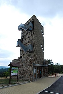
- Wooden observation tower on the western edge of the village, the 15-meter-high building with a triangular floor plan, erected on a stone base, has an observation platform at a height of 13.5 m. The tower opened in September 2009.
- Nezabudické skály nature reserve, south of the village on the slope to the Berounka valley
Web links
Individual evidence
- ↑ http://www.uir.cz/obec/542563/Velka-Bukova
- ↑ Český statistický úřad - The population of the Czech municipalities as of January 1, 2019 (PDF; 7.4 MiB)
- ↑ Johann Gottfried Sommer : The Kingdom of Bohemia. Represented statistically and topographically. Volume 13: Rakonitz Circle. Calve, Prague 1845, p. 284.
- ↑ http://www.uir.cz/casti-obce-obec/542563/Obec-Velka-Bukova
- ↑ http://www.uir.cz/zsj-obec/542563/Obec-Velka-Bukova
- ↑ http://www.uir.cz/katastralni-uzemi-obec/542563/Obec-Velka-Bukova


