
Tacherting
| coat of arms | Germany map | |
|---|---|---|

|
Coordinates: 48 ° 5 ' N , 12 ° 34' E |
|
| Basic data | ||
| State : | Bavaria | |
| Administrative region : | Upper Bavaria | |
| County : | Traunstein | |
| Height : | 473 m above sea level NHN | |
| Area : | 50.24 km 2 | |
| Residents: | 5768 (Dec. 31, 2019) | |
| Population density : | 115 inhabitants per km 2 | |
| Postal code : | 83342 | |
| Primaries : | 08621, 08622, 08634 | |
| License plate : | TS, LF | |
| Community key : | 09 1 89 149 | |
| LOCODE : | DE TTG | |
| Community structure: | 108 districts | |
| Address of the municipal administration: |
Trostberger Str. 9 83342 Tacherting |
|
| Website : | ||
| Mayor : | Werner Disterer ( FREE VOTERS ) | |
| Location of the municipality of Tacherting in the Traunstein district | ||
  |
||

Tacherting is a municipality in the Upper Bavarian district of Traunstein .

.jpg)


geography
Geographical location
The municipality of Tacherting is located in the northern district of Traunstein, about 85 km east of the state capital Munich . The Austrian city of Salzburg is located a good 60 km southeast . The district town of Traunstein is 28 km away. The community is located in the foothills of the Alps in the planning region of Southeast Upper Bavaria . The altitude of the larger districts is distributed relatively differently due to spatial conditions: The districts of Emertsham (528 m above sea level) and Peterskirchen (510 m above sea level) are significantly higher than the largest district of Tacherting itself, which is only located in the Alztal located at around 473 m above sea level .
The east of the municipality is traversed by the Alz , the only outflow from the Chiemsee , which itself is about 20 km away. Due to the proximity to the Alz, there are often floods and an associated rise in the groundwater level . The best example is the flood in Central Europe in 2013 .
Land use
The total area of the municipality is 5024 ha, of which 3575 ha (71.1%) are agricultural land, 928 ha (18.5%) forest area, 455 ha (9.1%) are settlement and traffic area.
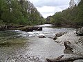
Alz near the Tacherting sewage treatment plant

Alz behind the weir in Tacherting

View from Tacherting to the Chiemgau Alps


Neighboring communities
The municipality of Tacherting is bordered by the municipalities of Taufkirchen ( district of Mühldorf am Inn ) and Engelsberg in the north, Feichten adAlz ( district of Altötting ) in the east, Trostberg in the south, Kienberg in the south-west and Schnaitsee in the west .
Community structure
There are 108 districts in total:
Larger districts are Tacherting, Emertsham, Peterskirchen, Wajon, Reit, Schalchen, Neuschalchen, Degernfeld and Lengloh.
history
timeline
The area around the district of Tacherting has been settled since time immemorial - as evidenced by archaeological finds, etc. a. Barrows from the Neolithic and late Bronze Age . Continuous settlement during Roman times could also be proven, when the area belonged to the Noricum province of the Roman Empire . Extensive excavations at the beginning of the 19th century document these sections of the local history.
In the 6th century the Roman Empire fell into disrepair and the Bavarians immigrated to the places with the ending "-ing" (Tacherting, Taching , Chieming ).
The first mention of Tacherting as "takahartinka" in a deed of donation to the Cathedral Church in Passau dates back to around 735 .
In 788 "Tahardinga" was mentioned in the Notitia Arnonis as a church belonging to Archbishop Arno von Salzburg .
In the middle of the 13th century the Alz was defined as the border between the Duchy of Bavaria and the Archdiocese of Salzburg , Tacherting fell to Lower Bavaria in disputes between the ducal brothers Ludwig and Heinrich .

In the second half of the 15th century, today's parish church of Our Lady was built in Tacherting.
At the Reichstag in Constance in 1507, an imperial decree assigned Tacherting to Upper Bavaria .
With the regulation of the Alz and the construction of the first section of the Alz Canal (1908–1910), hydropower plants were built , and the first industry settled.
In May 1945 the US Army moved in and Tacherting became a hospital area.
In the 1960s there were regular grass track races in Tacherting with up to 18,000 spectators.
In 2009 the German archery championship took place in Tacherting .
Religions
As in the rest of the rural Upper Bavaria , the majority of the population professes the Roman Catholic Church . According to the 1987 census , these were 3,990 citizens of the parish. Only 274 citizens professed their Protestant faith .
Incorporations
On January 1, 1972, the previously independent municipality Emertsham was incorporated. Peterskirchen was added on July 1, 1972 .
Population development
| year | 1840 | 1900 | 1950 | 1961 | 1970 | 1991 | 1995 | 2000 | 2005 | 2006 | 2007 | 2008 | 2009 | 2010 | 2011 | 2012 | 2013 | 2014 | 2015 | 2016 |
| Residents | 1653 | 2143 | 4050 | 3962 | 4516 | 4624 | 5327 | 5507 | 5663 | 5623 | 5574 | 5537 | 5514 | 5480 | 5469 | 5477 | 5486 | 5605 | 5717 | 5761 |
In order to counteract the demographic change , specifically the rural exodus , on January 26, 2012 the municipal council passed the “Guideline for the Promotion of Housing and Families”. The aim of this funding program is to encourage the influx of new residents and the acquisition of residential property by the local population in the municipality. In 2013, 35,000 euros were called up in the funding program, for 2014 65,000 euros were available.
Between 1988 and 2018 the municipality grew from 4,380 to 5,734 by 1,354 inhabitants or by 30.9%.
politics
Municipal council
The municipal council currently consists of 20 members and the 1st mayor. In the local elections in Bavaria in 2020 , the 20 seats in the municipal council were distributed as follows:
The turnout was 59.6% (2014: 45.7%)
mayor
From October 21, 2006 to April 30, 2020, Johann Hellmeier was the first mayor of the community. Due to the change in the electoral legislation, his election from September 23, 2012 was valid for almost eight years until the general local elections in 2020. Since the death of Mayor Josef Breu (1994), the mayoral elections in Tacherting had not been in line with the municipal council elections.
In the 2020 election on March 15, 2020, Werner Disterer (Free Voters) was elected as the new mayor of the municipality from a total of three applicants with 71.22% of the votes.
- 1956 to 1966 Ludwig Steffl
- 1966 to 1994 Josef Breu (CSU)
- 1994 to 2006: Rudolf Schenkl (SPD)
- 2006 to 2020: Johann Hellmeier (CSU and Independent Emertsham)
- since 2020: Werner Disterer (FW)
coat of arms
Description: In blue two crossed golden stalks with golden ears; above a silver gear, below a silver prehistoric urn.
Origin: The ears of grain and the cog wheel are heraldic symbols for agriculture and industry and indicate the importance of these two economic areas in the municipality. The prehistoric urn symbolizes the prehistoric and Roman age finds in the Tacherting area and underlines the fact that the area has been inhabited since the Bronze Age. The burial mounds at Unterbrunnham indicate this. An important Roman settlement was in Lohen near Tacherting. Tacherting has been traceable in written sources since the 8th century.
Design: The municipal coat of arms was designed by Dirscherl, the Garching local home keeper at the time. Following a resolution by the local council, the government of Upper Bavaria approved the draft on February 8, 1960; since then the municipality of Tacherting has had its own coat of arms.
Municipality flag: The municipality flag (white, yellow, blue with municipal coat of arms) comes from the idea of the honorary citizen Urbanek; The municipality of Tacherting has been running this own flag since 1967.
Culture and sights
Tacherting is located in the Alztal, which is often still in a near-natural state in this area. The Tacherting parish church is called: "To our dear lady". In the center of Tacherting is the listed salt barn . In the vicinity there are important excursion destinations such as the Chiemsee or the longest castle in the world in Burghausen . The Chiemgau Alps and well-known winter sports locations such as Ruhpolding or Inzell can be reached in about 45 minutes.

Architectural monuments
Soil monuments
Museums
The privately run Chiemgau School Museum is located in Tacherting, Brandstätt district . The local history museum is located in the primary school in Tacherting. In the basement of the primary school you will find the rooms of the Tacherting Heimatverein with finds from 4000 years of local history. The picture exhibition “3000 years of local history Tacherting” has recently been exhibited there.
Sports
Tacherting can look back on a long sporting past. In the 1950s, Tacherting was famous for its grass track races . The Tachertinger racecourse was one of the fastest in Germany at the time. Up to 18,000 spectators did not miss this spectacle in a place that only had about 4,000 inhabitants. In 1959, these grass track races ended due to property sales. Today the sports clubs in particular contribute to a varied community life.
SV Linde Tacherting
SV Linde Tacherting was founded in 1949 as SV Tacherting. In 1969 the club name was changed to SV Linde Tacherting. There are currently 10 departments with over 1100 members. There are departments for: football, athletics, skiing, curling, senior sports, tennis, table tennis, gymnastics, Tae Kwon Do and volleyball.
The new clubhouse of SV Linde Tacherting was inaugurated on August 19, 2008 after a construction period of 1 ½ years. In autumn 2013 the new 2.5-fold gym of the municipality of Tacherting was officially opened.

TSV Peterskirchen
TSV Peterskirchen was founded in 1967. 1990 Construction of the tennis facility. The men's A soccer team plays in the district league 2.
FSG Tacherting (Feuerschützengesellschaft Tacherting)
Rifle club, archery, air rifle, air pistol ...
German team champion - 1st Bundesliga archery 2002, 2004 and 2008 - in archery
Regular events
Fire brigade festival of the Tacherting volunteer fire brigade, various balls during carnival time .
Economy and Infrastructure
Tacherting is located in the south of the south-east Bavarian chemical triangle . The two most important employers are located in the district of Schalchen: On the one hand, Linde AG (Schalchen plant) with around 800 employees. Here, heavy transports with heat exchangers and air separators often leave the plant in the direction of Passau , where they are then shipped. On the other hand, there is AlzChem (Schalchen plant - formerly Evonik , before Degussa , before that SKW Trostberg plant in Schalchen) with around 100 employees. There are also a number of medium-sized companies. The community itself currently employs 50 people. In the north of Tacherting there is a buildable industrial area (Lochner Feld) directly on the federal highway B 299 . A total of 4.3 hectares of ready-to-build commercial and residential areas are currently available.
The discounter Edeka (Scherer) and Netto are located in the Tacherting district . On the B299 in the center of Tacherting there is a savings bank and a branch of Raiffeisenbank Trostberg-Traunreut eG .
There is a sewage treatment plant near the Alz . The communities of Kienberg and Feichten an der Alz are also connected to this. The first sewage sludge digestion plant in Upper Bavaria has been located in Tacherting since July 2011 .
Power generation
In 2011 and 2010, Tacherting took first place in the Small Town category of the German Solar League Initiative . The municipality Tacherting now ranks in Bavaria in 19th place, in the whole of Germany Bundesliga on the 34th place. (Status: December 18, 2013) Furthermore, the community is listed in the European Champions League for Renewable Energies (RES Champions League), in which Tacherting was named the best small town in the solar energy category on July 5, 2012. Mayor Hans Hellmeier traveled to Rome and received the certificate in the Roman Senate .
Hydropower also plays a decisive role through the use of the Alz River in northern Chiemgau . In the Wajon district of Tacherting there is a hydropower plant which was built from 1908 to 1910 and has an output of 8 MW.
The municipality of Tacherting already covers all of its electricity needs from renewable energies . The municipality covers over 400% of its own electricity consumption.
Community finances / construction activity
The total volume of the 2014 budget of the municipality of Tacherting amounts to 16.24 million euros. The administrative budget amounts to 10.22 million euros, the asset budget 6.02 million euros. The income from trade tax doubled to 7.02 million euros in 2013, and 3.8 million euros were estimated for 2014. The municipal share of income tax in the 2014 budget is 2.46 million euros. Personnel costs amount to 1.84 million euros (19% of the administrative budget). Major expenses in the 2013 budget year were the construction of the new community gymnasium (1.78 million euros), which was completed in autumn 2013, including the outdoor facilities. Another major item was the development of the Hüttinger Feld II building area in the west of Tacherting between the Edeka market and the community cemetery. The new building area was developed from spring 2013, has an area of 2.6 hectares and comprises a total of 35 plots. Currently (February 2014) over 30 lots have already been sold. Several residential buildings have already been under construction since September 2013.
The community's debt (2014: 2.06 million euros) will continue to be reduced; in 2005 the per capita debt was 706 euros; At the end of 2014, 374 euros are expected. The reserves amount to 6.7 million euros in the 2014 budget year, but will merge to 3.7 million euros by 2017. The assessment rate of the trade tax is currently 320%, the assessment rate of the property tax A (agricultural and forestry areas) also 320%, here 85,000 euros are planned in the 2014 budget, with the property tax B (310%) 490,000 euros are estimated.

traffic
The municipal area of Tachertings is mainly accessed via the B 299, which runs in a south-north direction in the Alztal from Trostberg to Altötting . State road 2091 also leads from Trostberg through the western parts of the municipality Emertsham and Peterskirchen towards Waldkraiburg .
With the Traun-Alz Railway , which was completed in 1910 on the entire route , Tacherting, Schalchen and Wiesmühl have a connection to national networks via the Traunstein and Mühldorf nodes via Garching an der Alz .
education

The Tacherting elementary and middle school, consisting of two separate school buildings, has been unofficially called the Dr. Leo Mol School since July 31, 1974, because this well-known Canadian artist has a bear group and a bear group if he has good contacts with various citizens of the community Bronze figure in the swimming pool given to the school or community. There are currently around 460 pupils in primary and secondary schools. Since the secondary schools in Bavaria were converted to middle schools from the 2010/11 school year , the municipality of Tacherting, together with the municipalities of Trostberg and Altenmarkt an der Alz, decided to create the school association Middle School Alztal. There is another elementary school in the Peterskirchen district . The community library is located in the basement of the Tacherting Middle School and currently has more than 10,000 books, magazines, CDs and DVDs available for loan.
The largest music school in the Traunstein district is located in Emertsham , where currently 528 music students are taught by 19 teachers (as of 2011).
There are currently four kindergartens in the municipality of Tacherting : Parish kindergarten Tacherting, Kindergarten St. Vitus in Emertsham, Workers' welfare and forest kindergarten Tacherting.
Personalities
Honorary citizen
- December 1, 1989: Gerhard Meister
- July 1, 2005: Rudolf Urbanek
- May 18, 2008: Irmgard Schwoshuber
Connected to the community
- Armin Garnreiter (born July 24, 1958), archer (FSG Tacherting), multiple German champion
Individual evidence
- ↑ "Data 2" sheet, Statistical Report A1200C 202041 Population of the municipalities, districts and administrative districts 1st quarter 2020 (population based on the 2011 census) ( help ).
- ↑ bayerische-landesbibliothek-online.de
- ^ History of the community of Tacherting. tacherting.de, accessed on July 29, 2019 .
- ^ Wilhelm Volkert (ed.): Handbook of Bavarian offices, communities and courts 1799–1980 . CH Beck, Munich 1983, ISBN 3-406-09669-7 , p. 581 f .
- ↑ Municipal statistics 2010 Tacherting (PDF; 1.3 MB)
- ↑ Preliminary results of the municipal council election on March 15, 2020 - Tacherting municipality. Retrieved March 16, 2020 .
- ↑ Preliminary results of the mayoral election on March 15, 2020 - Tacherting municipality. Retrieved March 16, 2020 .
- ↑ Solar League
- ^ The emperors of renewable energies were crowned in Rome. ( Memento from February 13, 2013 in the web archive archive.today ) RES-League.
- ↑ traunstein.com (PDF; 3.9 MB) Renewable Energies LK Traunstein.
Web links
- Entry on the coat of arms of Tacherting in the database of the House of Bavarian History

Altenmarkt an der Alz | Mountains | Chieming | Engelsberg | Fridolfing | Grabenstätt | Grassau | Inzell | Kienberg | Kirchanschöring | Marquartstein | Nussdorf | Obing | Palling | Petting | Pittenhart | Reit im Winkl | Ruhpolding | Schleching | Schnaitsee | Seeon-Seebruck | Siegsdorf | Staudach-Egerndach | Surberg | Tacherting | Taching at the lake | Tittmoning | Traunreut | Traunstein | Trostberg | Overseas | Unterwössen | Vachendorf | Waging am See | Wonneberg
Unregulated areas: Chiemsee | Waginger See