
Saint-Jean-Cap-Ferrat
| Saint-Jean-Cap-Ferrat | ||
|---|---|---|

|
|
|
| region | Provence-Alpes-Cote d'Azur | |
| Department | Alpes-Maritimes | |
| Arrondissement | Nice | |
| Canton | Beausoleil | |
| Community association | Nice Cote d'Azur | |
| Coordinates | 43 ° 41 ′ N , 7 ° 20 ′ E | |
| height | 0-143 m | |
| surface | 2.48 km 2 | |
| Residents | 1,573 (January 1, 2017) | |
| Population density | 634 inhabitants / km 2 | |
| Post Code | 06230 | |
| INSEE code | 06121 | |
| Website | www.saint-jean-cap-ferrat.fr | |

Saint-Jean-Cap-Ferrat is the name of a French municipality and a small town with port facility in the region Provence-Alpes-Côte d'Azur , the Alpes-Maritimes department , Arrondissement of Nice , Canton Beausoleil with a total of 1,573 inhabitants (1st January 2017). It is a member of the Nice Côte d'Azur metropolis .
geography
The municipality and town of Saint-Jean-Cap-Ferrat is located between Nice and Monaco on the Côte d'Azur on the Cap Ferrat peninsula , which is surrounded on three sides by the sea.
Neighboring municipalities are Villefranche-sur-Mer in the west and Beaulieu-sur-Mer in the east.
According to a study by the Knight Frank company , Saint-Jean-Cap-Ferrat is the most expensive place in the world with an average of 30,300 euros per square meter of land.
Population development
| year | 1962 | 1968 | 1975 | 1982 | 1990 | 1999 | 2009 | 2016 |
| Residents | 2,416 | 2,356 | 2,268 | 2,215 | 2,248 | 1,895 | 2,035 | 1,618 |
| Sources: Cassini and INSEE | ||||||||
Attractions
See also: List of Monuments historiques in Saint-Jean-Cap-Ferrat
- La Villa Ephrussi de Rothschild : also known as "Villa Ile-de-France", is one of the most beautiful Neo-Renaissance palaces on the Côte d'Azur. Built between 1905 and 1912 in Saint-Jean-Cap-Ferrat by Baroness Béatrice Ephrussi de Rothschild (1864–1934).
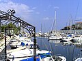
Saint-Jean-Cap-Ferrat marina
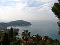
View of the Cap Ferrat from Villefranche-sur-Mer seen from

Saint-Jean-Cap-Ferrat from Beaulieu-sur-Mer seen from

View of the Cap Ferrat from Eze seen from

Beaulieu-sur-Mer as seen from the Saint-Hospice cemetery in Saint-Jean-Cap-Ferrat

The Black Madonna of Saint-Jean-Cap-Ferrat


literature
- Le Patrimoine des Communes des Alpes-Maritimes . Flohic Editions, Volume 2, Paris 2000, ISBN 2-84234-071-X , pp. 1025-1032.
Individual evidence
- ↑ Russian Villa Roulette from October 7, 2008
Web links
- Website of the municipality of Saint-Jean-Cap-Ferrat (French)
- Villa Ephrussi de Rothschild (French, English)