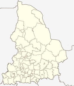
Staroutkinsk
| Urban-type settlement
Staroutkinsk
Староуткинск
|
||||||||||||||||||||||||||||||||||||||
|
||||||||||||||||||||||||||||||||||||||
|
||||||||||||||||||||||||||||||||||||||
Staroutkinsk ( Russian Староу́ткинск ) is an urban-type settlement in Sverdlovsk Oblast in Russia with 2969 inhabitants (as of October 14, 2010).
geography
The place is about 90 km as the crow flies northwest of the Yekaterinburg Oblast Administrative Center on the western flank of the Urals . It is located on the Tschussowaja river , at the confluence of the Utka (in the upper reaches Dikaja Utka, Wilde Utka ) from the left and the Darja from the right. The Utka is dammed in the area of the place, just above the confluence with the "Staroutkinsker Teich" (Staroutkinski prud) .
Staroutkinsk is the administrative center of the Staroutkinsk district , which also includes the villages of Kurja (3 km southeast), Utkinski Zavod (6 km southwest) and Volyny (7 km south). The settlement is free of parishes, as there is no corresponding administrative level (here city parish / gorodskoje posselenije ), as is common in urban districts in Russia.
history
The place was founded by the Old Orthodox in the first half of the 1670s . It gained importance with the establishment of a metallurgical plant by Akinfi Demidow in the 18th century, named after the river Utkinski Zavod ("Utka plant"). It went into operation on September 1, 1729 and was expanded several times.
In 1749, about 30 km south-east, another, initially state-owned plant, later owned by the entrepreneur Sawwa Jakowlew , was built on another left Chusovaya tributary called Utka (also Verkhnyaya Utka, Obere Utka ). The names Utka Demidowa ("Demidows Utka") and Utka Jakowlewa ("Jakowlews Utka") have become commonplace for the associated settlements ; In the Soviet period, the corresponding names Staraja Utka ("Old Utka") and Nowaja Utka ("New Utka") became official. Utka means “ duck ” in Russian , which is also reflected in the coat of arms; The river and place names in the Urals - there are more - have nothing to do with the birds etymologically.
Since 1933 the place has had the status of an urban-type settlement under its current name. It belonged to the Schalinski rajon with its seat in Shalya , 35 km to the west , until it was spun off on December 17, 1995 into an independent administrative unit settlement Staroutkinsk (Possjolok Staroutkinsk) . On January 1, 2006, the administrative unit received the status of a city district.
Population development
| year | Residents |
|---|---|
| 1939 | 5952 |
| 1959 | 7079 |
| 1970 | 5340 |
| 1979 | 5445 |
| 1989 | 4420 |
| 2002 | 3241 |
| 2010 | 2969 |
Note: census data
traffic
Staroutkinsk is located on the regional road 65K-5803, the km southeast, in more than 50 Perwouralsk begins in the nearby connection to the federal highway R242 Perm - Yekaterinburg is, and leads weitwer by Shalya. The railway station Utkinski Zavod is 6 km southwest of the settlement at kilometer 199 of the Kalino (near Tschussowoi ) - Kusino - Berdjausch line, which opened in 1916 as the West-Ural Railway . A freight connection line from there to the metallurgical plant in Staroutkinsk was dismantled after its closure in the 1990s.
Web links
Individual evidence
- ↑ a b Itogi Vserossijskoj perepisi naselenija 2010 goda. Tom 1. Čislennostʹ i razmeščenie naselenija (Results of the All-Russian Census 2010. Volume 1. Number and distribution of the population). Tables 5 , pp. 12-209; 11 , pp. 312–979 (download from the website of the Federal Service for State Statistics of the Russian Federation)


