
Hohenpeissenberg
| coat of arms | Germany map | |
|---|---|---|

|
Coordinates: 47 ° 48 ' N , 11 ° 0' E |
|
| Basic data | ||
| State : | Bavaria | |
| Administrative region : | Upper Bavaria | |
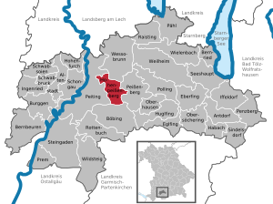
| County : | Weilheim-Schongau | |
| Height : | 780 m above sea level NHN | |
| Area : | 20.51 km 2 | |
| Residents: | 3853 (Dec. 31, 2019) | |
| Population density : | 188 inhabitants per km 2 | |
| Postal code : | 82383 | |
| Area code : | 08805 | |
| License plate : | WM, SOG | |
| Community key : | 09 1 90 130 | |
| LOCODE : | DE HPB | |
| Community structure: | 17 parts of the community | |
| Address of the municipal administration: |
Blumenstrasse 2 82383 Hohenpeißenberg |
|
| Website : | ||
| Mayor : | Thomas Dorsch (independent) | |
| Location of the community Hohenpeißenberg in the district of Weilheim-Schongau | ||
  |
||

Hohenpeißenberg is a municipality in the Weilheim-Schongau district in Upper Bavaria . The former mining site is located in the center of the Pfaffenwinkel . The landscape of the place is characterized by the almost 1000 meter high Hohen Peißenberg , the summit of which is located quite centrally in the local area and offers a beautiful view of the Alps. The pilgrimage church of the Assumption of Mary is a well-known place of pilgrimage and a popular destination for excursions. Today there is a transmission tower and a meteorological observatory on the mountain , which is considered the oldest mountain weather station in the world.
geography
location
Hohenpeißenberg is located in the Bavarian Oberland , in the foothills of the Alps . There is only the Hohenpeißenberg district .
The highest point of the place is the summit of the 988 meter high Hohen Peißenberg . Because of its overwhelming panoramic view, it is also called the “Bavarian Rigi ” or, much less often, “mons parnanssus ”. It is considered to be the most beautiful panoramic mountain in Bavaria and is a popular destination. The mountain's early nicknames were "mons doctus" because of its scholarship and meteorological research. Most of the inhabitants live on the south side of the mountain, another smaller part is on the west side (districts: Hetten and Buchschorn), a small proportion of the inhabitants is on the north and east sides.
The place is on the left bank of the Ammer River. The Ammer flows below the south side of the village, in a depression called "Schnalz".

Parish parts
The municipality has 17 officially named municipal parts .
![]() Map with all coordinates: OSM | WikiMap
Map with all coordinates: OSM | WikiMap
| Original church |
GTS 1 | Part of the community | Type | Population June 27, 1961 |
Population May 27, 1970 |
Population May 25, 1987 |
building | Apartments | Coordinates |
|---|---|---|---|---|---|---|---|---|---|
| Hohenpeissenberg | 001 | Hohenpeissenberg | Parish village | ... | ... | 3072 | 853 | 1292 | ... |
| Hohenpeissenberg | 002 | Bear cave | Wasteland | ... | ... | 8th | 2 | 3 | ... |
| Ammerhöfe | 003 | Bschorrwald | Village | 70 | 58 | ... 2 | ... 2 | ... 2 | 47 ° 47 '24 " N , 11 ° 1' 2.5" E |
| Hohenpeissenberg | 004 | Buchschorn | Wasteland | ... | ... | ... 2 | ... 2 | ... 2 | ... |
| Ammerhöfe | 005 | Fox hell | hamlet | 26th | 14th | 14th | 5 | 5 | 47 ° 47 '31.6 " N , 11 ° 1' 38" E |
| Ammerhöfe | 006 | Behind the scenes | hamlet | 17th | 17th | 12 | 4th | 5 | 47 ° 47 ′ 41.5 " N , 11 ° 1 ′ 56.7" E |
| Ammerhöfe | 008 | Mid-tail | Wasteland | 13 | 13 | 12 | 2 | 3 | 47 ° 47 '46.7 " N , 11 ° 2' 20" E |
| Ammerhöfe | 009 | Oberschwaig | Wasteland | 15th | 15th | 13 | 2 | 2 | 47 ° 48 '2.4 " N , 11 ° 2' 7.9" E |
| Ammerhöfe | 013 | Stone fall | Village | 85 | 70 | ... 2 | ... 2 | ... 2 | 47 ° 47 '36.2 " N , 11 ° 0' 49.4" E |
| Ammerhöfe | 014 | Substructure | settlement | 100 | 74 | ... 2 | ... 2 | ... 2 | 47 ° 47 '24.8 " N , 11 ° 1' 16.6" E |
| Ammerhöfe | 016 | Fore-tail | hamlet | 45 | 23 | 29 | 8th | 11 | 47 ° 47 '44.1 " N , 11 ° 2' 37.5" E |
| Ammerhöfe | 017 | Wörth | Wasteland | 6th | 6th | 2 | 3 | 47 ° 46 ′ 29 ″ N , 11 ° 2 ′ 6 ″ E |
Neighboring communities
Neighboring communities are Peiting (west), Peißenberg (east), Wessobrunn (north) and beyond the Schnalz in the south is Böbing .
climate
history
In 1514, residents built a chapel on the Hohe Peißenberg . A ducal nurse had a carved figure of Our Lady brought there from the Schongau castle chapel . This figure quickly gained the reputation of a miraculous image and a pilgrimage developed. At the beginning of the 17th century , a second church (the pilgrimage church) was therefore added, creating the current double church . The chapel is to the west of the church tower, the pilgrimage church itself to the east. The ensemble gives the summit of the mountain its typical silhouette.
Time of the Augustinian Canons
Augustinian canons of the Rottenbuch monastery supervised the pilgrimage up the mountain from 1604 until the secularization (expropriation of the monasteries) in 1803. The large ceiling fresco by Matthäus Günther in the chapel of grace on the mountain shows the handover of the pilgrimage site to the Rottenbuch monastery. The Augustinians also led the first meteorological observations. Practically uninterrupted meteorological observation series have existed since 1781, making it the oldest mountain weather station in the world. After the secularization, the pastor and the school teacher continued the measurements and records, and after the Second World War the German Weather Service took over the weather observation. The monks also ran a school on the mountain, the elementary school was founded by the Augustinian canon Primus Koch (1752-1812). Classes began in April 1802.
In the course of the administrative reforms in Bavaria , today's municipality was created with the municipal edict of 1818 . Before that, the area belonged to Peiting . Hohenpeißenberg belonged to the Munich Rent Office and to the Schongau Regional Court of the Electorate of Bavaria .
The first construction phase of the old, former school building on the mountain was built after the time of the monks from 1882 to 1883.
Mining
After residents discovered the local pitch coal deposits as early as the 16th century , there were initially isolated mining activities to a lesser extent. On May 8, 1837, state mining began with the attack on the main tunnel in the Brandach district. There are or were some old tunnels in the local area, and there are now guided tours in the main tunnel several times a year. From July 1, 1889, the substructure shafts were sunk. In order to be able to transport coal from the substructure shaft to the deep tunnel in Peißenberg, there was a 3.6 km long cable car from 1898 to 1928. The weather shaft at the train station in Hohenpeißenberg was sunk from 1937 to 1939, and from mid-October 1960 it was the deepest shaft in Bavaria at a depth of 1,150 meters. There was also a weather shaft in Klausen. The BHS stopped mining in the Peißenberger Mulde in 1968, first in Peiting and then in 1971 in Peißenberg. The closure of the Peißenberg mine meant the end of coal mining on the Hohen Peißenberg.
Until 1972, the district boundary of the former districts of Schongau and Weilheim ran through the current local area . Now the place is in the center of the new district of Weilheim-Schongau .
religion
The majority of the population is Catholic; at the last census in 1987, 85.1 percent were Roman Catholic and 10.7 percent were Protestant. The formerly independent Catholic parish was merged with the Peitinger parish a few years ago due to the lack of priests. There is now a priest who lives on site again.
dialect
In not everywhere equally typical is Bairisch as spoken in large parts of Upper and Lower Bavaria, especially on the north side of the mountain is still a slight coloring of Lech Rainer dialect noticeable touch of Bavarian and Alemannic language elements and characteristic of the area of the so-called Lech Rains is . The influence of the Alemannic dialect is already clearer in the neighboring town of Peiting, which historically belongs to the west. Historically, this goes back to the time after the retreat of the Romans, as this created a transition area between the Alemanni and Bavarians .
Incorporations
On January 1, 1978, parts of the area of the dissolved Ammerhöfe municipality were incorporated. Eastern parts of the community were previously Ammerhöfer area.
Population development
Between 1988 and 2018 the municipality grew from 3,265 to 3,855 by 590 inhabitants or 18.1%.
| year | 1840 | 1871 | 1900 | 1925 | 1939 | 1950 | 1961 | 1970 | 1987 | 1991 | 1995 | 2000 | 2005 | 2010 | 2015 |
| population | 374 | 646 | 1077 | 2103 | 2357 | 3575 | 3254 | 2986 | 3231 | 3617 | 3935 | 3984 | 3977 | 3813 | 3769 |
politics
mayor
| Term of office | mayor | Political party | Others |
|---|---|---|---|
| 1948-1960 | Konrad Heiss | SPD | Konrad Heiss was the first elected mayor after the Second World War in the town, which at that time was still dominated by mining. He was mayor of Hohenpeißenberg for two terms and did not run for reasons of age. |
| 1960-1988 | Ludwig Regau | SPD | |
| 1978-2008 | Karl Graf | CSU | |
| since 2008 | Thomas Dorsch | Non-party | Thomas Dorsch (* 1971) had been working in various administrative areas in the municipal administration since 1989. Since 2004 he has been the municipal treasurer and since 2005 he has taken on additional tasks of the manager. He has also been doing voluntary work for the Catholic parish for many years. |
Municipal council
| Party / list | Election 2014 | 2008 election | Election 2002 | |||
|---|---|---|---|---|---|---|
| % | Seats | % | Seats | % | Seats | |
| CSU | 51.3 | 8th | 43.6 | 7th | 49.4 | 8th |
| SPD | 18.5 | 3 | 17.3 | 3 | 30.6 | 5 |
| Free voters | 19.2 | 3 | 21.3 | 3 | 20.0 | 3 |
| Updraft e. V. | 11 | 2 | 17.8 | 3 | - | - |
| total | 100 | 16 | 100 | 16 | 100 | 16 |
| voter turnout | 60.9% | 75.5% | 72.2% | |||
Council taxes
The municipal tax revenue amounted to € 2,585,000 in 2011, of which the trade tax revenue (net) amounted to € 688,000.
Economy and Infrastructure
Public facilities
- Primus-Koch-Volksschule Hohenpeißenberg (elementary school), the new school building has been in use since the 1969/70 school year
- Two kindergartens:
- Catholic kindergarten at the parish church, since 1974
- Community kindergarten in the Hetten district, since 1993
- "House of clubs" in Hetten, since 1990
- Catholic public library in the rectory
Leisure and sports facilities
- Gym on school grounds
- Two soccer fields:
- Soccer field with soccer field at the clubhouse of TSV Hohenpeißenberg
- Football pitch at the Rigi-Alm
- Tennis courts at the Rigi Alm
- Bathing pond in the Hetten district, since around 2014
Ice hockey: From 1954 to 1978 there was also a successful ice hockey department at TSV Hohenpeißenberg that took part in the BEV's game operations . The greatest successes were the Bavarian State League Championship in 1976 and the associated promotion to the Bavarian League . In the period before that, the TSV team played in the fourth-class BLL for several years until 1968 . Source: rodi-db.de
traffic
Road traffic
The B 472 , which leads from Irschenberg to Marktoberdorf , runs through the southern part of the village . In earlier centuries, the main road ran essentially on the route of today's WM 13 district road on the north side of the Hohen Peißenberg and was mainly used for the transport of salt. This former salt road was also used by King Ludwig II when he traveled from Munich to Hohenschwangau to the two castles from what was then the end of the railway in Peißenberg . This salt road led from the Berchtesgadener Land into the Allgäu . The "Lower Salt Road" also ran through Huglfing, Peißenberg, Peiting and Schongau. In 1889 the new state road, which is also the current main road, was opened on the south side of the mountain.
From 2009 to 2017, a 5.5 kilometer long route of the bypass road on the southern outskirts was under construction, which was opened on December 18, 2017. This is the last section of the joint new route of the B 17 and B 472 with bypasses of Schongau, Peiting, Hohenpeißenberg and Peißenberg.
Rail transport
Also on the south side of the Hohen Peißenberg there is a small train station on the Schongau – Peißenberg railway line . Diesel multiple units of the Bavarian Regiobahn operate on this route every hour . Originally it was the wish of the community of Hohenpeißenberg to build the station at Schächen, which would not have been possible because of the steep incline from Peißenberg. That is why the station was built at a lower, more southern point. From 1937 the weather shaft at the station had its own siding. In addition, there was a warehouse on a stump track at the station until the 1950s . The loading track was there until the end of the 1970s and there was an intersection track until the 1990s , when the two trains from Weilheim and Schongau met in Hohenpeißenberg. Now the respective pairs of trains meet in Peißenberg. The actual station building used to have a loading ramp with storage space. Later, the building changed its appearance through a renovation, whereby the loading ramp was omitted. Today there is a covered shelter and a parking lot on the site.
Culture and sights

See also: List of architectural monuments in Hohenpeißenberg and List of ground monuments in Hohenpeißenberg
Museums
- Treasure chamber of Hohenpeißenberg, the highest museum (988 m) in the Pfaffenwinkel.
Buildings
- Hohenpeißenberg television tower , built in 1978 with a height of 158.76 m.
- Meteorological observatory with meteorological observations carried out since January 1, 1781 until today, making it the oldest mountain weather station in the world.
Churches
- Pilgrimage chapel and pilgrimage church “Mariä Himmelfahrt” with rococo frescos (1748) by Matthäus Günther , 1514 resp. Built at the beginning of the 17th century on the Hohen Peißenberg.
- The parish church "Resurrection of the Lord" with the laying of the foundation stone in 1960 in the town center on the south side of the mountain. The consecration took place on October 29, 1961 by the then Archbishop Cardinal Julius Döpfner .
- Small Evangelical Lutheran Gustav Adolf Church on Kreuzstrasse, corner of Sonnenstrasse; built in 1951
Chapels
- Hettenkapelle
- Small chapel in the Buchschorn
- Barbara Chapel in Hohenbrand
Regular events
Every year in summer there is a pilgrimage in traditional costume, along the mountain road up to the pilgrimage church.
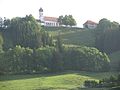
The summit of the Hohen Peißenberg with the pilgrimage church

Winter view of the mountain
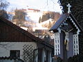
Hohenpeißenberg (south side) with the summit of the Hohen Peißenberg from Kreuzstrasse
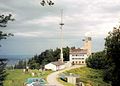
Meteorological observatory
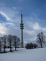
Television tower

The main tunnel in the Brandach district

Substructure tunnel before renovation

Pit substructure around 1900
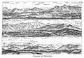
Alpine panorama from the Hohen Peißenberg (engraving, 1908)

The view of Hohenpeißenberg from the Hohen Peißenberg. Direction of view: to the south towards the Alps.

View of the Bahnhofstrasse

Town view from above

New parish church


Personalities
Honorary citizen
- Anton Pröbstl (1872–1957), miner, mayor and member of the state parliament
- Michael Zieglmeier (1874–1959), Senior Mountain Director
- Bernhard Baur (1920–1995), parish priest
Other personalities associated with the place
- Matthäus Günther (1705–1788), an important Rococo painter ; he was an altar boy in the pilgrimage church and painted the frescoes in the chapel of grace
- Primus Koch (born July 10, 1752 in Wolnzach ; † March 20, 1812 in Hohenpeißenberg), Augustinian canon, teacher, first parish priest
- Albin Schwaiger (born December 16, 1758 in Böbing ; † September 6, 1824 in Rottenbuch ), Augustinian canon, meteorological observer and researcher
- Karl Wilhelm Diefenbach (1851–1913), painter and life reformer; had a vision on February 10, 1882 on the Hohenpeissenberg under the impression of the sunrise that shaped his further uncompromising life as a pioneer of a new, ecologically oriented culture.
- Peter Graf (1874–1947), politician, second mayor of the municipality and member of the BVP state parliament
- Hermann Kätelhön (1884–1940), painter; Among other things, he created his “Hohenpeißenberg drawings” and was an important “mining painter” in the 1930s
- Hilger van Scherpenberg (1899–1969), diplomat and State Secretary; from 1937 he lived in the Hubertushof am Berg
- The opera singer couple, Ferdinand Frantz (1906-1959) and the soprano Helena Braun (born March 20, 1903 in Düsseldorf , † September 2, 1990 in Sonthofen ), had lived around 1950 in the district of Klausen.
- Jakob Mois (1907–1998), pastor and historian
- Karl Manninger (1912–2002), church painter; In 1987 he painted the ceiling painting in the Hetten Chapel
- Christine Stadler (1922–2001), sculptor and ceramicist; she created the interior of the new parish church, including the large mosaic
- Hubl Greiner (* 1955 in Hohenpeißenberg), musician
- Maximilian Nagl (* 1987), motocross driver; comes from Hohenpeißenberg
literature
- Max Biller and Local History Working Group: Hohenpeißenberger Heimat-Lexikon , publisher: Municipality of Hohenpeißenberg 1998
- Max Biller and Ludwig Stippel: Mining and Mining Museum on the Hohen Peißenberg. A guide through the history of mining in the Bavarian Rigi area. 3rd edition, 2006. Source: Association “Bergbaumuseumsfreunde Peißenberg e. V. "
- Felix Fischer (pastor): Description of the parish Hohenpeissenberg . Haas & Grabherr, Augsburg 1901
- Franz Hohenleithner: Small local history of Hohenpeissenberg . Hans Eiband, Hohenpeißenberg 1954
- Cornelia Lüdecke: 225 years of the Hohenpeißenberg meteorological mountain station . Naturwissenschaftliche Rundschau 59 (11), pp. 602-604 (2006), ISSN 0028-1050
- Georg Scherzl: House and farm history Hohenpeißenberg , publisher: Municipality of Hohenpeißenberg 2006
- Georg Scherzl: House and farm history Hohenpeißenberg. Volume 2 , editor: Hohenpeißenberg community 2009
- Peter Winkler: History of Meteorology in Germany, Hohenpeißenberg 1781 - 2006 - the oldest mountain observatory in the world . Self-published by the German Weather Service, Offenbach am Main 2006, ISBN 3-88148-415-9
- Peter Winkler: Early history of the Hohenpeißenberg mountain observatory: new findings and clarifications , German Weather Service, Offenbach am Main 2015, ISBN 978-3-88148-481-7
A bibliographic index of works on the place is in the Hohenpeißenberger Heimatlexikon , under the entry "Heimatschrifttum" on pp. 253-256.
Web links
- Entry on the coat of arms of Hohenpeißenberg in the database of the House of Bavarian History
- Website Meteorological Observatory Hohenpeißenberg with description of the observatory, current weather data and webcam
- Hohenpeißenberg: Official statistics of the LfStat (PDF; 1.24 MB)
References and comments
- ↑ "Data 2" sheet, Statistical Report A1200C 202041 Population of the municipalities, districts and administrative districts 1st quarter 2020 (population based on the 2011 census) ( help ).
- ^ Community Hohenpeißenberg in the local database of the Bavarian State Library Online . Bayerische Staatsbibliothek, accessed on September 4, 2019.
- ^ A b Hubert Assum, Leopold Mühlegger, Max Biller: School history. In: Max Biller: Hohenpeißenberger Heimat-Lexikon , page 468
- ↑ Hubert Assum, Leopold Mühlegger, Max Biller: School history. In: Max Biller: Hohenpeißenberger Heimat-Lexikon , page 471
- ^ A b Max Biller, Ludwig Stippel: Mining and Mining Museum on the Hohen Peißenberg , 3rd expanded edition from 2006, page 28
- ↑ network information for the workforce of the coal mine Peißenberg, Number 1, January 1961, page 6
- ↑ Max Biller, Ludwig Stippel: Bergbau und Bergbau-Museum am Hohen Peißenberg , 3rd expanded edition from 2006, page 33
- ↑ a b c Hohenpeißenberg municipal statistics , accessed on January 15, 2013
- ^ Federal Statistical Office (ed.): Historical municipality directory for the Federal Republic of Germany. Name, border and key number changes in municipalities, counties and administrative districts from May 27, 1970 to December 31, 1982 . W. Kohlhammer, Stuttgart / Mainz 1983, ISBN 3-17-003263-1 , p. 595 .
- ↑ cf. Hubert Assum, Max Biller: Mayor. In: Max Biller: Hohenpeißenberger Heimat-Lexikon , pages 164 to 166
- ↑ choice prospectus of mayoral candidate Thomas Dorsch for the local elections on March 2, 2008
- ^ Result of the 2014 local elections , accessed on March 18, 2014.
- ↑ Weilheimer Tagblatt of March 18, 2014, local section p. 8
- ↑ Local election Hohenpeißenberg 2008: Municipal Council (PDF; 58 kB), accessed on October 15, 2010
- ^ Result of the local elections in 2002 , accessed on October 22, 2010
- ↑ tsv-hohenpeissenberg.de Chronicle of TSV Hohenpeißenberg ( Memento of the original from February 20, 2015 in the Internet Archive ) Info: The archive link was inserted automatically and has not yet been checked. Please check the original and archive link according to the instructions and then remove this notice.
- ↑ ref rodi-db.de, TSV Hohenpeißenberg league membership
- ↑ sheet 780: Hohenpeißenberg. (JPG) In: The original position sheets of land surveying in Bavaria. Bayerische Landesbibliothek Online, 1859, accessed on November 18, 2017 .
- ^ A b c Max Biller: Road construction. In: Max Biller: Hohenpeißenberger Heimat-Lexikon , pages 496 to 497, with source reference to: Hubert Assum, Max Biller and Ernst Ursel
- ^ Georg Paula, Stefanie Berg-Hobohm: District Weilheim-Schongau: Monuments in Bavaria., Karl M Lipp Verlag Munich 2003, Volume 1, Page XVII, with references to: Riedl, Adrian von: Reiseatlas von Baiern , Vol. 1, Munich 1796–1805, map 39
- ^ Bayerischer Rundfunk: Opening of the bypass road ( memento of February 3, 2018 in the Internet Archive ), accessed on December 18, 2017
- ^ A b Peter Rasch: The branch lines between Ammersee, Lech and Wertach. With the Ammerseebahn, Pfaffenwinkelbahn & Co around the Bavarian Rigi . EOS Verlag, St. Ottilien 2011, 384 pages, color illustrations, ISBN 978-3-8306-7455-9 , p. 159 f
- ↑ a b c Peter Rasch: The branch lines between Ammersee, Lech and Wertach. With the Ammerseebahn, Pfaffenwinkelbahn & Co around the Bavarian Rigi . EOS Verlag, St. Ottilien 2011, ISBN 978-3-8306-7455-9 , pp. 181-184
- ↑ Georg Jocher, Jakob Mois , Max Biller: The pilgrimage church "Mariä Himmelfahrt". In: Max Biller: Hohenpeißenberger Heimat-Lexikon , pages 353 to 361
- ↑ Pastor Bernhard Bauer, Hubert Assum, Georg Suttner: The parish church "Resurrection our Lord Jesus Christ". In: Max Biller: Hohenpeißenberger Heimat-Lexikon , pages 362 to 367
- ^ Pastor Gerhard Schaller, Max Biller: The Evangelical Lutheran Gustav Adolf Church. In: Max Biller: Hohenpeißenberger Heimat-Lexikon , pages 368 to 372
- ^ Biography of the member of the House of Bavarian History , accessed on April 19, 2018
- ↑ a b c Max Biller: Honorary Citizen. In: Max Biller: Hohenpeißenberger Heimat-Lexikon , p. 178 f.
- ↑ a b Jakob Mois: Primus Koch: Augustinian canon of the Rottenbuch monastery and first pastor of Hohenpeißenberg (1752-1812). Schongau: Karl Motz & Co. Reprint from Lech- and Ammerrain: local supplement of the "Schongauer Nachrichten". 12th year 1967, No. 8
- ↑ a b c Peter Winkler: History of Meteorology in Germany, Hohenpeißenberg 1781 - 2006 - the oldest mountain observatory in the world ; Offenbach am Main 2006; Self-published by the German Weather Service, ISBN 3-88148-415-9 , page 150
- ^ Max Biller: Hohenpeißenberger Heimat-Lexikon , page 417
- ↑ George Scherzl: House and Court History Hohenpeißenberg , Publisher: Municipality Hohenpeißenberg 2006, page 57 f
- ↑ Helena Braun at Operissimo on the basis of the Great Singer Lexicon
- ↑ Braun, Helena. In: KJ Kutsch, L. Riemens: Großes Sängerlexikon , Volume 1, KG Saur, Munich 2003, ISBN 3-598-11598-9 , p. 573
- ↑ a b The Moralt Ring (English) , accessed on September 6, 2009, website operator: Andrea Suhm-Binder
- ↑ Max Biller: Hohenpeißenberger Heimat-Lexikon , page 427, with source reference to: Münchner Merkur, September 11, 1989, Michael Müller
- ^ Max Biller: Hohenpeißenberger Heimat-Lexikon , page 418
- ^ Max Biller: Hohenpeißenberger Heimat-Lexikon , page 417 f
- ↑ Weilheimer Tagblatt , July 6, 2011, page 1 and page 12 local section

Cities: Penzberg | Schongau | Weilheim in Upper Bavaria
Markets: Peißenberg | Peiting
Other municipalities: Altenstadt (Upper Bavaria) | Antdorf | Bernbeuren | Bernried am Starnberger See | Böbing | Burggen | Eberfing | Eglfing | Habach | Hohenfurch | Hohenpeissenberg | Huglfing | Iffeldorf | Ingenried | Oberhausen (near Peißenberg) | Obersöchering | Pähl | Polling (near Weilheim) | Prem | Raisting | Rottenbuch | Schwabbruck | Schwabsoien | Seeshaupt | Sindelsdorf | Steingaden | Wessobrunn | Wielenbach | Wildsteig