
Weilheim district in Upper Bavaria
| coat of arms | Germany map | |
|---|---|---|

|
Coordinates: 47 ° 50 ' N , 11 ° 8' E |
|
| Basic data (as of 1972) | ||
| State : | Bavaria | |
| Administrative region : | Upper Bavaria | |
| Administrative headquarters : | Weilheim i.OB | |
| Area : | 686.21 km 2 | |
| Residents: | 72,004 (May 27, 1970) | |
| Population density : | 105 inhabitants per km 2 | |
| License plate : | WM | |
| Circle key : | 09 1 55 | |
| Circle structure: | 42 municipalities | |
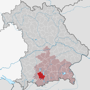
| Location of the district of Weilheim i.OB in Bavaria | ||
  |
||

The district of Weilheim in Upper Bavaria , officially the district of Weilheim i.OB , belonged to the Bavarian administrative district of Upper Bavaria . Before the beginning of the Bavarian regional reform, the district comprised 42 municipalities in the 1960s.
geography
Important places
The largest places were Weilheim i.OB , Penzberg , Murnau , Peißenberg and Polling .
Neighboring areas
Beginning in 1972, the district bordered clockwise in the north on the districts of Landsberg am Lech , Starnberg , Wolfratshausen , Bad Tölz , Garmisch-Partenkirchen and Schongau .
history
District Office
The district office of Weilheim followed in 1862 the area court of the older order of Weilheim .
On April 1, 1881, the Weilheim district office in Upper Bavaria was expanded to include the Raisting district of the Landsberg am Lech district office.
district
On January 1, 1939, the designation district was introduced as everywhere else in the German Reich . The district office became the Weilheim district in Upper Bavaria.
On July 1, 1972, the district was redesigned as part of the regional reform in Bavaria :
- The Schlehdorf community came to the Bad Tölz-Wolfratshausen district .
- The municipalities of Aidling , Großweil , Hechendorf, Kleinweil , Murnau , Riegsee , Schöffau, Seehausen am Staffelsee , Spatzenhausen , Uffing am Staffelsee and Weindorf came to the Garmisch-Partenkirchen district.
- All other municipalities were merged with the largest part of the dissolved district of Schongau and the municipality of Ingenried from the dissolved district of Marktoberdorf to form a new, larger district of Weilheim i.OB. On May 1, 1973, the district council established the current name of the Weilheim-Schongau district .
politics
District administrators
| Term of office | District Administrator | Political party |
|---|---|---|
| July 1, 1948 to August 24, 1962 (†) | Franz Josef Konrad | CSU |
| 1964 at the latest by June 30, 1972 | Georg Bauer | CSU |
Population development
| year | Residents | source |
|---|---|---|
| 1864 | 20,757 | |
| 1885 | 25,452 | |
| 1900 | 30,342 | |
| 1910 | 35,784 | |
| 1925 | 40,319 | |
| 1939 | 44,836 | |
| 1950 | 67,915 | |
| 1960 | 66,700 | |
| 1971 | 74,000 |
Communities
The municipalities of the district of Weilheim i.OB before the municipal reform (municipalities that still exist today are written in bold ):
The municipality of Penzberg was called Sankt Johannisrain until 1911 and the municipality of Peißenberg was called Unterpeißenberg until 1919 . The municipality of Arnried was incorporated into Eberfing on April 1, 1938 .
coat of arms
In 1964 the district adopted the following coat of arms : "In blue an upright silver abbot's staff, topped with a golden double knight, below with a silver mallet and silver hammer with an oblique crossing".
License Plate
On July 1, 1956, the district was assigned the distinguishing mark WM when the vehicle registration number that is still valid today was introduced . It is still issued in the Weilheim-Schongau district to this day.
Individual evidence
- ^ Official register of places for Bavaria 1964
- ^ Wilhelm Volkert (ed.): Handbook of Bavarian offices, communities and courts 1799–1980 . CH Beck, Munich 1983, ISBN 3-406-09669-7 , p. 591 .
- ^ Wilhelm Volkert (ed.): Handbook of Bavarian offices, communities and courts 1799–1980 . CH Beck, Munich 1983, ISBN 3-406-09669-7 , p. 97 .
- ^ Ordinance on the reorganization of Bavaria into rural districts and independent cities of December 27, 1971
- ^ Federal Statistical Office (ed.): Historical municipality directory for the Federal Republic of Germany. Name, border and key number changes in municipalities, counties and administrative districts from May 27, 1970 to December 31, 1982 . W. Kohlhammer, Stuttgart / Mainz 1983, ISBN 3-17-003263-1 , p. 595 .
- ^ Alfons Schmid: Chronicle of a district association for horticulture. 100 years of the District Association for Garden Culture and Land Care Weilheim-Schongau 1904–2004 . Ed .: District Association for Garden Culture and State Care Weilheim-Schongau eV 2004 ( Online [PDF; 2.4 MB ]).
- ^ Eugen Hartmann: Statistics of the Kingdom of Bavaria . Ed .: Royal Bavarian Statistical Bureau. Munich 1866, population figures of the district offices 1864 ( digitized version ).
- ↑ Royal Bavarian Statistical Bureau (ed.): Localities directory of the Kingdom of Bavaria . Munich 1888, population figures of the district offices 1885 ( digitized ).
- ↑ a b www.gemeindeververzeichnis.de
- ^ Localities directory for the Free State of Bavaria, based on the census of June 16, 1925
- ↑ Statistical Yearbook for the German Reich 1940
- ↑ Statistical Yearbook for the Federal Republic of Germany 1952
- ↑ Statistical Yearbook for the Federal Republic of Germany 1961
- ↑ Statistical Yearbook for the Federal Republic of Germany 1973
- ^ Michael Rademacher: German administrative history from the unification of the empire in 1871 to the reunification in 1990. District Weilheim i.OB. (Online material for the dissertation, Osnabrück 2006).
- ↑ BayernViewer of the Bavarian Surveying Administration (accessed on July 27, 2010)
- ↑ Reinhard Heydenreuter: The history of the district of Weilheim-Schongau . In: Georg Paula , Stefanie Berg-Hobohm : District Weilheim-Schongau (= Bavarian State Office for Monument Preservation [Hrsg.]: Monuments in Bavaria . Volume I.23 ). Lipp, Munich 2003, ISBN 3-87490-585-3 , pp. LXXVIII .
Aichach | Alzenau i.UFr. | Amberg | Bad Aibling | Bad Neustadt adSaale | Bad Toelz | Beilngries | Berchtesgaden | Bow | Brückenau | Burglengenfeld | Dingolfing | Dinkelsbühl | Donauwörth | Ebermannstadt | Boars | Eggenfelden | Erlangen | Eschenbach idOPf. | Feuchtwangen | Friedberg | Feet | Gemünden a.Main | Gerolzhofen | Grafenau | Griesbach i.Rottal | Gunzenhausen | Hammelburg | Hassfurt | Hersbruck | Hilpoltstein | Höchstadt adAisch | Hofheim i.UFr. | Illertissen | Ingolstadt | Karlstadt | Kaufbeuren | Kemnath | Kempten (Allgäu) | Königshofen i.Grabfeld | Kötzting | Krumbach (Swabia) | Landau adIsar | Lauf adPegnitz | Running | Lohr a.Main | Mainburg | Mallersdorf | Marktheidenfeld | Marktoberdorf | Mellrichstadt | Memmingen | Mindelheim | Münchberg | Nabburg | Naila | Neuburg adDonau | Neunburg vorm Wald | Neustadt adAisch | Nordlingen | Nuremberg | Obernburg am Main | Oberviechtach | Ochsenfurt | Parsberg | Pegnitz | Parish churches | Rehau | Riedenburg | Roding | Rothenburg ob der Tauber | Rottenburg adLaaber | Scheinfeld | Schongau | Schrobenhausen | Schwabach | Schwabmünchen | Sonthofen | Stadtsteinach | Staffelstein | Straubing | Sulzbach-Rosenberg | Uffenheim | Viechtach | Vilsbiburg | Vilshofen | Vohenstrauss | Waldmünchen | Wasserburg a.Inn | Wegscheid | Weilheim i.OB | Weißenburg i.Bay. | Wertingen | Wolfratshausen | Wolfstein
1939–1945 affiliated districts: Bergreichenstein | Eisenstein market | Prachatitz