Wakulla County
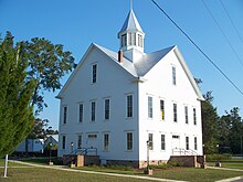
 Wakulla County Courthouse |
|
| National emblem | |
 seal |
|
| administration | |
|---|---|
| US state : | Florida |
| Administrative headquarters : | Crawfordville |
| Address of the administrative headquarters: |
County Courthouse P.O. Box 1263 Crawfordville, FL 32326-1263 |
| Foundation : | March 11, 1843 |
| Made up from: | Leon County |
| Area code : | 001 850 |
| Demographics | |
| Residents : | 30,776 (2010) |
| Population density : | 17 inhabitants / km 2 |
| geography | |
| Total area : | 1906 km² |
| Water surface : | 93 km² |
| map | |
| Website : www.wakullacounty.org | |
The Wakulla County is a county in the state of Florida of the United States . The county seat is Crawfordville .
history
Wakulla County was formed on March 11, 1843 from parts of Leon County. It was probably named after a word of the Timucua Indians and means something like "mysterious water".
Parts of the 1,936 designated National Forest Apalachicola National Forest extend County.
Geography & Landmarks
The county covers an area of 1906 square kilometers, of which 334 square kilometers are water. It is bordered in a clockwise direction by the following counties: Franklin County , Liberty County , Gadsden County , Leon County, and Jefferson County . Together with the counties of Gadsden, Jefferson and Leon, the county forms the metropolitan area of Tallahassee .
The county's most famous attraction is the Wakulla Springs , one of the largest freshwater springs in the world.
Demographic data
| growth of population | |||
|---|---|---|---|
| Census | Residents | ± in% | |
| 1850 | 1955 | - | |
| 1860 | 2839 | 45.2% | |
| 1870 | 2506 | -11.7% | |
| 1880 | 2723 | 8.7% | |
| 1890 | 3117 | 14.5% | |
| 1900 | 5149 | 65.2% | |
| 1910 | 4802 | -6.7% | |
| 1920 | 5129 | 6.8% | |
| 1930 | 5468 | 6.6% | |
| 1940 | 5463 | -0.1% | |
| 1950 | 5258 | -3.8% | |
| 1960 | 5257 | -0% | |
| 1970 | 6308 | 20% | |
| 1980 | 10,887 | 72.6% | |
| 1990 | 14,202 | 30.4% | |
| 2000 | 22,863 | 61% | |
| 2010 | 30,776 | 34.6% | |
| Before 1900
1900–1990 2000 + 2010 |
|||
As of the 2010 census , Wakulla County had 30,776 people in 12,851 households. The population density was 17 people per square kilometer. Ethnically, the population was composed of 82.0% white, 14.5% African American , 0.6% American Indian and 0.6% Asian Americans . 0.6% were members of other races and 1.8% of different races. 3.3% of the population was made up of Hispanics or Latinos .
In 2010 there were children under the age of 18 in 36.1% of all households and people aged 65 or over in 23.6% of all households. 72.4% of the households were family households (consisting of married couples with or without offspring or one parent with offspring). The average household size was 2.61 and the average family size was 3.03.
24.7% of the population were younger than 20 years, 27.4% were 20 to 39 years old, 31.3% were 40 to 59 years old, and 16.6% were at least 60 years old. The mean age was 39 years. 55.2% of the population were male and 44.8% were female.
The median income for a household in the 53,385 USD , while 14.1% of the population lived below the poverty line.
In 2010, English was the first language of 96.37% of the population, 2.31% spoke Spanish and 1.32% had another mother tongue.
Places in Wakulla County
Wakulla County towns and cities with 2010 census residents :
Cities :
- Crawfordville ( County Seat ) - 3,702 residents
- Panacea - 816 inhabitants
Web links
Individual evidence
- ↑ GNIS-ID: 306912. Retrieved on February 22, 2011 (English).
- ↑ US Census Bureau - Census of Population and Housing . Retrieved March 15, 2011
- ↑ Extract from Census.gov . Retrieved February 14, 2011
- ↑ Excerpt from census.gov (2000 + 2010) ( Memento of the original from February 13, 2014 in the Internet Archive ) Info: The archive link was automatically inserted and not yet checked. Please check the original and archive link according to the instructions and then remove this notice. Retrieved March 31, 2012
- ^ Profile of General Population and Housing Characteristics: 2010 . United States Census Bureau . Retrieved September 4, 2014.
- ↑ Language distribution 2010 . Modern Language Association . Archived from the original on August 15, 2013. Info: The archive link was inserted automatically and has not yet been checked. Please check the original and archive link according to the instructions and then remove this notice. Retrieved September 4, 2014.
Coordinates: 30 ° 9 ′ N , 84 ° 23 ′ W


