Charlotte County (Florida)
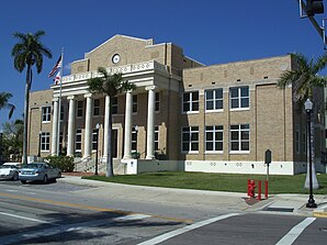
 Charlotte County Courthouse |
|
| National emblem | |
 seal |
|
| administration | |
|---|---|
| US state : | Florida |
| Administrative headquarters : | Punta Gorda |
| Address of the administrative headquarters: |
County Commissioners Administrative Complex 18500 Murdock Circle Port Charlotte, FL 33948 |
| Foundation : | April 23, 1921 |
| Made up from: | DeSoto County |
| Area code : | 001 941 |
| Demographics | |
| Residents : | 159,978 (2010) |
| Population density : | 89.1 inhabitants / km 2 |
| geography | |
| Total area : | 2225 km² |
| Water surface : | 429 km² |
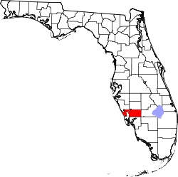
| map | |
| Website : www.charlottecountyfl.com | |
The Charlotte County is a county in the state of Florida of the United States . The county seat is Punta Gorda .
geography
The county is located in south-central Florida, borders the Gulf of Mexico to the west and has an area of 2225 square kilometers, of which 429 square kilometers are water. It is bordered in a clockwise direction by the following counties: Highlands County , Glades County , Hendry County , Lee County , Sarasota County, and DeSoto County .
The county is kept under the name Punta Gorda Metropolitan Statistical Area by the Office of Management and Budget for statistical purposes . With the adjacent metropolitan region of Sarasota and DeSoto County, the area is combined to form the CSA North Port-Sarasota .
history
Charlotte County was formed from DeSoto County on April 23, 1921 and named after Charlotte Harbor Bay .
Demographics
| growth of population | |||
|---|---|---|---|
| Census | Residents | ± in% | |
| 1930 | 4013 | - | |
| 1940 | 3663 | -8.7% | |
| 1950 | 4286 | 17% | |
| 1960 | 12,594 | 193.8% | |
| 1970 | 27,559 | 118.8% | |
| 1980 | 58,460 | 112.1% | |
| 1990 | 110,975 | 89.8% | |
| 2000 | 141,627 | 27.6% | |
| 2010 | 159,978 | 13% | |
| 1930–1990 2000 2010 | |||
According to the 2010 census, the then 159,978 inhabitants were distributed over 100,632 households. The population density was 89.1 inh / km². 90.0% of the population were white, 5.7% African American , 0.3% American Indian, and 1.2% Asian Americans . 1.1% were members of other races and 1.7% of different races. 5.8% of the population was made up of Hispanics or Latinos .
In 2010 children under 18 years of age and 50.2% of all households lived in 17.7% of all households with persons at least 65 years of age. 65.2% of the households were family households (consisting of married couples with or without offspring or one parent with offspring). The average household size was 2.14 people and the average family size was 2.57 people.
16.1% of the population were younger than 20 years, 14.5% were 20 to 39 years old, 25.8% were 40 to 59 years old, and 43.6% were at least 60 years old. The mean age was 56 years. 48.6% of the population were male and 51.4% were female.
The median annual income was $ 45,112, with 11.4% of the population living below the poverty line.
In 2000, English was the mother tongue of 90.72% of the population, 4.55% spoke Spanish and 4.73% had another mother tongue.
Educational institutions
- Edison College in Punta Gorda
Places in Charlotte County
Charlotte County localities with 2010 census population :
City :
- Punta Gorda ( County Seat ) - 16,641 inhabitants
- Charlotte Harbor - 3,714 residents
- Charlotte Park - 2,325 residents
- Cleveland - 2,990 residents
- Englewood - 14,863 residents
- Grove City - 1,804 residents
- Harbor Heights - 2,987 residents
- Manasota Key - 1,229 inhabitants
- Port Charlotte - 54,392 inhabitants
- Rotonda - 8,759 inhabitants
- Solana - 742 inhabitants
Web links
Individual evidence
- ↑ GNIS-ID: 295742. Retrieved on February 22, 2011 (English).
- ↑ CPH-T-5. Population Change for Metropolitan and Micropolitan Statistical Areas in the United States and Puerto Rico: 2000 to 2010. Retrieved April 4, 2016 .
- ↑ Extract from Census.gov . Retrieved February 14, 2011
- ↑ census.gov (2000) ( Memento of the original from April 25, 2012 in the Internet Archive ) Info: The archive link was inserted automatically and has not yet been checked. Please check the original and archive link according to the instructions and then remove this notice. ( MS Excel ; 26 kB) Accessed March 31, 2012
- ↑ Extract from census.gov (2010) Retrieved March 31, 2012
- ^ Profile of General Population and Housing Characteristics: 2010 . United States Census Bureau . Retrieved April 25, 2013.
- ↑ Language distribution 2000 . Modern Language Association . Retrieved April 25, 2013.
Coordinates: 26 ° 54 ′ N , 81 ° 57 ′ W


