Alachua County
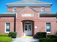
 Alachua County Courthouse |
|
| National emblem | |
 seal |
 flag |
| administration | |
|---|---|
| US state : | Florida |
| Administrative headquarters : | Gainesville |
| Address of the administrative headquarters: |
Alachua County Government 12 SE 1st Street Gainesville, Florida 32601 |
| Foundation : | December 29, 1824 |
| Made up from: |
Duval County St. Johns County |
| Area code : | 001 352 |
| Demographics | |
| Residents : | 247,336 (2010) |
| Population density : | 109.2 inhabitants / km 2 |
| geography | |
| Total area : | 2510 km² |
| Water surface : | 246 km² |
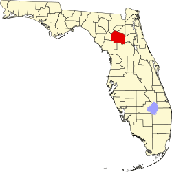
| map | |
| Website : www.alachua-county.org | |
The Alachua County is a county in the state of Florida of the United States . The county seat is Gainesville .
history
Alachua County was formed on December 29, 1824. The name comes from an Indian word that means something like "sinking hole". The administrative seat was Newnansville until 1854 before moving to Gainesville.
geography
The county has an area of 2510 square kilometers, of which 246 square kilometers are water. It is bordered clockwise by Clay County , Putnam County , Marion County , Levy County , Gilchrist County, and Columbia Counties . Together with Gilchrist County, the county forms the metropolitan area of Gainesville .
Demographic data
|
||||||||||||||||||||||||||||||||||||||||||||||||||||||||||||||||||||||||||||||||||||||||
As of the 2010 census , Alachua County had 247,336 people in 112,766 households. The population density was 109.2 inhabitants per square kilometer. Ethnically, the population was composed of 69.6% white, 20.3% African American , 0.3% American Indian and 5.4% Asian Americans . 1.8% were members of other races and 2.6% of different races. 8.4% of the population were Hispanics or Latinos .
In 2010 children under 18 years of age and 19.6% of all households lived in 24.8% of all households with persons at least 65 years of age. 53.2% of households were family households (consisting of married couples with or without offspring or one parent with offspring). The average household size was 2.32 people and the average family size was 2.91 people.
24.2% of the population were younger than 20 years, 37.1% were 20 to 39 years old, 22.9% were 40 to 59 years old, and 15.8% were at least 60 years old. The mean age was 30 years. 48.4% of the population were male and 51.6% were female.
The median income for a household in the 42,818 USD , while 23.8% of the population lived below the poverty line.
In 2010, English was the mother tongue of 86.43% of the population, 6.38% spoke Spanish and 7.19% had another mother tongue.
Further educational institutions
- Santa Fe Community College in Gainesville
- University of Florida at Gainesville
Attractions
Alachua County, especially the Gainesville area, is rich in attractions that are well worth a visit, such as B.
- The Archer Historical Society Railroad Museum , a former train station, built between 1857 and 1861 on the Fernandina Beach to Cedar Key railroad .
- The Dudley Farm in Dudley Farm Historic State Park in Newberry . A partly preserved farm from the 19th century.
- The Hawthorne Historical Museum in Hawthorne .
- The Haile Homestead , a mid-19th century cotton plantation. The Haile family wrote their story on the walls. More than 12,500 words in almost every room.
- The Marjorie Kinnan Rawlings Historic State Park in Cross Creek .
- The Matheson Museum in Gainesville
- The Micanopy Historical Society Museum in Micanopy .
- The Morningside Nature Center about 3 miles east of downtown Gainesville.
Places in Alachua County
Alachua County localities with 2010 census population :
Cities :
- Alachua - 9,059 inhabitants
- Archer - 1,118 inhabitants
- Gainesville ( County Seat ) - 124,354 residents
- Hawthorne - 1,417 residents
- High Springs - 5,350 residents
- Newberry - 4,950 residents
- Waldo - 1,015 inhabitants
Towns :
Islands
Web links
Individual evidence
- ↑ GNIS-ID: 308548. Retrieved on February 22, 2011 (English).
- ↑ US Census Bureau - Census of Population and Housing . Retrieved March 15, 2011
- ↑ Extract from Census.gov . Retrieved February 14, 2011
- ↑ census.gov (2000) ( Memento from April 25, 2012 in the Internet Archive ) ( MS Excel ; 26 kB) Retrieved on March 31, 2012
- ↑ Extract from census.gov (2010) Retrieved March 31, 2012
- ^ Profile of General Population and Housing Characteristics: 2010. United States Census Bureau , accessed February 17, 2014 .
- ^ Language distribution 2010. (No longer available online.) Modern Language Association , archived from the original on August 15, 2013 ; accessed on February 17, 2014 .
- ^ Archer Historical Society Railroad Museum ( Memento from June 3, 2009 in the Internet Archive )
- ^ Dudley Farm
- ↑ Hawthorne Historical Museum ( Memento from May 13, 2009 in the Internet Archive )
- ↑ Haile Homestead
- ^ Marjorie Kinnan Rawlings Historic State Park
- ↑ Link
- ^ Micanopy Historical Society Museum
- ^ Morningside Nature Center
Coordinates: 29 ° 41 ′ N , 82 ° 22 ′ W


