
Fesmy-le-Sart
| Fesmy-le-Sart | ||
|---|---|---|
|
||
| region | Hauts-de-France | |
| Department | Aisne | |
| Arrondissement | Vervins | |
| Canton | Guise | |
| Community association | Thiérache du Center | |
| Coordinates | 50 ° 3 ' N , 3 ° 41' E | |
| height | 137-192 m | |
| surface | 16.06 km 2 | |
| Residents | 486 (January 1, 2017) | |
| Population density | 30 inhabitants / km 2 | |
| Post Code | 02450 | |
| INSEE code | 02308 | |

Fesmy-le-Sart is a French municipality with 486 inhabitants (at January 1, 2017) in the Aisne department in the region of Hauts-de-France ; it belongs to the arrondissement of Vervins and the canton of Guise .
geography
Fesmy-le-Sart, the northernmost commune of the Aisne department, is located on the Upper Sambre and the Sambre-Oise Canal , about 35 kilometers northeast of Saint-Quentin and 35 kilometers southeast of Cambrai .
history
The municipality of Fesmy-le-Sart was created in 1807 through the merger of the municipalities of Fesmy and Le Sart. From 1830, the communities went their separate ways until they were merged again in 1972.
Population development
| year | 1962 | 1968 | 1975 | 1982 | 1990 | 1999 | 2008 | 2016 |
| Residents | 640 | 625 | 555 | 509 | 485 | 463 | 471 | 488 |
Attractions
The former Benedictine abbey of Saint-Étienne de Fesmy was founded in the 11th century and closed in 1763. Today the convent buildings serve as a farm and as a dwelling. The monastery church is used as a barn
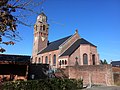
Saint Martin Church
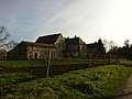
Saint-Etienne Abbey

