
Blankenheim (Ahr)
| coat of arms | Germany map | |
|---|---|---|
_COA.svg)
|
Coordinates: 50 ° 26 ' N , 6 ° 39' E |
|
| Basic data | ||
| State : | North Rhine-Westphalia | |
| Administrative region : | Cologne | |
| Circle : | Euskirchen | |
| Height : | 455 m above sea level NHN | |
| Area : | 148.62 km 2 | |
| Residents: | 8268 (Dec. 31, 2019) | |
| Population density : | 56 inhabitants per km 2 | |
| Postal code : | 53945 | |
| Primaries : | 02449, 02697 | |
| License plate : | EU, SLE | |
| Community key : | 05 3 66 008 | |
| LOCODE : | DE CKH | |
| Community structure: | 17 districts | |
| Address of the municipal administration: |
Rathausplatz 16 53945 Blankenheim |
|
| Website : | ||
| Mayor : | Rolf Hartmann (independent) | |
| Location of the community of Blankenheim in the Euskirchen district | ||
 |
||

Blankenheim is a municipality in North Rhine-Westphalia ( Germany ) in the Euskirchen district . The community, which has a good 8,000 inhabitants, is made up of 17 localities, of which the eponymous Blankenheim serves around 1,850 as their main residence. The main town of Blankenheim, as a state-approved resort, has a historic town center with a number of remarkable sights. Perhaps the best known is the Ahr spring , which is contained in a cellar vault of a half-timbered house from 1726. In the immediate neighborhood is the Eifelmuseum .
geography
Blankenheim is located about 27 kilometers southwest of the district town of Euskirchen on the western edge of the Ahr Mountains in the Eifel .
Community structure
Blankenheim consists of the following districts:
Neighboring communities
The municipality of Blankenheim is bounded clockwise to the west and north by the municipalities of Dahlem and Nettersheim, which are also located in the Euskirchen district . The state of Rhineland-Palatinate connects to the east and south . In detail, the municipal boundary in the east is shared with the association municipality of Adenau and here the municipalities of Hümmel , Ohlenhard , Aremberg , Dorsel and Müsch in the district of Ahrweiler . To the south follow the Vulkaneifel district the municipality Gerolstein with communities Nohn , Nohn and Wiesenbaum and Feusdorf and Esch .
climate
There is a mild climate for four months and a mild climate for eight months.
history
In the year 721 the name "blancium" is mentioned in the founding document for the Abbey of Prüm . In the opinion of some of the local historians active in local history, this is the first time that today's Blankenheimerdorf is mentioned in a document. The document says: "quidquid nobis obtingit de blancio". For example: "We bequeath all our property in Blancium to the monastery". "Blancio" is the ablative of "Blancium". Only later did the name Blankenheim change from the “village” on the height to the settlement in the “Dhal”. In the Eifel dialect they are called blangem .
As a result of the Peace of Lunéville , Blankenheim, like the rest of the Left Rhineland, came to France in 1801 and to Prussia in 1815 through the resolutions of the Congress of Vienna . Graf Sternberg Manderscheid received in Reichsdeputationshauptschluss 1,803 for the loss of Blankenheim, Jünkerath, Gerolstein and Dolldorf as compensation, among others, the estates of former monasteries Weißenau and Schussenried in Upper Swabia awarded.
Witch trials in Blankenheim
In 1614, 14 people were tried in witch trials in Blankenheim, 12 women and two men were burned. From 1627 to 1633 further witch hunts took place. The Cologne witch judge Dr. jur. Johannes Möden was feared as a witch hunter of that time. In 1627 alone he sentenced 30 people in Blankenheim who were burned at the stake.
Religions
The area of the community Blankenheim has been catholic from the start. Some of the parishes are more than 700 years old, with the parish of Blankenheim belonging to the Archdiocese of Cologne until 1801 as part of the Eifel deanate . Here, too, the Peace of Lunéville initially led to a change. Blankenheim was assigned the main parish in the canton of Blankenheim of the same name and the newly established diocese of Aachen . It remained with this until its dissolution in 1821, but did not come back to the Archdiocese of Cologne until 1825, now as the capital of the newly formed dean's office in Blankenheim . The latter essentially comprised the area of today's municipalities Blankenheim and Dahlem including Udenbreth. From 1925 to 1973, the church of Dahlem formed its own district as the Kronenburg deanery, and Udenbreth was incorporated into the Hellenthal deanery during this reform. When the diocese of Aachen was re-established in 1930, the Schleiden district and thus also Blankenheim became part of it. The Deanery Blankenheim-Kronenburg, which has existed again since 1973, was later renamed Blankenheim-Dahlem. Ten of the 15 parishes of the deanery are located in the Blankenheim area: Alendorf, Blankenheim, Blankenheimerdorf, Dollendorf, Lommersdorf, Mülheim, Reetz, Ripsdorf, Rohr and Uedelhoven. Due to the lack of pastors and the declining number of members of the Roman Catholic Church, they are now administered by the Blankenheim parish association. The local parish offices and rectories are largely orphaned.
In addition to the Catholic Church, there has been a United Evangelical Church Congregation ( Lage ) since 1956 . Especially in the years after the Second World War , due to the high number of refugees from Pomerania, Silesia and East Prussia, numerous Protestants came to the Eifel temporarily, many of whom settled permanently. In 1955/56 a parish church and a small parish hall could be built in Blankenheim, which is the second parish of the Protestant parish of Roggendorf . The parish looks after the residents of the communities Blankenheim, Dahlem and Nettersheim.
The Free Christian Community of Blankenheim ( Lage ) was formed not least as a result of the dissolution of the Soviet Union , when a large number of Russian Germans found a new home in Blankenheim in the 1990s .
In Blankenheim there is the Fatih Camii mosque, which is part of the DITIB umbrella organization .
Neither a synagogue congregation nor an Israelite cemetery was found in the community area. Few Jewish families settled in the area before 1933. After fleeing and expulsion, Jewish life was completely extinct after May 8, 1945 .
Incorporations
On July 1, 1969, the former communities of Ahrdorf, Alendorf, Blankenheimerdorf, Dollendorf, Freilingen, Hüngersdorf, Lindweiler, Lommersdorf, Mülheim, Reetz, Ripsdorf, Rohr, Uedelhoven and Waldorf were incorporated.
politics
Municipal council
The municipal council is the municipal representative of the community of Blankenheim. The citizens decide on the composition every five years. The last election took place on May 25, 2014.
mayor
Rolf Hartmann was elected mayor in 2004 and re-elected in 2009 and 2015.
partnership
Blankenheim is Zaventem in the Belgian Flanders twinned .
Coat of arms and banner
coat of arms
|
|
Blazon : "The coat of arms shows in gold (yellow) a red armored and tongued black lion, topped above the middle with a free-floating, five-legged red tournament collar." |
| Justification of the coat of arms: The coat of arms shows the heraldic animal of the Counts of Blankenheim . It is modeled on a jury's seal from the 16th century. |
The municipality of Blankenheim was granted the right to use a coat of arms, a seal and a flag (banner) in a certificate from the regional president in Aachen dated September 8, 1971.
banner

banner
"The flag (banner) is black - yellow - black in a ratio of 1: 4: 1 striped lengthways with the municipal coat of arms without a shield slightly above the middle."
Culture and sights

House in Blankenheim
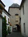
Shepherd's Tower

St. Mary of the Assumption
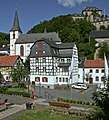
Parish Church and Blankenheim Castle

Interior view of the parish church

Carving in the church; Detail of a pew

Saint John
Museums
- Eifelmuseum Blankenheim , regional museum for natural history and cultural history of the north / west Eifel
- Blankenheim Carnival Museum in Georgstor
- Natural history exhibition in the shepherd's tower
Buildings
Blankenheim Castle from the 12th century is located above the village . Today it is used as a youth hostel . Structural changes were made in the course of the takeover of government by the Counts of Manderscheid at Blankenheim Castle in 1468. Count Dietrich III. had a long-distance water supply set up for the castle, which had to be led in a tunnel under the "Tiergarten" mountain in order to maintain the gradient. The tunnel is the only known of the late Middle Ages in all of Europe. The massive structure of the castle dominates the image of Blankenheim.
The medieval town center offers remains of the fortifications (shepherd's tower, from the 16th century and the Georgstor from the second half of the 17th century), numerous half-timbered buildings and the parish church of St. Mary of the Assumption (completed in 1505). The listed Kreuzkapelle is also worth seeing .
The Roman villa Blankenheim ( Lage ) is located northwest of the town center on the In der Alzen street . The manor complex, which was managed from the end of the first to the fourth century AD, stretched around 250 by 120 meters over an area of around three hectares . After a first excavation at the end of the 19th century and further archaeological investigations in the period from 1914 to 1931, the complex was made accessible to the public by July 2014.
tourism
- In the historic center of Blankenheim, the source of the Ahr ( 50 ° 26 ′ 17 ″ N , 6 ° 38 ′ 58 ″ E ) is captured in the cellar of a half-timbered house.
- Tiergarten tunnel hiking trail with historic Tiergarten tunnel (hiking route with 2 × 9.5 km)
- Blankenheim is the starting point of the AhrSteig long-distance hiking trail over the heights to the confluence of the Ahr and the Rhine near Sinzig .
- The Eifel-Höhen-Route cycle path leads through the village and this is where the 90 km long Ahr cycle path starts , which runs along the Ahr to its confluence with the Rhine at Sinzig . It is also part of the valley route , which connects interesting tourist destinations in the Euskirchen district via family-friendly routes.
- The famous Nürburgring is approx. 30 km away.
- Carnival in Blankenheim

prince

Carnival procession

Jecke beans

Regular events
- Carnival : the Rose Monday procession and the Blankenheim ghost procession on Carnival Saturday
- Summer at the lake: live music, activities and a children's program every Thursday in July
- Tour de Ahrtal: Car-free Ahrtal from Blankenheim to Dümpelfeld, action points along the route, annually in June
Economy and Infrastructure
traffic
Rail transport / public transport
Since the closure of the Ahrdorf – Blankenheim railway line , the only train station in the municipality is now away from the main town of Blankenheim, on the Eifel line : Blankenheim-Wald . From there there are hourly connections in the direction of Euskirchen - Cologne - Cologne Messe / Deutz / Bonn and Bad Münstereifel , the latter with a change in Euskirchen and to Gerolstein - Trier .
The connection to the station takes place with the buses of the RVK . From the bus station opened in December 2006 on the northern edge of the main town, there are further connections to the districts, as well as to Bad Münstereifel and the community of Dahlem .
Except for school trips, the so-called taxi bus is mainly used; a trip is only possible after prior telephone appointment. The tariff of the Verkehrsverbund Rhein-Sieg applies , as well as the NRW tariff across the network .
Streets
Bundesautobahn 1 of the Eifelautobahn from the north ends at the local junction in Blankenheim . There is a 26 km long interruption until the restart of the motorway near Kelberg in a southerly direction , the gap closing of which is listed as an urgent requirement in the federal transport route plan.
The federal highways 258 lead through the municipality in a west-east direction and 51 ( bypass ) in a north-south direction. Before the extension of the Blankenheim bypass, they found their intersection in the center of the village, which is now west of Blankenheimerdorf.
The place is on the old Roman road Trier-Neuss .
Established businesses
In addition to hotels, restaurants and several campsites (Ahrdorf and Freilingen), the municipality mainly has small businesses, handicrafts and the retail businesses required for local supplies.
In 1973/74 a commercial area was developed north of Blankenheim with a connection to the federal highway 51, which was expanded again in 1993, 1996 and 2005 to a gross area of about 45 hectares . There, but partly also in the associated districts such. B. Ahrhütte (including car dealers) or Freilingen (agricultural machinery) are medium-sized companies from the construction, machine and agricultural machinery or food sector.
education
The municipality of Blankenheim has the following school facilities, partly in partnership with the neighboring municipality of Nettersheim:
- Primary school association with the main location in Blankenheim and a sub-location in Dollendorf
- Open all-day school
- Nettersheim community secondary school in Nettersheim
- Realschule Blankenheim - this expires with the school year 2017/18.
- Comprehensive School Blankenheim – Nettersheim - starting with the 2013/14 school year
In addition, there is a Catholic kindergarten in Blankenheim (Hülchrath) and kindergartens in Dollendorf, Lommersdorf, Mülheim and Ripsdorf, which are maintained by the DRK , and a family center in Blankenheim.
Born in Blankenheim
- Hermann von Manderscheid-Blankenheim (1535–1604) was Count von Manderscheid-Blankenheim, Lord of Jünkerath, Erp and Daun
- Franz-Josef Heyen (1928–2012), archivist, historian and philologist
- Benedikt Reetz OSB (1897–1964), as Benedictine abbot of Seckau Abbey and Archabbot of Beuron Archabbey
- Dominic Sanz (* 1991), pop singer
See also
- County of Manderscheid , Count of Manderscheid-Blankenheim
- List of natural monuments in Blankenheim
literature
- Johannes Becker: History of the parishes of the deanery Blankenheim . Cologne 1893 (new edition Aachen 2004). ISBN 3-8322-3368-7
- Christoph Bungartz , Ralf Gier, Peter Scheulen: From the Eifel to America. Emigration to the Oberahr area 1840–1914 . Euskirchen 2005. ISBN 3-935221-55-X
- Harry Heindrichs: The history of the Blankenheim counts . Blankenheim 1978.
- Gerd J. Nettersheim (Ed.) On behalf of the Vereinkartell Blankenheim e. V .: 900 years of Blankenheim. From the count's residence to the modern community. Self-published, Blankenheim 2015, ISBN 978-3-00-049892-3
- Peter Neu: Blankenheim. In: Rheinischer Städteatlas . Delivery II No. 11, Bonn 1974. ISBN 3-7928-0361-5
- Karl Otermann: Brighten up your home. A decade in the service of the local history of Blankenheim, Blankenheimerdorf and the surrounding area . Collected and reissued by Peter Baales. Blankenheimerdorf 2004.
- Ernst Wackenroder : The art monuments of the Schleiden district , Düsseldorf 1932, pp. 48–88
Web links
Individual evidence
- ↑ Population of the municipalities of North Rhine-Westphalia on December 31, 2019 - update of the population based on the census of May 9, 2011. State Office for Information and Technology North Rhine-Westphalia (IT.NRW), accessed on June 17, 2020 . ( Help on this )
- ↑ Peter Baales: The hex must burn. Witches madness in the county of Blankenheim. (PDF; 662 kB), accessed on May 9, 2016.
- ↑ Names of the victims of the witch trials / witch persecution in Blankenheim and from the Schüller area (PDF; 1.3 MB), accessed on May 9, 2016.
- ↑ Pfarrverbund Blankenheim, ( Memento from December 22, 2015 in the Internet Archive ) accessed on December 17, 2015.
- ↑ parish Blankenheim, on ev-kirchengemeinde-roggendorf.de, accessed December 17, 2015.
- ↑ Freie Christengemeinde Blankenheim, on neue-leben-blankenheim.de, accessed on December 17, 2015.
- ↑ Martin Bünermann: The communities of the first reorganization program in North Rhine-Westphalia . Deutscher Gemeindeverlag, Cologne 1970, p. 99 f .
- ↑ Blankenheim community. European / Local elections 2014. May 25, 2014, accessed on November 4, 2014 .
- ↑ Main statute of the municipality of Blankenheim, § 2. Accessed on December 31, 2012 .
- ^ Römervilla Blankenheim ( Memento from June 20, 2015 in the web archive archive.today ) Retrieved on December 19, 2015.
- ^ Exposé of the Blankenheim community, ( Memento from December 22, 2015 in the Internet Archive ), accessed on December 17, 2015.
Ahrdorf | Ahrhütte | Alendorf | Blankenheim | Blankenheimerdorf | Blankenheim Forest | Dollendorf | Freilingen | Hüngersdorf | Lindweiler | Lommersdorf | Mülheim | Nonnenbach | Reetz | Ripsdorf | Pipe | Uedelhoven | Waldorf
Bad Münstereifel | Blankenheim | Dahlem | Euskirchen | Hellenthal | Kall | Mechernich | Nettersheim | Schleiden | Weilerswist | Zülpich