California State Route 1

|
||||||||||||||||||||||||||||||||||||||||||||||||||||||||||||||||||||||||||||||||||||||||||||||||||||||||||||||||||||||||||||||||||||||||||||||||||||||||||||||||||||||
|---|---|---|---|---|---|---|---|---|---|---|---|---|---|---|---|---|---|---|---|---|---|---|---|---|---|---|---|---|---|---|---|---|---|---|---|---|---|---|---|---|---|---|---|---|---|---|---|---|---|---|---|---|---|---|---|---|---|---|---|---|---|---|---|---|---|---|---|---|---|---|---|---|---|---|---|---|---|---|---|---|---|---|---|---|---|---|---|---|---|---|---|---|---|---|---|---|---|---|---|---|---|---|---|---|---|---|---|---|---|---|---|---|---|---|---|---|---|---|---|---|---|---|---|---|---|---|---|---|---|---|---|---|---|---|---|---|---|---|---|---|---|---|---|---|---|---|---|---|---|---|---|---|---|---|---|---|---|---|---|---|---|---|---|---|---|---|
| map | ||||||||||||||||||||||||||||||||||||||||||||||||||||||||||||||||||||||||||||||||||||||||||||||||||||||||||||||||||||||||||||||||||||||||||||||||||||||||||||||||||||||

|
||||||||||||||||||||||||||||||||||||||||||||||||||||||||||||||||||||||||||||||||||||||||||||||||||||||||||||||||||||||||||||||||||||||||||||||||||||||||||||||||||||||
| Basic data | ||||||||||||||||||||||||||||||||||||||||||||||||||||||||||||||||||||||||||||||||||||||||||||||||||||||||||||||||||||||||||||||||||||||||||||||||||||||||||||||||||||||
| Overall length: | 655 mi / 1055 km | |||||||||||||||||||||||||||||||||||||||||||||||||||||||||||||||||||||||||||||||||||||||||||||||||||||||||||||||||||||||||||||||||||||||||||||||||||||||||||||||||||||
| Starting point: |
|
|||||||||||||||||||||||||||||||||||||||||||||||||||||||||||||||||||||||||||||||||||||||||||||||||||||||||||||||||||||||||||||||||||||||||||||||||||||||||||||||||||||
| End point: |
|
|||||||||||||||||||||||||||||||||||||||||||||||||||||||||||||||||||||||||||||||||||||||||||||||||||||||||||||||||||||||||||||||||||||||||||||||||||||||||||||||||||||
| Counties: |
Mendocino Sonoma Marin San Francisco San Mateo Santa Cruz Monterey San Luis Obispo Santa Barbara Ventura Los Angeles Orange |
|||||||||||||||||||||||||||||||||||||||||||||||||||||||||||||||||||||||||||||||||||||||||||||||||||||||||||||||||||||||||||||||||||||||||||||||||||||||||||||||||||||
|
course
|
||||||||||||||||||||||||||||||||||||||||||||||||||||||||||||||||||||||||||||||||||||||||||||||||||||||||||||||||||||||||||||||||||||||||||||||||||||||||||||||||||||||
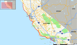
The California State Route 1 (short- CA 1 ), and Highway 1 called, is running in a north-south direction State Route in the US state of California , which on the coast of the Pacific Ocean runs. The road is a connection between Southern California and Northern California , along the course of which also lie the major cities of Los Angeles and San Francisco . As it passes one of the most beautiful stretches of coast in the country, it is designated as a National Scenic Byway . Some sections also have nicknames, such as the Pacific Coast Highway ( PCH for short ), Cabrillo Highway or Shoreline Highway . At 655 miles (1,055 km), the highway is the longest state route in the state of California. The road is part of the California Freeway and Expressway System .
CA 1 begins on Interstate 5 at Dana Point before heading north through the western suburbs of Los Angeles. The road crosses the coastal cities of Newport Beach , Santa Monica and Malibu . In the following section, the highway runs roughly parallel to US Highway 101 . Shortly after Santa Barbara it leads back to the sea. The most scenic section begins north of Morro Bay . The road leads along the cliffs of Big Sur as far as Monterey . From Monterey it follows the coastline via Santa Cruz to San Francisco. After crossing the Golden Gate Bridge , the highway follows the seashore again and ends a few miles before Garberville on 101.
course
In Southern California , the section between the cities of Dana Point and Oxnard is officially designated as the Pacific Coast Highway . From Buellton to Pismo Beach and from San Luis Obispo to San Francisco , CA 1 is officially known as the Cabrillo Highway . On the northernmost section between Marin City and the end point near the village of Garberville , it is officially designated as a Shoreline Highway . The entire route is also nicknamed the Blue Star Memorial Highway in memory of the members of the armed forces of the United States . A section at Big Sur is registered as a National Scenic Byway . In addition, many municipalities have given the street other local names.
Orange County
At its southern endpoint, CA 1 crosses Interstate 5 (San Diego Freeway) at San Juan Capistrano in Orange County . Under the name Pacific Coast Highway , the route runs north through the town center of Dana Point , where it splits into two one-way streets for around a mile (1.6 km). Within sight of the Pacific Ocean , the highway runs through the artist colony of Laguna Beach and Crystal Cove State Park .

CA 1 then crosses the well-known coastal town of Newport Beach , where it is signposted as the Coast Highway. It runs through several affluent neighborhoods, including Newport Coast and Corona del Mar , among others . In the center of town, the road crosses Newport Bay , which is used as an anchorage for numerous luxury yachts. Shortly afterwards the Santa Ana River is crossed. At Huntington Beach , the name changes back to Pacific Coast Highway. There it passes Huntington State Beach and the Bolsa Chica Ecological Reserve . The highway continues along the coast through Seal Beach , where Orange County is finally left.
Los Angeles and Ventura Counties
Beyond the Los Angeles County border , the Pacific Coast Highway swings a few miles inland in Long Beach , where it reaches the junction with California State Route 19 (Lakewood Boulevard). In a westerly direction, Wilmington and Harbor City are two districts of the huge metropolis Los Angeles as well as the cities of Lomita and Torrance . The course of the road then continues in a northerly direction through Redondo Beach and Hermosa Beach . In the urban area of Manhattan Beach , CA 1 briefly runs on the route from Sepulveda Boulevard to El Segundo . At the height of Los Angeles International Airport (LAX), it passes under two taxiways of the airport.

After the airport, CA 1 becomes Lincoln Boulevard, which runs through Marina del Rey and Venice , among other places . At Santa Monica , the highway splits for a few miles with Interstate 10 (Santa Monica Freeway). After exiting the McClure tunnel , it comes to light on the Santa Monica beach promenade and from now on follows the course of the sea coast again. Referred to again as the Pacific Coast Highway, the road in Pacific Palisades curves in a westerly direction, where the Getty Villa is passed shortly before Malibu .

North of Malibu, the highway reaches Ventura County , where it first touches Point Mugu State Park . A cut of the coastal mountains is crossed, which form the Point Mugu . The roadside cone-shaped rock formation that towers over the Pacific Ocean is known as Point Mugu Rock . At this point, the CA 1 leaves the coast to the north, in order to then pass the Naval Air Station Point Mugu . After a few miles, it meets the city of Oxnard , where it crosses California State Route 232 under the name Oxnard Boulevard . For a short distance, the Pacific Coast Highway joins US Highway 101 for the first time .
Central Coast and Big Sur
Behind Ventura , CA 1 separates from US Highway 101 for the time being, only to reunite with it a few miles before the Santa Barbara County border . For the next 54 miles (87 km), the two highways share a common route that runs through Santa Barbara . CA 1, now known as the Cabrillo Highway , leaves the US 101 north of the Gaviota tunnel . The Vandenberg Air Force Base grounds extend several miles west of the road. After crossing the coastal towns of Lompoc , Guadalupe and Grover Beach , she meets US 101 for the third time in Pismo Beach .

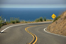
Further inland in San Luis Obispo , the US 101 leaves the common route again, while the CA 1 continues to cross San Luis Obispo County as the Cabrillo Highway . In the small coastal town of Morro Bay , an old Chumash Indian settlement is passed. From Cayucos the highway becomes a winding two-lane country road. It follows the coastline through San Simeon to the cliffs of Big Sur , where the sea extends several meters deeper. In this section, the road winds along the slopes of the Santa Lucia Mountains , which are part of the California Coast Mountains . Near San Simeon, Hearst Castle can be seen from the road, perched high on a hilltop. There are five in the Art Deco held prestressed - arch bridges crosses, of which the Bixby Bridge with a span of 98 meters and the Rocky Creek Bridge are the two largest. This scenic section from San Simeon to Carmel-by-the-Sea is designated as a National Scenic Byway .
After passing through Carmel-by-the-Sea , the road widens again to several lanes near Monterey . There is a connection to the famous 17-Mile Drive . Then the Monterey County and shortly thereafter the Santa Cruz County are crossed. From the junction with California State Route 156 , CA 1 continues north as a two-lane country road. It meets California State Route 17 in the city of Santa Cruz . In the town center, the street runs as Mission Street and Coast Road before being renamed Cabrillo Highway again.
San Francisco Bay Area
Moving further north, CA 1 reaches the San Francisco Peninsula and picturesque Half Moon Bay . A few miles before the small town of Pacifica in San Mateo County , Devil's Slide passes a steep drop-off point above the sea. Since there is a risk of the road slipping into the Pacific Ocean during storms , the roadway has to be closed frequently. To circumvent this problem, it was decided to build a tunnel, which should be opened in 2011.
Behind Pacifica, the highway widens into a multi-lane freeway, before splitting the route with Interstate 280 (Junipero Serra Freeway) for several miles in Daly City . On the San Francisco border , CA 1 changes its name to Junipero Serra Boulevard. Shortly afterwards, it makes a slight left turn and widens to the six-lane 19th Avenue. After passing the Golden Gate Park and the Presidio , the street becomes Park Presidio Boulevard and finally leads into the MacArthur Tunnel . It joins US Highway 101 for the fourth time near the Golden Gate Bridge . The two streets share the famous suspension bridge for crossing the strait at the Golden Gate , which forms the entrance to San Francisco Bay .
In the Redwood Empire

With the passage of the Golden Gate Bridge, CA 1 leaves San Francisco County on the way to Marin County . The area north of the bay is often referred to as the Redwood Empire . The US 101 leaves the joint route near the town of Marin City . Now under the name Shoreline Highway , the CA 1 again takes a narrow and winding road to cross the Marin Hills . At Muir Beach it reaches the seashore again. After leaving the Golden Gate National Recreation Area , the highway passes the scenic Point Reyes National Seashore and Tomales Bay . At the height of Bodega Bay , made famous by the film The Birds (1963), the road finally reaches Sonoma County . There it changes its name to Coast Highway.
The CA 1 meanders along the rugged coastline, then crosses the Gualala River and the border with Mendocino County . In Point Arena , the highway briefly becomes Main Street before following School Street in a north-westerly direction and reassigning the name Shoreline Highway. The last major town on the street is Fort Bragg , where it is known as Main Street. Heading further north, it follows the coastline for around 30 miles (48 km). The CA 1 then swings inland and runs through a hilly forest area that is predominantly overgrown by huge redwood trees. It finally ends after about 655 miles (1055 km) near the small town of Leggett at the junction with US Highway 101 .

literature
- Paula Almquist , Photos: Jürgen Schmitt: California: The coast of dropouts. In: Geo-Magazin. Hamburg 1979, 9, pp. 64-92. Informative experience report. ISSN 0342-8311
See also
Web links
- California @ AA Roads - route description with photos
- California Highways History and Information
- Highway 1 in California - route description with sights (German)
Individual evidence
- ↑ Streets and Highways Code Section 250-257. (No longer available online.) Official California Legislative Information, archived from the original on October 14, 2012 ; accessed on May 21, 2009 . Info: The archive link was inserted automatically and has not yet been checked. Please check the original and archive link according to the instructions and then remove this notice.
- ↑ a b c d 2014 Named Freeways, Highways, Structures and Other Appurtenances in California. (PDF; 2.12 MB) California Department of Transportation, accessed January 15, 2016 .
- ↑ a b Route 1 - Big Sur Coast Highway. Federal Highway Administration, accessed January 15, 2016 .
- ↑ Morro Creek. megalithic.co.uk, accessed October 9, 2009 .
- ^ David McCallen, Charles Noble, Matthew Hoehler: The Seismic Response of Concrete Arch Bridges. (PDF) June 1999, p. 12 , accessed on December 1, 2013 (English).
- ↑ Caltrans District 4 Devil's Slide Project. California Department of Transportation, accessed October 10, 2009 .


