
Eisbach (Rhine)
|
Eisbach (also the Eis , on the Unterlauf Altbach ) |
||
 Course of the river Eisbach (above) |
||
| Data | ||
| Water code | DE : 23918 | |
| location |
Palatinate Forest
Rhenish Hessian table and hill country |
|
| River system | Rhine | |
| Drain over | Rhine → North Sea | |
| source |
Hohe Bühl near Ramsen 49 ° 29 ′ 54 ″ N , 7 ° 59 ′ 10 ″ E |
|
| Source height | approx. 290 m above sea level NHN | |
| muzzle | in Worms in the Rhine Coordinates: 49 ° 37 ′ 23 " N , 8 ° 22 ′ 55" E 49 ° 37 ′ 23 " N , 8 ° 22 ′ 55" E |
|
| Mouth height | 89 m above sea level NHN | |
| Height difference | approx. 201 m | |
| Bottom slope | approx. 5.3 ‰ | |
| length | 38.2 km | |
| Catchment area | 130.182 km² | |
| Left tributaries | s. Section tributaries | |
| Right tributaries | s. Section tributaries | |
| Reservoirs flowed through | Eiswoog | |
| Medium-sized cities | Worms | |
| Small towns | Eisenberg , Grünstadt | |
| Communities | Ramsen , Ebertsheim , Mertesheim , Obrigheim , Offstein | |
| Residents in the catchment area | 100,000 | |
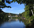
 Renatured Eisbach in Eisenberg |
||
The Eisbach , also known as the Eis in the region and the Altbach on the lower course , is a 38 km long stream in the northeastern Palatinate and in the southeast of Rheinhessen (both in Rhineland-Palatinate ). It rises near Ramsen in the northern Palatinate Forest and flows east to the Rhine , into which it flows as an orographically left tributary near Worms . Neighboring waters are the Eckbach and the Pfrimm , which flow south and north of the Eisbach to the Rhine.
Surname
The ice was first mentioned in writing in a document from the Lorsch Codex from 766, where it is called Isina . The name ice is not derived from the name research from the same word for frozen water , but either associated with the iron ore that was formerly mined in the region, or with the Germanic root īs ' move violently, hurry, flow quickly 'returned. The interpretation as "Eisenbach" comes from Ernst Christmann and is supported by the former name Isenberg of the main town Eisenberg . However, this interpretation is doubted or decidedly rejected by other researchers because it is based on a false rendering of the word "Isena" in the document Codex Laureshamensis , No. 820, "Isenade". Hans Ramge and Henning Kaufmann consider the origin of the name from the root īs to be possible or given. That the original ice now called ice stream carries, going to the Kingdom of Bavaria back to the left bank of the Palatinate from 1816 belonged. When the Bavarian officials mapped the Palatinate , they wanted to make it clear that the ice was a stream. Nevertheless, the old name has survived in the region to this day, e.g. B. in the name "Mühlheim an der Eis" for the district of the municipality of Obrigheim .
geography
course
.jpg)

The strongest of seven source brooks of the Eisbach rises on the northern slope of the Hohen Bühl ( 443 m above sea level ) in the northern Palatinate Forest southwest of the municipality of Ramsen at an altitude of about 290 m . After 1.5 km the Hollerbach flows into it from the left , which is a little longer at 2 km, but has less water. The 6 hectare Eiswoog reservoir begins at the confluence . Below this, the Eisbach at the hamlet of Kleehof takes on the 3.5 kilometer long Bockbach from the right . Here the initially northerly direction of flow changes to the northeast, which is now maintained up to the mouth. Then the Eisbach passes Ramsen and the small town of Eisenberg . At the lower end of Ebertsheim the 5 km long Seltenbach flows from the right and a few meters down from the left the strongest tributary, the 10 km long Rodenbach . After passing through the hamlet of Quirnheim-Tal and the municipality of Mertesheim , the Eisbach breaks through the western edge of the Upper Rhine Valley near the Grünstadt district of Asselheim and reaches the Upper Rhine Plain . Between Mertesheim and Asselheim there are rock formations made of brown sandstone on both sides of the valley , the so-called Kapuzinerstein , which was mined until the 20th century.
When crossing the western part of the plain, the Eisbach first flows through the districts of Albsheim , Mühlheim , Colgenstein , then the main town of Obrigheim and finally the hamlet of Neuoffstein . There it collects the water from the Südzucker plant that is produced during sugar beet processing , around 350 m³ per working day. After crossing the border with Rheinhessen, Offstein follows . Then the Eisbach passes the southwest and southern districts of the Nibelung city of Worms , namely Heppenheim , Wiesoppenheim , Horchheim and Weinsheim .
At the outlet in Weinsheim , the Wormser Stadtbach branches off from the Eisbach. This artificially created tributary, which has been completely canalized in pipes since the 1930s, crosses under the L 395 and then runs north past the Renolit factory , on through the site of the former Heyl'schen leather factory on Kirschgartenweg and Speyerer Schlag and along Eisbachstrasse in downtown Worms. Until the 19th century, the Stadtbach flowed largely openly through the city: it was led through the city wall next to the Leonhardspforte, then it flowed through the Gerbergasse, behind the Neumarkt and the Münze (today: Worms City Library ), under the Trinity Church , along Färbergasse and Zeughausgasse and south past the St. Paulusstift , then past the Bettelvogtturm through the city wall and from there directly in front of the wall to the north, without flowing into the Woog, which is directly next to it. Instead, the Stadt-Eisbach continued to flow in a northerly direction to the Bachspitze (where the Nibelungen School is today) and merged with the Giessen, which flowed into the Rhine at the Neuturm. The city stream has been running underground since the municipal sewer system was built in 1885-1893. The Woog was backfilled in 1842/43 and the Gießen was filled in in the course of the port construction from 1890–1893.
The main course of the Eisbach is called "Altbach" from Weinsheim . At the level of Landesstraße 523 (Worms - Bobenheim-Roxheim ) branches off from the Altbach to the left, the new Mariamünsterbach , which was created in the 1880s to relocate the old Maria-Münster-Bach. The old Maria-Münster-Bach was a tributary of the Stadtbach, which branched off in the Worms suburb at the Michaelskirche and moved to the Maria-Münster-Kloster, there ran through a water gate of the city wall and flowed further north to the Woog in front of the wall into which it flowed.
After the Mariamünsterbach junction, the Altbach flows through the Bürgerweide district south of the city center of Worms , before it flows into the Upper Rhine at the southern tip of the raft harbor at 89 m above sea level . Until the end of the 19th century, the Altbach flowed into the Gießen south of Worms.
Catchment area
The 130.18 km² catchment area of the Eisbach is drained via the Rhine to the North Sea.
It borders
- in the south to that of the Rhine tributary Eckbach
- in the southwest to that of the Hochspeyerbach , a tributary of the Speyerbach which flows into the Rhine
- in the west to that of the near tributary Alsenz
- and in the north to that of the Pfrimm , which also flows into the Rhine.
The highest point is the Hohe Bühl at 443.6 m above sea level. NHN in the southwest of the catchment area.
Tributaries
The following tributaries of the Eisbach are recorded with the river code number:
| Surname |
page |
Length [km] |
EZG [km²] |
Mouth on km |
Mouth |
GKZ |
|---|---|---|---|---|---|---|
| Hollerbach | Left | 1.99 | 2.97 | 1.36 | 23918-12 | |
| Habersbach | Left | 0.95 | 1.14 | 2.57 | 23918-132 | |
| Bockbach | right | 3.36 | 5.09 | 3.52 | above Ramsens | 23918-14 |
| Abttalbach | Left | 1.64 | 2.39 | 3.63 | 23918-16 | |
| Erbsbach (Bach am Lehrberg) | Left | 0.79 | 0.83 | 4.24 | 23918-18 | |
| Ellenbach | Left | 2.61 | 5.46 | 5.04 | Ramsen | 23918-2 |
| Rehbach | right | 1.32 | 1.23 | 6.00 | Ramsen | 23918-312 |
| Diebskellerbach | right | 2.55 | 1.72 | 6.92 | immediately below Ramsens | 23918-32 |
| Mill moat | Left | 0.39 | 0.10 | 12.68 | Eisenberg (-East) | 23918-392 |
| Seltenbach | right | 5.41 | 15.83 | 14.48 | immediately below Ebertsheims | 23918-4 |
| Rodenbach | Left | 8.84 | 42.84 | 14.55 | immediately below Ebertsheims | 23918-6 |
| Quirnheimer Bach | Left | 2.34 | 2.37 | 14.81 | immediately below Ebertsheims | 23918-72 |
| Paper trench | Left | 0.42 | 0.14 | 16.17 | Mertesheim | 23918-7912 |
| Kützelsborn | Left | 0.86 | 1.37 | 18.70 | Asselheim | 23918-792 |
| Krausmühlgraben | Left | 0.92 | 0.40 | 19.72 | below Asselheims | 23918-7992 |
| Reisbach | Left | 2.51 | 12.04 | 25.51 | Offstein | 23918-8 |
| Ice rift | right | 0.29 | 0.15 | 30.08 | Wiesoppenheim | 23918-932 |
geology
The oldest traces of the ice are deposits of fine red sand that were found near Monsheim . It is a weathered red sandstone from the Haardt , which was probably carried away in the Mindel I Glacial by a slowly flowing body of water, probably the earliest forerunner of the ice, and sedimented as a river terrace . The Eisbach Terraces have not yet been comprehensively investigated geologically. The relative sequence of the terraces has largely been clarified, but their chronological order is only partially certain.
| The Pleistocene terraces of the Eisbach to Garst | |||
|---|---|---|---|
| Terrace step | Level above ice bottom | Temporal allocation | Occurrence of the terrace step |
| Lower terrace | approx. 4–6 m | Young diluvium | Only begins east of Heppenheim , east of Horchheim as a wide cone of rubble up to the city of Worms |
| Younger Talweg terrace | approx. 10 m | Young diluvium | In Albsheim , Colgenstein-Heidenheim , Obrigheim , between Heppenheim and Horchheim |
| Older valley path terrace | approx. 20 m | Middle diluvium | In Mühlheim , Albsheim and Colgenstein-Heidenheim at the level between Heppenheim and Großniedesheim |
| Younger high terrace | approx. 35-40 m | Old diluvium | At Kerzenheim and Ebertsheim |
| Older high terrace | approx. 50-60 m | Old diluvium | Lowest parts of the gravel terraces at Stauf , Hertlingshausen , Hettenleidelheim , Wattenheim and Tiefenthal , as well as at Eisenberg |
| Younger main terrace | approx. 70 - 120 m | Old diluvium , near Monsheim : Mindel I-Glacial | Upper parts of the gravel terraces at Stauf , Hertlingshausen , Hettenleidelheim , Wattenheim and Tiefenthal . Also at different heights near Monsheim , Abenheim and Osthofen |
The Eisbach forerunner of the main terrace era still flowed in a north-easterly direction. The high terraces are already deposits at the edge of the valley, but only the valley path terraces are closely related to the current course of the ice. In the time of the older valley path terrace, the stream flowed from Colgenstein-Heidesheim south of its current bed directly to the east. Since the younger terrace of the valley path, the ice has roughly taken its current course. At the beginning of the Holocene , the flow rates of the Eisbach decreased considerably.
environment
River type
On the basis of the EU Water Framework Directive , the rivers in Germany were assigned to biocenotic types of rivers . Up to the confluence of Seltenbach and Rodenbach near Ebertsheim, the upper reaches of the Eisbach is a low-mountain range, rich in fine material, silicate (flowing water type 5.1). Below Ebertsheim, the Eisbach is a carbonate low mountain range, rich in fine to coarse material (flowing water type 9.1).
Water quality
The water quality of the Eisbach has been documented in biological water quality maps of the LAWA since 1990 . In 1990 the upper reaches of the Eisbach up to Ramsen was rated with quality class I-II (low pollution), from Ramsen to Asselheim the brook had quality class II-III (critically polluted) and from Asselheim to the mouth only quality class III (heavily polluted), whereby the wastewater from the sugar factory in Neuoffstein was particularly harmful. Up until 1995 there was a further deterioration in the Obrigheim-Offstein area to grade III-IV (very heavily soiled). The heavy pollution in the Eisenberg area through the introduction of commercial and industrial wastewater ended after 1995. In the particularly polluted area of Obrigheim-Offstein, a significant increase in water quality to grade II-III was achieved in the period 1995-2000 through the renovation of the Obrigheim wastewater treatment plant and improved ammonium elimination in the waste water systems of the Offstein sugar factory.
history
-_Richtung_Ost_14.9.2014.jpg)
The middle Eisbach valley was visited by ice age hunters and collectors as early as the Paleolithic . This is proven by stone tools from the Middle Paleolithic , which were discovered in Asselheim . Further finds from Asselheim date from the younger Paleolithic and Mesolithic . But only since the population explosion of the Neolithic Age is the permanent presence of people in the Eisbachtal expected. Neolithic settlements existed on Worms Adlerberg, in Weinsheim , Horchheim , Wiesoppenheim , Albsheim and Asselheim. The Worms Adlerberg is a small elevation raised by the Eisbach, with which the flood-safe mountain ranges reach directly to the banks of the Rhine. The same favorable location is offered in Worms by the Domberg and the Rheingewann, a cone of rubble at the Pfrimm estuary. These bridgeheads provided a privileged way to cross the river. The valleys of Pfrimm and Eis form natural corridors through the mountains and were therefore important east-west connections from the Rhine through the Kaiserslautern Depression to Gaul in prehistoric times. Worms owes its origins to this convenient location. "Of all the streams that flow into the Rhine to the south and north of Worms, only the Pfrimm and the Eis are of greater importance, as they formed the only high bank of the Rhine lowlands that was friendly to settlement." Although long-distance trade enjoyed a significant boom in the Bronze Age , there is there are hardly any Bronze Age finds from the upper ice valley. The upper ice valley was also inhabited during the Iron Age. At the latest in Roman times was the iron production in the area of Ramsen and the iron processing in Eisenberg started. A vicus with the character of a small-town industrial settlement was created in Eisenberg . The important long-distance route through the Eisbach valley was paved in Roman times, but was probably only a second-order Roman road . There was a beneficiary station in Eisenberg , which underlines the importance of the street. The path along the Pfrimm was at all times more important than the one through the ice valley. In Roman times, numerous Roman manors were built in the valleys of Eis and Pfrimm , which were lined up in relatively close succession. In the second half of the 5th century, Roman rule ended. The Franconian settlement of the ice valley began at the end of the 5th century. Almost all of today's Eisbach locations go back to Franconian settlements that were founded between the end of the 5th century and the 8th century. The road from Metz via Kaiserslautern through the Eistal to Worms played a central role in the settlement . This road won the Merovingian even more important because they Metz, the capital of the Eastern Empire part Austrien , combined with the Upper Rhine region. In the Saxon Wars of Charlemagne, the destination of Worms served as a gathering place for the armed forces, because there were sufficient storage and supply facilities for huge armies near the Palatinate.


The water power of the Eisbach is already in the Middle Ages used to mills to power, the paper mill in Quirnheim Valley, Kraus mill and the Schiffer mill in Albsheim or Stegmühle in Marloffstein. The first mention of a mill on the Eisbach comes from the year 766. But water mills were already known in Roman times and were also used in the Germanic provinces. There were numerous mills on the Eisbach. Before the city was destroyed in 1689, the brook drove eleven water mills in Worms alone and a further nineteen mills an hour's walk from Worms upstream. The Eisbach was well suited for the operation of water mills due to its fairly even flow of water. In contrast to the neighboring Pfrimm to the north, the ice also had sufficient water in longer dry periods .
In the 13th century, a king and his army camped twice on the Eisbach meadows near Heppenheim. King Konrad IV set up camp here for six days in August 1250 after the fight against William of Holland . About fifty years later, in the battle for the throne between King Adolf von Nassau and Duke Albrecht of Austria , the decision was made in the Battle of Göllheim . Immediately before the battle, King Adolf camped with his knight army at Heppenheim and Wiesoppenheim for several days until July 1, 1298 . There he found sufficient pastureland in the meadows on the Eisbach for his armed force, which is estimated to be around 5,000 men - mainly horsemen. The Wimpfener Chronik explicitly mentions the lush meadows near Heppenheim. After King Adolf died on July 2, 1298 in the Battle of Göllheim, the victor Albrecht of Austria refused to allow him to be buried in the Speyer Cathedral . That is why Adolf's body was first buried in the Cistercian convent Rosenthal , which was to the left of the Eisbach at its tributary Rodenbach . The coffin was only transferred to Speyer in 1309 . In Dom Adolf was buried next to his former rival Albrecht, 1308 by the own nephew had been killed.
The Stadt-Eisbach was of great importance for the city of Worms, not so much because of the drinking water - there were many wells in the city for this - but because of the process water that was needed by the mills, tanneries and dye works in the city. It has not yet been clarified whether the Stadtbach dates back to Roman times or was only derived from the original Eisbach run in the Middle Ages. In the 19th century, the city brook was either attributed to Charlemagne or the Worms Church. The Stadtbach was first mentioned in 1016, when Bishop Burchard gave away three mills near St.Paulus. Directly on the Eisbach, on the Roman city wall on the Rhine side, was the castle of the Salier dukes of Worms, which was demolished in 1002, around the St. Paulus monastery in the same place. The castle, "one of the oldest in the Rhine-Hessian-Palatinate area", is said to have been very strongly fortified. Hence the assumption that it was a moated castle. However, there cannot have been a moat on the east side of the castle. On the area of the castle there was previously a late Roman fortification from the 4th century, probably a fort, possibly to protect the Roman port that may be there in front of the wall. The sovereign rights over the city stream lay with the bishop in the high Middle Ages. At the end of the 12th century, a third of the Stadtbach was owned by the St Paul and St Martin monasteries and by some of the citizens of Worms, who sold their third to the Nonnenmünster monastery (i.e. Maria-Münster) sometime between 1198 and 1217. In the 14th century, the municipality tried to obtain sole rights to the Eisbach and in 1315 obtained a privilege from King Ludwig of Bavaria , which made draining the stream flowing into the city a heavy penalty. In 1381 the city received another privilege from King Wenceslas , which gave the city the right to freely dispose of the streams that flowed through the city and its suburbs. If the city saw itself impaired in its use of the Eisbach water, one even proceeded with violence against upstream residents on the Eisbach. In 1443 the Worms destroyed z. B. the moat in Heppenheim . The excavation of the city stream was an effective means of damaging the city for adversaries. In the dispute between Elector Philipp and Worms in 1483, the Eisbach was dug up, and Franz von Sickingen had the Stadtbach diverted during his siege of Worms in 1516. The people of Horchheim have also dug up the Eisbach several times in disputes.
Of the villages on the Eisbach, Heppenheim in particular operated extensive hydraulic engineering. In the parish of 1602 it is said that Heppenheim is allowed to dam the Eisbach 24 hours between St. Georg (April 23) and St. Bartholomew (August 24) and lead it to the village commons. The Heppenheim meadows and orchards were irrigated in this way until after the Second World War . The village, one of the largest in the Eisbachtal, was protected in the west, north and east by a ditch that was fed by the Eisbach flowing past Heppenheim in the south. A ditch ran in the middle of the main road through which the village was supplied with fresh water. In 1840 the channel was divided up and relocated to the side of the street. The watercourses on the main road (today: Pfälzer Waldstrasse and Wormser Landstrasse) were only removed in 1979 when the sewer system was introduced. There were also two mill ditches for the mills in Heppenheim. The Eisbach bifurcated into two arms at Heppenheim, the main course and the "small stream" flowing south of it. Shortly after the village, both streams reunited. A little below Heppenheim, the Eisbach divided again into a southern Eisbach main arm, which ran over Weidenmühle and pasture to Wiesoppenheim and the “Weidbach” running north. With the Eisbach regulation in the 1930s, the Eisbach near Wiesoppenheim was moved out of the village to the north into the bed of the Weidbach.
There were numerous fish and crabs in the Eisbach until the end of the 19th century. The wastewater from industrial companies such as the sugar factory in Offstein decimated stocks from the 1880s until they were finally completely wiped out. Other polluters at that time were the pottery factory in Offstein and the Pfeiffer & Diller coffee essence factory in Horchheim .
The Eisbachauen in the districts of Heppenheim , Wiesoppenheim , Horchheim and Weinsheim were declared a landscape protection area in 1990.
At the end of 2011, the renaturation of the stream between Ebertsheim and Offstein began. The aim is to make the watercourse passable again for fish and other aquatic organisms and thus to implement the EU's Water Framework Directive . Most of the 30 weirs and barrages , most of which can be found in this 12-kilometer stretch of stream, will be dismantled. Meanders are restored where possible ; Where the straightening cannot be reversed, concrete cubes with an edge length of around 50 cm that are placed in the streambed promote the deposition of debris so that the flow speed of the water decreases.
Sights and buildings
Ice valley
- Eiswoog
The Eisbach is dammed to the Eiswoog southwest of the municipality of Ramsen . There is a hotel-restaurant on the dam wall, below are managed fish ponds . There is a three-kilometer hiking trail around the lake. Trout , perch , pike and char can be found in the Eiswoog itself . Since the water is privately owned, fishing is prohibited. The strictly protected kingfisher nests at the lake ; the wheatear , which is very rare in Germany and placed on the Red List of Endangered Species in 2008 , was registered as a puller .
- Railway bridges
Technical sights of the ice valley are the bridge structures of the regional ice valley railway :
- The Eistal Viaduct , completed in 1932 and in operation until 1988, is 35 meters high and, with a length of 250 meters, is the longest railway bridge in the Palatinate.
- The Bockbachtalbrücke over the Bockbach was built for 375,000 RM and is 28.50 meters high and 170 meters long.
- The Dreibrunnentalbrücke , built for 245,000 RM, is 23 meters high and was constructed with a single arch without intermediate piers.
- Stump Forest Railway
The Stumpfwaldbahn , a museum-like narrow-gauge railway (600 mm) with open carriages, operates at certain times as a tourist attraction between Ramsen and the Eiswoog. Participation in the night torchlight rides is particularly popular .
Panorama at the Eiswoog

Stump Forest Railway
The "incorruptible hand"

Erdkaut landscape protection area
.jpg)


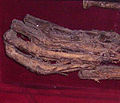
- The "incorruptible hand"
In the Protestant church of Eisenberg, the so-called "incorruptible hand" is shown in a showcase , about which a legend about perjury is told.
- Chewing earth
The Erlebnislandschaft Erdekaut between Eisenberg and Hettenleidelheim is a landscape protection area based on abandoned clay pits . A mining museum is operated in the centrally located historical building of the only surviving Riegelstein mine .
- action Day
Every year at the beginning of October, usually on the Day of German Unity , the “Car-Free Ice Valley ” day of action brings numerous visitors to the region. The state road 395, which leads from Grünstadt-Asselheim through the Eistal to Enkenbach , will be closed to all motorized traffic for one Sunday and is only available for pedestrians, usually hikers, as well as cyclists and inline skaters .
Worms

Worms Cathedral of St. Peter

Jewish cemetery Heiliger Sand

Luther monument, historical photo from 1902

Nibelungen Bridge


The former imperial and bishop's city of Worms at the mouth of the Eisbach is, as a Celtic Borbetomagus, possibly the oldest urban settlement in Germany. The city impresses with its medieval past. Worth seeing are z. For example, the Romanesque Cathedral of St. Peter , built in the 12th century , the city wall , the synagogue , the 11th century Holy Sand as probably the oldest Jewish cemetery in Europe, the town hall tower and the Nibelungen Bridge . The most significant historical event was Martin Luther's appearance at the Reichstag in 1521 .
Culture
A literary portrait of the Eisbach comes from the Palatinate writer Willi Gutting. Following the course of the brook, it depicts the landscapes of the ice valley and tells of history and legends. Guttings résumé der Eis concludes with the powerful words: "The ice, beset by the growing Worms and given the indestructible silhouette of the cathedral, reaches the river south of the Rhine bridge and sinks into its depths like the treasure of the Nibelungs once did".
literature
- Willi Gutting: The ice cream . In: Willi Gutting (ed.): Curricula vitae of Palatinate brooks . 2nd Edition. Arbogast, Otterbach and Kaiserslautern 1982, p. 125-133 .
- Georg Spieß: The Eiswoog through the ages . In: North Palatinate History Association (Hrsg.): North Palatinate History Sheets . Volume 82. Rockenhausen 2002, p. 49-53 .
Web links
- Bach sponsorship for the Eisbach . BUND, district group Worms
- Eisbach - Wiesoppenheim gauge . State Office for the Environment, Water Management and Trade Inspectorate Rhineland-Palatinate
Individual evidence
- ↑ Map services of the Federal Agency for Nature Conservation ( information )
- ↑ a b Topographic map, 1: 25,000.
- ↑ a b c d GeoExplorer of the Rhineland-Palatinate Water Management Authority ( information )
- ↑ a b Lorscher Codex No. 900. Retrieved on July 11, 2012 .
- ↑ Ernst Christmann: The settlement names of the Palatinate . 2nd Edition. tape 1 . Speyer 1968, p. 133 .
- ^ Christmann used the erroneous edition of the document Codex Laureshamensis, No. 820, by Heinrich Boos: Urkundenbuch der Stadt Worms , Volume 1, Berlin 1886, p. 4, No. 7. The edition by Karl Glöckner: Codex Laureshamensis , Volume 2 , Part 1, Darmstadt 1933, p. 244 literature.at brings the correct spelling. Cf. Hans Ramge: The settlement and field names of the city and district of Worms , Giessen 1979 (p. 312f), who considers Christmann's interpretation to be “not incontestable” (p. 313), and Henning Kaufmann: Der Eisbach (die Eis ) and the settlement name Eisenberg , in: Mitteilungen des Historisches Verein der Pfalz, Volume 73, 1976, pp. 175–177, which rejects it as untenable.
- ↑ Ramge, p. 313.
- ↑ Kaufmann, p. 175f.
- ^ Fritz Reuter: Peter and Johann Hamman. Hand drawings by Worms from the time before and after the city's destruction in 1689 in the "War of the Palatinate Succession" . Worms 1989. , pp. 42, 54-56, 70-74, 76-77, 84-89, 98-99.
- ↑ Gerold Bönnen (ed.): History of the city of Worms . Stuttgart 2005. , pp. 97, 200 and map 20 in the back cover with legend on p. 1025.
- ↑ Heinrich Boos : History of the Rhenish urban culture from its beginnings to the present with particular consideration of the city of Worms . tape 3 . Berlin 1899. , pp. 77-79.
- ↑ Michael Mahla: Worms around 1680 seen from the air. Retrieved on August 14, 2012 (based on drawings by Peter Hamman and Johann Friedrich Hamman).
- ^ Hermann Salomon: The municipal sewage disposal in Germany . tape 1 . Jena 1906, p. 433-434 .
- ↑ City map of Worms. Retrieved October 8, 2019 (official city map 2013 and historical city maps of Worms 1689, 1860, 1878, 1897, approx. 1904 and 1923).
- ^ Fritz Reuter: Karl Hofmann and "the new Worms" . Darmstadt and Marburg 1993, p. 183 .
- ↑ Reuter, Peter and Johann Hamman pp. 55, 58–59, 72–73, 86–89.
- ↑ Boos: History of the Rhenish Urban Culture. Volume 3, p. 78.
- ↑ With km the Eisbach kilometers downstream from the source meant.
- ↑ a b c Wilhelm Weiler: Pliocene and Diluvium in southern Rheinhessen. Part II. The Diluvium . In: Notes from the Hessian State Office for Soil Research . Born 81.Wiesbaden 1953, p. 206-235 . therein: pp. 209f and 234.
- ↑ Hans-Jürgen Scharpff: Explanations of the Geological Map of Hesse, 1: 25,000, sheet no. 6316 Worms . Wiesbaden 1977, p. 21st f .
- ↑ Ernst Garst: The Diluvium in southern Rheinhessen and in the Rheinpfalz . In: Report of the Upper Hessian Society for Nature and Medicine. Natural science Dept. NF 17. Giessen 1936, p. 147-195 . therein pp. 150-159, 163-165, 170-180. Attached is a map of the terraces of Pfrimm, Eis, Eckbach and Isenach.
- ↑ For the Pfrimm, the younger Talweg terraces of the Würm Ice Age were assigned: Wilhelm Weiler: The diluvial terraces of the Pfrimm with an appendix about old diluvial mammals from the area of Worms . In: Notepaper of the Geography Association and the Hessian Geological State Institute . Episode 5 Volume 13. Darmstadt 1931, p. 124-145 . , therein: p. 144. Enclosed as plate 14 is a map of the Pfrimmterrassen east of Wachenheim and the Eisterrassen east of Heppenheim.
- ↑ Garst, p. 165.
- ↑ Scharpff, p. 80 f.
- ↑ Types of rivers. Federal / State Working Group on Water LAWA, accessed on September 2, 2016 .
- ↑ LAWA Länderarbeitsgemeinschaft Wasser (Ed.): Map of the biocenotically significant river types in Germany. As of December 2003 . ( wasserblick.net [PDF]).
- ↑ Water quality map of the Federal Republic of Germany, 1991 edition . ( lawa.de [accessed on September 2, 2016] as of 1990). with text volume of the Länderarbeitsgemeinschaft Wasser LAWA (Ed.): The water quality map of the Federal Republic of Germany 1990 . Berlin 1991, p. 22 ( lawa.de [PDF; accessed on September 2, 2016] On p. 22, quality class II is given for the lower course of the Eisbach - obviously because of a printing error. As the map shows, quality class III is meant).
- ↑ State Working Group on Water LAWA (ed.): Water quality atlas of the Federal Republic of Germany. Biological water quality map 1995 . Berlin 1996, p. 34 ( lawa.de [PDF; accessed on September 2, 2016]).
- ↑ State Working Group on Water LAWA (ed.): Water quality atlas of the Federal Republic of Germany. Biological water quality map 2000 . Hanover 2002, p. 38, ( lawa.de [PDF; accessed on September 2, 2016]).
- ↑ Gaëlle Rosendahl: Paleolithic and Middle Stone Age in southern Rheinhessen and in the northern Front Palatinate . In: Archeology between Donnersberg and Worms . Regensburg 2008, p. 33-42 . , therein: pp. 38 and 41 f.
- ↑ Georg M. Illert: The prehistoric settlement picture of the Worms Rhine crossing . Worms 1951, p. 31 ff., 62 ff., 82 f., 98-102 .
- ^ Lothar Sperber: The Palatinate in the prehistory . In: Karl-Heinz Rothenberger, Karl Scherer, Franz Staab, Jürgen Keddigkeit (eds.): Palatinate history . 2nd Edition. tape 1 . Kaiserslautern 2002, p. 1-27 . , therein: p. 4 ff.
- ↑ Birgit Heide, Andrea Zeeb-Lanz: The Neolithic . In: Archeology between Donnersberg and Worms . Regensburg 2008, p. 43-54 .
- ^ Hartmut readers: Regional history guide through Rheinhessen . Berlin, Stuttgart 1969, p. 69-71 .
- ^ Illert: Settlement picture . Pp. 25–31, pp. 61f, pp. 75–79, quotation p. 29.
- ↑ Sparrowhawk, p. 13.
- ^ Illert: Settlement picture . Pp. 101-111.
- ↑ Gertrud Lenz-Bernhard: The Iron Age in the northern Front Palatinate and in the North Palatinate Bergland . In: Archeology between Donnersberg and Worms . Regensburg 2008, p. 85-92 .
- ↑ Helmut Bernhard , Ulrich Himmelmann, Thomas Kreckel, Helmut Stickl: The Roman Vicus Eisenberg: A center of iron processing in the northern Palatinate . In: Archeology between Donnersberg and Worms . Regensburg 2008, p. 133-140 .
- ^ Helmut Bernhard: Eisenberg . In: Heinz Cüppers: The Romans in Rhineland-Palatinate. Stuttgart 1990, pp. 358-362.
- ^ Hermann Graf: 1200 years Eisenberg (Palatinate) . Eisenberg 1963, p. 53-67 .
- ↑ Dieter Berger: Old ways and roads between Moselle, Rhine and Fulda. An attempt . In: Rheinische Vierteljahrsblätter . tape 22 . Bonn 1957, p. 176-191 . , therein: pp. 178-182.
- ↑ H.Bernhard describes the road Worms – Eisenberg – Metz as just as important as the Rheinuferstraße, which is one of the most important Roman roads: Helmut Bernhard: The Roman History of the Palatinate . In: Karl-Heinz Rothenberger, Karl Scherer, Franz Staab, Jürgen Keddigkeit (eds.): Palatinate history . 2nd Edition. tape 1 . Kaiserslautern 2002, p. 43-77 . , therein: p. 52.
- ^ Bernhard: Eisenberg , p. 360.
- ↑ Illert: Siedlungsbild , pp. 28, 30 f and 88.
- ↑ Helmut Bernhard: The Roman Age in the northern Front Palatinate and in the North Palatinate Bergland . In: Archeology between Donnersberg and Worms . Regensburg 2008, p. 97-105 . , therein p. 100.
- ↑ Jörg Fesser: Early medieval settlements in the northern Front Palatinate with special consideration of the Merovingian excavations and the Carolingian written sources . Mannheim 2006, p. 324-327 .
- ↑ Ursula Koch: The hinterland of Worms in the early Middle Ages . In: Archeology between Donnersberg and Worms . Regensburg 2008, p. 107-116 .
- ^ Theo Uhrig: Palatinate and Diocese of Worms in Carolingian times . In: Middle Rhine contributions to the Falzes research . Mainz 1964, p. 46-70 . , therein pp. 49 ff., 55 and 58.
- ^ Franz Staab: The Palatinate in the Middle Ages . In: Karl-Heinz Rothenberger, Karl Scherer, Franz Staab, Jürgen Keddigkeit (eds.): Palatinate history . 2nd Edition. tape 1 . Kaiserslautern 2002, p. 97-173 . , therein p. 103.
- ↑ a b c Jürgen Link: Eisbach is becoming "permeable" . In: Grünstadter Wochenblatt . Grünstadt February 16, 2012.
- ↑ Friedrich Wilhelm Weber: The history of the mills and the miller's trade in the Palatinate . Otterbach b. Kaiserslautern 1978, p. 48-50 .
- ↑ Lists of water mills on the Eisbach are offered by Weber, Geschichte der Mühlen , pp. 271, 273 and Eberhard Ref: Directory of all mills in the Palatinate on the left bank of the Rhine. (No longer available online.) Archived from the original on October 17, 2013 ; Retrieved November 18, 2013 .
- ↑ Reuter: Peter and Johann Hamman , p. 42 and p. 76 f., 84 f.
- ↑ Auction of a mill in Horchheim near Worms, Province of Rheinhessen . In: Pfälzer Zeitung . No. 29 . Ludwigshafen February 4, 1857 (enclosure).
- ↑ JF Boehmer: Regesta Imperii V n.4528h. Retrieved August 16, 2012 . Also Regesta Imperii V n.4528i.
- ↑ Heinrich Boos: History of the Rhenish urban culture from its beginnings to the present with particular consideration of the city of Worms . tape 1 . Berlin 1897, p. 529 .
- ^ JF Boehmer: Regesta Imperii VI n.997. Retrieved July 1, 2012 . Also Regesta Imperii VI n.994, 998 and 1000.
- ^ FW Theodor Schliephake : History of Nassau , Volume 3, Wiesbaden 1869, p. 471 f.
- ↑ MGH SS 30.1 p.672 Cronica ecclesiae Wimpinensis c.24. Retrieved July 1, 2012 .
- ^ Bönnen, History of Worms , p. 97.
- ^ Georg Lange: History and description of the city of Worms . Worms 1837. , p. 9.
- ↑ Boos: History of the Rhenish Urban Culture , Volume 3, p. 77 f.
- ^ Heinrich Boos, document book of the city of Worms , Volume 1, Berlin 1886, p. 35, no. 44.
- ^ Mathilde Grünewald: New theses on the Worms city walls . In: Mannheim history sheets . New episode band 8 . Ubstadt-Weiher 2001, p. 11-44 . with 7 card inserts, therein pp. 17 f., 25, 27 and fig. 4, 5, 24 and 30.
- ^ Hansmartin Schwarzmaier: From Speyer to Rome. Stations and traces of life of the Salians . Sigmaringen 1992. , pp. 28-37.
- ^ Mathilde Grünewald: The Salians and their castle in Worms . In: Horst Wolfgang Böhme (Hrsg.): Castles of the Salierzeit . Part 2. Sigmaringen 1991, p. 113-123 .
- ^ Jürgen Keddigkeit, Dieter Barz: Worms II (Grafenburg) . In: Jürgen Keddigkeit, Ulrich Burkhart, Rolf Übel (eds.): Palatinate Castle Lexicon . tape 4.2 . Kaiserslautern 2007, p. 418-420 . , Quotation p. 418.
- ↑ Peter Classen: Comments on the Palatinate Research on the Middle Rhine . In: Peter Classen, Josef Fleckenstein (Ed.): Selected essays by Peter Classen . Sigmaringen 1983, p. 475-501 . , therein p. 494
- ^ Mathilde Grünewald, Klaus Vogt: St. Rupert and St. Paul in Worms. Excavations at the collegiate church St. Paulus in Worms [part] V. In: P.Josef kleine Bornhorst OP (Hrsg.): St. Paulus in Worms 1002-2002 . Mainz 2002, p. 1-30 . , therein p. 11, note 21.
- ↑ Grünewald, New Theses on the Worms City Walls , pp. 17–21 and 24 f.
- ^ Mathilde Grünewald, Klaus Vogt: Spätrömisches Worms. Excavations at the collegiate church of St. Paul in Worms (III.) . In: The Wormsgau . tape 20 . Worms 2001, p. 7-26 . therein p. 25.
- ↑ Boos, document book of the city of Worms , Volume 1, p. 83, No. 104.
- ^ Heinrich Boos, Document Book of the City of Worms , Volume 2, Berlin 1890, p. 59, No. 94.
- ^ Heinrich Boos, Document Book of the City of Worms , Volume 2, pp. 507f, No. 783.
- ↑ Boos, History of Rhenish Urban Culture , Volume 3, p. 78 f.
- ^ Bönnen, Geschichte der Stadt Worms , p. 189.
- ^ Wilhelm Arnold (Ed.): Worms Chronicle by Friedrich Zorn with the additions of Franz Berthold von Flersheim . Stuttgart 1857. , p. 241.
- ^ Hermann Schmitt: History of Horchheim, Weinsheim and Wies-Oppenheim . Worms 1910. , p. 31.
- ^ Raimund Schmitt: Heppenheim an der Wiese. A home book in text, pictures and documents . Grünstadt 1971. , p. 78 f. Stadtarchiv Worms 02 suburbs 050 Heppenheim II, Lfd. Number 1.
- ↑ Werner Kropp: Heppenheim an der Wiese 250 years ago . In: Joachim Schalk (Ed.): Festschrift for Fritz Reuter on the 60th anniversary of his birth. Worms 1990, p. 132-142 .
- ↑ Karlheinz Henkes u. a. (Ed.): 1200 years of Wiesoppenheim. 793-1993 . Worms 1993. , pp. 15-17.
- ↑ Ludwig Dosch: The fish water and the fish of the Grand Duchy of Hesse . Giessen 1899, p. 20 .
- ↑ City administration Worms: Ordinance on the determination of the landscape protection area "Eisbachauen". (PDF; 68 kB) (No longer available online.) October 7, 1990, archived from the original on June 8, 2015 ; Retrieved July 1, 2012 .
- ↑ Observations in autumn 2004, see article discussion Eisbach .
- ↑ Rheinland-Pfalz-Takt : With the Eistalbahn to the green paradise. Retrieved August 27, 2010 .
- ↑ Gutting, p. 133