
La Salle (Saône-et-Loire)
| La Salle | ||
|---|---|---|
.svg)
|
|
|
| region | Bourgogne-Franche-Comté | |
| Department | Saône-et-Loire | |
| Arrondissement | Mâcon | |
| Canton | Hurigny | |
| Community association | Mâconnais Beaujolais Agglomération | |
| Coordinates | 46 ° 24 ' N , 4 ° 52' E | |
| height | 168-252 m | |
| surface | 5.67 km 2 | |
| Residents | 545 (January 1, 2017) | |
| Population density | 96 inhabitants / km 2 | |
| Post Code | 71260 | |
| INSEE code | 71494 | |
| Website | http://www.lasalle71.fr/ | |

La Salle is a French municipality with 545 inhabitants (as of January 1 2017) in the department of Saone-et-Loire in the region of Bourgogne Franche-Comté . It belongs to the arrondissement of Mâcon and the canton of Hurigny (until 2015: canton of Lugny ).
geography
La Salle is located about eleven kilometers north of the city center of Mâcon in the Mâconnais in the Bourgogne wine region and on the Saône . La Salle is surrounded by the neighboring communities of Saint-Albain in the north, Boz in the east, Senozan in the south, Charbonnières in the southwest and Clessé in the west.
Population development
| year | 1962 | 1968 | 1975 | 1982 | 1990 | 1999 | 2006 | 2013 |
|---|---|---|---|---|---|---|---|---|
| Residents | 413 | 422 | 393 | 448 | 464 | 440 | 482 | 562 |
| Source: Cassini and INSEE | ||||||||
Attractions
- Notre-Dame church
- La Salle Castle
- Donjon

La Salle Castle
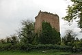
Donjon
_-_3.JPG)

Web links
Commons : La Salle - collection of images, videos and audio files