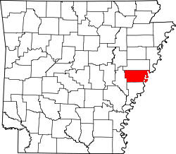
Lee County, Arkansas
![The Lee County Courthouse in Marianna, listed on the NRHP since 1995 [1]](https://upload.wikimedia.org/wikipedia/commons/thumb/9/99/Lee_County_Courthouse_001.jpg/298px-Lee_County_Courthouse_001.jpg) The Lee County Courthouse in Marianna, listed on the NRHP since 1995 |
|
| administration | |
|---|---|
| US state : | Arkansas |
| Administrative headquarters : | Marianna |
| Address of the administrative headquarters: |
County Courthouse 15 East Chestnut Street Marianna, AR 72360-2326 |
| Foundation : | April 17, 1873 |
| Made up from: |
Crittenden County Monroe County Phillips County St. Francis County |
| Area code : | 001 870 |
| Demographics | |
| Residents : | 10,424 (2010) |
| Population density : | 6.7 inhabitants / km 2 |
| geography | |
| Total area : | 1604 km² |
| Water surface : | 46 km² |
| map | |
The Lee County is a county in the US -amerikanischen State Arkansas . In 2010 , the county had 10,424 residents and a population density of 6.7 people per square kilometer. The county seat is Marianna .
geography
The county is located in the far east of Arkansas, bordered to the east by the Mississippi River , which forms the border with Mississippi . It has an area of 1604 square kilometers, of which 46 square kilometers are water. The county is traversed by the Saint Francis River in a north-south direction . The following neighboring counties border Lee County:
| St. Francis County | Crittenden County | |
| Monroe County |

|
Tunica County, Mississippi |
| Phillips County |
history
| Population development | |||
|---|---|---|---|
| Census | Residents | ± in% | |
| 1880 | 13,288 | - | |
| 1890 | 18,886 | 42.1% | |
| 1900 | 19,409 | 2.8% | |
| 1910 | 24,252 | 25% | |
| 1920 | 28,852 | 19% | |
| 1930 | 26,637 | -7.7% | |
| 1940 | 26,810 | 0.6% | |
| 1950 | 24,322 | -9.3% | |
| 1960 | 21.001 | -13.7% | |
| 1970 | 18,884 | -10.1% | |
| 1980 | 15,539 | -17.7% | |
| 1990 | 13,053 | -16% | |
| 2000 | 12,580 | -3.6% | |
| 2010 | 10,424 | -17.1% | |
| 1880–1890 1900–1990 2000 2010 | |||
Lee County was formed on April 17, 1873 from parts of Crittenden County, Monroe County, Phillips County and St. Francis County. It was named after Robert Edward Lee (1807-1870), a general in the US Army and in the Civil War (1861-1865), Commander in Chief of the Army of Northern Virginia in the Armed Forces of the Southern States ( Confederate States of America ).
Demographic data
As of the 2010 census , Lee County had 10,424 people in 3,516 households. The population density was 6.7 people per square kilometer. Statistically, 2.62 people lived in each of the 3516 households.
The racial the population was composed of 43.1 percent white, 54.4 percent African American, 0.6 percent Native American, 0.4 percent Asian and other ethnic groups; 1.4 percent were descended from two or more races. Hispanic or Latino of any race was 1.9 percent of the population.
20.3 percent of the population were under 18 years old, 63.9 percent were between 18 and 64 and 15.8 percent were 65 years or older. 44.5 percent of the population was female.
The median income for a household was 30,494 USD . The per capita income was $ 13,103. 28.8 percent of the population lived below the poverty line.
Localities in Lee County
structure
Lee County is divided into twelve townships :
| Township | Population (2010) |
FIPS |
|---|---|---|
| Big Creek Township | 80 | 05-90264 |
| Council Township | 27 | 05-90930 |
| Fleener Township | 309 | 05-91302 |
| Hampton Township | 690 | 05-91593 |
| Hardy Township | 11 | 05-91602 |
| Independence Township | 5266 | 05-91821 |
| Oak Forest Township | 350 | 05-92733 |
| Richland Township | 656 | 05-93138 |
| Spring Creek Township | 1882 | 05-93273 |
| St. Francis Township | 496 | 05-93459 |
| Texas Township | 383 | 05-93600 |
| Union Township | 274 | 05-93699 |
See also
Individual evidence
- ↑ Extract from the National Register of Historic Places - No. 95001090. Retrieved September 27, 2012
- ↑ GNIS-ID: 66866. Retrieved on February 22, 2011 (English).
- ↑ a b c U.S. Census Bureau, State & County QuickFacts - Lee County, AR ( Memento of the original from July 13, 2011 on WebCite ) Info: The archive link was automatically inserted and has not yet been checked. Please check the original and archive link according to the instructions and then remove this notice. Retrieved September 27, 2012
- ^ A b National Association of Counties.Retrieved September 27, 2012
- ^ US Census Bureau _ Census of Population and Housing.Retrieved February 17, 2011
- ^ Extract from Census.gov.Retrieved February 15, 2011
- ^ Extract from the Encyclopedia of Arkansas . Retrieved February 13, 2011
- ↑ Missouri Census Data Center - Arkansas ( page no longer available , search in web archives ) Info: The link was automatically marked as defective. Please check the link according to the instructions and then remove this notice. Retrieved September 27, 2012
Web links
Coordinates: 34 ° 47 ′ N , 90 ° 46 ′ W


