
Nakhon Sawan Province
| Nakhon Sawan | |
|---|---|
| นครสวรรค์ | |

|
|
| statistics | |
| Capital: | Nakhon Sawan |
| Telephone code: | 056 |
| Surface: |
9,597.7 km² 20. |
| Residents: |
1,072,868 (2009) 15. |
| Population density : | 112 E / km² 42. |
| ISO 3166-2 : | |
| Governor : | |
| map | |
  |
|

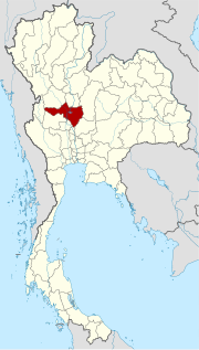
Nakhon Sawan ( Thai : นครสวรรค์ ) is a province ( Changwat ) in the southern part of the northern region of Thailand . The capital of Nakhon Sawan Province is also called Nakhon Sawan .
location

The province is considered the gateway to the north of the country and forms the southernmost part of northern Thailand. It is sometimes also counted in the central region.
The landscape is mostly flat. Here the rivers Mae Nam Ping and Mae Nam Nan flow together and form the Mae Nam Chao Phraya from the provincial capital Nakhon Sawan (also called Pak Nam Pho) , which flows into the Gulf of Thailand . In the east rise the mountains of Khao Pattawi.
In the center of the province, where the districts of Mueang Nakhon Sawan , Tha Tako and Chum Saeng meet, is the Bueng Boraphet swamp , with 132,737 Rai (212.38 km²) the largest freshwater wetland in Thailand. Part of the area is declared a bird sanctuary and is home to a great diversity of species.
The distance to the capital Bangkok is about 240 kilometers.
| Bordering provinces: | |
|---|---|
| north | Kamphaeng Phet |
| east | Phetchabun and Lop Buri |
| south | Sing Buri , Chai Nat and Uthai Thani |
| west | Tak |
Important cities
- Takhli
- Chumsaeng and
- Nong Bua
Important rivers
climate
The climate is tropical - monsoonal . The maximum temperature in 2009 was 36.7 ° C, the lowest temperature was measured at 16.8 ° C. In the same year, there was 1,415.4 mm of precipitation on 101 rainy days .
etymology
The name Nakhon Sawan goes back to the Sanskrit words nagara city and svarga ( स्वर्ग ) heaven, meaning city of heaven.
population
In the province, and especially in the provincial capital, there is a significant population of Chinese descent , whose ancestors immigrated since the end of the 19th century. In the eastern part of the province, immigration from the Petchabun province and from the Isan is also recorded. In addition, there are also descendants of the Lao Khrang laborers who were abducted by Siamese from Laos (the total number in Thailand is 53,000).
Economy and Importance
In 2009, the "Gross Provincial Product" (was GDP ) of the province of 81,842 million baht . The official minimum wage in the province is 232 baht per day (around € 4; as of April 1, 2012).
Data
The table below shows the share of the economic sectors in the gross provincial product in percent:
| Industry | 2006 | 2007 | 2008 | 2009 |
|---|---|---|---|---|
| Agriculture | 26.5 | 27.8 | 32.3 | 28.0 |
| Industry | 26.0 | 24.8 | 23.0 | 27.0 |
| Other | 47.5 | 47.4 | 44.7 | 45.0 |
Land use
The following land use is documented for the province:
- Forest area: 550,686 Rai (881.1 km²), 9.2% of the total area
- Agricultural area: 4,017,637 Rai (6,428.2 km²), 67.0% of the total area
- Unclassified area: 1,430,225 Rai (2,288.4 km²), 23.8% of the total area
There is an important inland port in the provincial capital. It emerged from an old rafting station that was in operation here until the logging of tropical precious woods was prohibited in 1989.
The timber trade is still an important source of revenue. Fishing is carried out in Bung Boraphet, a wetland area that is one of the main sources of freshwater fish in Thailand. The sua fish in particular is considered a delicacy and is sold across the country.
traffic
Rail transport
In the province there are several railway stations on the northern line of the SRT from Bangkok to Chiang Mai , which runs in a north-south direction:
| railway station | railway station | railway station |
|---|---|---|
| Chansens | Nong Pho | Bueng Boraphet |
| Chong Khae | Noen Makok | Khlong Pla Kot |
| Phon Thong | Khao Thong | Thap crit |
| Ban Takhli | Nakhon Sawan | Khlong Pla Kot |
| Hua Wai | Pak Nam Pho | Chumsaeng |
Bus transport
Nakhon Sawan has a long-distance bus terminal.
Air traffic
- Nakhon Sawan Airport (ICAO: VTPN) is currently not served by any scheduled airline
- Takhli Airport (ICAO: VTPI), Royal Thai Air Force military airfield
Educational institutions
Universities
- Chaophraya University , (private university, since 1999)
- Rajabhat Nakhon Sawan University
- Mahachulalongkornrajavidyalaya University : Nakhon Sawan Buddhist College
history
The area has been inhabited since the earliest times, as archaeological finds show. Especially in the area along the Mae Nam Chao Phraya and between Mueang Nakhon Sawan and Chumsaeng. The Tai peoples who seeped in in the 11th century (the ancestors of today's Thai) took possession of the area and grew wet rice here. Numerous smaller principalities ( Mueang ) emerged, which were finally taken over by the Khmer (Angkor) in the 12th century.
Only Sukhothai was able to push back their influence and finally it was Ayutthaya who incorporated the area into the Siamese Empire.
After King Mongkut (Rama IV) signed the Bowring Treaty with Great Britain in 1855 , the Golden Age of Nakhon Sawan began. It became the center of the rice and teak trade. The construction of the Northern Line of the Railway in 1922, the economic crisis before the revolution of 1932 and the construction of the Dechatiwong Bridge ( สะพาน เด ชาติ วงศ์ ) and the Phahonyothin Expressway reduced the importance of inland waterways and therefore the importance of Nakhon Sawan.
When King Chulalongkorn (Rama V) introduced the Monthon in 1895 as part of his Thesaphiban administrative reform, Nakhon Sawan became the capital of the "Monthon Nakhon Sawan".
Attractions

( See entry in Nakhon Sawan )
- Khao Woranat Banphot (Khao Kop) - Mountain in Amphoe Mueang with a wonderful view of the provincial capital and the Bueng Boraphet swamps. On the mountain is Wat Woranat Banphot, a Buddhist temple complex ( Wat ) . According to legend, the temple was founded in the 13th century by King Li Thai of Sukhothai . In the viharn there are footprints of Buddha from the Sukhothai period.
- Bueng Boraphet - wetland, which was made the largest freshwater lake in Thailand (140,000 Rai , 22.4 km²), in which 148 species of freshwater fish live. The area is also home to many rare birds.
- Wat Kriangkrai Klang in Tambon Kriangkrai (Amphoe Mueang) - temple complex at Maenam Nan, 22 km northeast of Nakhon Sawan, with many monkeys and a small crocodile farm.
- Wat Chansen Museum - in Amphoe Takhli; Museum for the folklore of the province with numerous finds, bronze and iron goods as well as everyday objects from earlier times.
- Khao Noh / Khao Kaeo - in the Tambon Ban Khaen (Amphoe Banphot Phisai); Limestone cliffs that are populated by monkeys and bats.
- Local festival:
- Kite Festival - the Kite Festival takes place in January / February for the Chinese New Year, with a large procession accompanied by a huge kite. Nakhon Sawan is also called the Dragon City .
-
National parks :
- National Park Mae Wong (Thai: อุทยานแห่งชาติ แม่ วงก์ ) - 55th National Park of Thailand, was opened in September 1987, size: 894 km², is located in the province of Nakhon Sawan as well as in the province of Kamphaeng Phet .
- Forest reserves:
- Khao Luang Forest Park (Thai: วนอุทยาน เขา หลวง )
- Tham Phet-Tham Thong Forest Park (Thai: วนอุทยาน ถ้ำ เพชร - ถ้ำ ทอง )
coat of arms
The coat of arms shows a Wimarn (a mythological castle in the sky, see also Wimanmek , teak "Palace in the Clouds", Bangkok), which refers to the name of the provincial capital: "City of Heaven".
The provincial tree and provincial flower is the purple loosestrife ( Lagerstroemia loudinii ).
The motto of Nakhon Sawan Province is:
- "The city where four rivers meet,
- The kite festival is celebrated by the Chinese Thai,
- The city of the great lake for recreation, Bung Boraphet,
- Everyone is invited to taste numerous tasty fish. "
Administrative units
Provincial Administration
The province of Nakhon Sawan is divided into 15 districts ( Amphoe ) . The districts are further subdivided into 130 parishes ( tambon ) and 1,328 villages ( muban ) .
|

Local administration
A provincial administrative organization ( บริหาร ส่วน จังหวัด , อบ จ for short , Ongkan Borihan suan Changwat ; English Provincial Administrative Organization , PAO) exists for the entire area of the province .
In the province there are not only one big city ( เทศบาล นคร - Thesaban Nakhon ) Nakhon Sawan ( เทศบาล นคร นครสวรรค์ ) but also two cities ( เทศบาล เมือง - Thesaban Mueang ):
- Takhli ( เทศบาล เมือง ตาคลี ) and
- Chum Saeng ( เทศบาล เมือง ชุมแสง ).
There are also 15 small towns ( เทศบาล ตำบล - Thesaban Tambon ).
literature
- Thailand in Figures, Vol.II: Region and Province . 16th edition 2012-2013, Alpha Research Co., Ltd., Nonthaburi, Thailand 2012, ISBN 978-616-7256-12-6
Web links
- Provincial Administration website (in Thai)
- Nakhon Sawan Province Information - Tourism Authority of Thailand TAT website
Individual evidence
- ↑ บึง บอระเพ็ด จ. นครสวรรค์ [Bueng Boraphet, Nakhon Sawan Province], HolidayThai.com
- ↑ Stefan Loose Travel Guide Thailand. 2014, p. 287.
- ↑ a b c Thailand in Figures (2012), p. 241
- ↑ "Industry" includes: Mining and quarrying; Manufacturing; Electricity, gas and water supply; Construction .
- ^ "Others" include: Wholesale and retail trade; Hotels and restaurants; Transport, storage and communication; Real estate; Education; Health and social work, ...
- ↑ Takhli military airfield
- ↑ Department of Provincial Administration : As of 2012 (in Thai)
North : Chiang Mai | Chiang Rai | Kamphaeng Phet | Lampang | Lamphun | Mae Hong Son | Nakhon Sawan | Nan | Phayao | Phetchabun | Phichit | Phitsanulok | Phrae | Sukhothai | Tak | Uthai Thani | Uttaradit
Northeast : Amnat Charoen | Bueng Kan | Buri Ram | Chaiyaphum | Kalasin | Khon Kaen | Loei | Maha Sarakham | Mukdahan | Nakhon Phanom | Nakhon Ratchasima | Nong Bua Lam Phu | Nong Khai | Roi Et | Sakon Nakhon | Si Sa Ket | Surin | Ubon Ratchathani | Udon Thani | Yasothon
Central : Ang Thong | Ayutthaya | Bangkok | Chachoengsao | Chai Nat | Chanthaburi | Chon Buri | Kanchanaburi | Lop Buri | Nakhon Nayok | Nakhon Pathom | Nonthaburi | Pathum Thani | Phetchaburi | Prachin Buri | Prachuap Khiri Khan | Ratchaburi | Rayong | Sa Kaeo | Samut Prakan | Samut Sakhon | Samut Songkhram | Saraburi | Sing Buri | Suphan Buri | Stepped
South : Chumphon | Krabi | Nakhon Si Thammarat | Narathiwat | Pattani | Phang-nga | Phatthalung | Phuket | Ranong | Satun | Songkhla | Surat Thani | Trang | Yala
Coordinates: 15 ° 41 ′ N , 100 ° 7 ′ E