
Tamsweg
|
market community Tamsweg
|
||
|---|---|---|
| coat of arms | Austria map | |
 |
|
|
| Basic data | ||
| Country: | Austria | |
| State : | Salzburg | |
| Political District : | Tamsweg | |
| License plate : | TA | |
| Surface: | 117.45 km² | |
| Coordinates : | 47 ° 8 ' N , 13 ° 49' E | |
| Height : | 1022 m above sea level A. | |
| Residents : | 5,741 (January 1, 2020) | |
| Postal code : | 5580 | |
| Area code : | 06474 | |
| Community code : | 5 05 10 | |
| NUTS region | AT321 | |
| UN / LOCODE | AT TAM | |
| Address of the municipal administration: |
Marktplatz 1 5580 Tamsweg |
|
| Website: | ||
| politics | ||
| Mayor : | Georg Gappmayer ( ÖVP ) | |
|
Municipal Council : (2019) (25 members) |
||
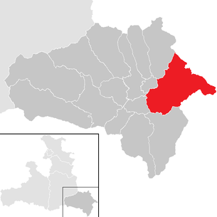
| Location of Tamsweg in the Tamsweg district | ||
  |
||
 View of Tamsweg from St. Leonhard |
||
| Source: Municipal data from Statistics Austria | ||

Tamsweg is a market town in the Austrian state of Salzburg with 5741 inhabitants (as of January 1, 2020).
Tamsweg is the seat of the Tamsweg district administration responsible for the entire Lungau and the Tamsweg district court . Tamsweg is, along with Reutte, one of the two municipalities of a district authority in Austria that have not been elevated to the status of a city .
geography
Tamsweg is located on the Preber mountain in the eastern Lungau Basin (also known as the Tamsweg Basin ) in a wide basin at the confluence of the Mur , Lungau Taurach and Leißnitzbach rivers. In the north, the Lower Tauern frame the basin. Tamsweg borders Styria in the east and is mainly developed from there.
Community structure
The municipal area comprises the following eight localities (population in brackets as of January 1, 2020):
- Haiden (249)
- Keusching (46)
- Lasaberg (172)
- Mörtelsdorf (959)
- Sauerfeld (429)
- Seetal (140)
- Tamsweg (3563)
- Wolting (183)
The community covers 117.45 km² and consists of the eight cadastral communities Haiden, Keusching, Lasaberg, Mörtelsdorf, Sauerfeld, Seetal, Tamsweg and Wölting.
Neighboring communities
Eight municipalities border Tamsweg, four of which are in the Murau district (MU).
| Sankt Andrä im Lungau | Lessach | Krakow (MU) |
| Mariapfarr |
.svg)
|
Ranten (MU) |
| Unterberg | Ramingstein |
Stadl-Predlitz (MU)
|
climate
| Tamsweg 1971-2000 | ||||||||||||||||||||||||||||||||||||||||||||||||
|---|---|---|---|---|---|---|---|---|---|---|---|---|---|---|---|---|---|---|---|---|---|---|---|---|---|---|---|---|---|---|---|---|---|---|---|---|---|---|---|---|---|---|---|---|---|---|---|---|
| Climate diagram | ||||||||||||||||||||||||||||||||||||||||||||||||
| ||||||||||||||||||||||||||||||||||||||||||||||||
|
Average monthly temperatures and precipitation for Tamsweg 1971–2000
|
||||||||||||||||||||||||||||||||||||||||||||||||||||||||||||||||||||||||||||||||||||||||||||||||||||||||||||||||||||||||
history
The Lungau was settled by Slavs from around 600 and by Bavarians from around 700 . The name is mentioned in a document around 1156 as Taemswich and could come from a Mr. Domes who settled here with his clan around the year 700. At that time, the Carinthian nobleman Eberhard von der Drau handed over an estate near Tamsweg to the Salzburg cathedral chapter .
In 1246 Archbishop Eberhard II bought the Lungau property of the Lords of Pettau and donated the church and half of the market to the cathedral chapter. Even then Tamsweg was likely to have been its own parish . A church is first mentioned in a document in 1231, at that time still as a subsidiary church of Mariapfarr .
From 1428 to 1433 the pilgrimage church of St. Leonhard was built on a hill south of the village. Tamsweg became a place of pilgrimage known far beyond the borders of Austria and experienced a significant economic boom.
A setback occurred in 1490 when Tamsweg in the course of the wars of Emperor Frederick III. against the Hungarian King Matthias Corvinus , whose troops had established themselves in the fortified St. Leonhard's Church, was pillaged and looted by imperial troops. The Reformation also brought a decline in pilgrimages, which only took off again with the settlement of Capuchins in the course of the Counter Reformation in 1644.
In 1571 the place became the residence of the barons of Kuenburg . The Archbishop of Salzburg, Georg von Kuenburg , gave the place a market coat of arms in 1587. The oldest verifiable weekly market privilege dates back to 1416; however, the market law should go back to the time of the Pettauer.
From around 1700 there was a brisk trade in salt and iron , which was an important source of income for the Tamsweg citizens for more than 200 years.
1797 Tamsweg was in the War of the First Coalition occupied by French troops and had a pillage of 4518 guilders afford. In addition, 222 oxen and large quantities of food and feed were requisitioned .
After the Peace of Luneville the former archbishopric of Salzburg came as Crown land and therefore Tamsweg in Austria . The 19th century brought a decline into insignificance for the region, which was accompanied by population decline, poverty and development deficits.
Only around the turn of the 20th century did the region experience a boom again, so the Murtalbahn was opened in 1894 , an electricity station and a water pipe were built in 1897 and the hospital opened in 1908.
In 1936 six surrounding rural communities were incorporated and the community area expanded to the size it is today.
population
Population development

Religions
The vast majority (88.2%) of the population belong to the Roman Catholic denomination. The second largest religious community is Islam , to which 3.4% profess. 1.3% of the population are evangelical . 6.0% of the population have no religious beliefs.
Bishop Johann Ebser von Chiemsee consecrated the new church on September 20, 1433. In addition to Mariazell and St. Wolfgang , the particularly beautifully situated pilgrimage church of St. Leonhard ob Tamsweg was one of the most popular pilgrimage sites on today's Austrian territory in the late Middle Ages.
coat of arms
In the coat of arms of 1587 the coat of arms is described as follows:
“ Aine gold-colored or yellow shield, and under it are three pointed rocks, the one higher than the other, and in the gold-colored or yellow field ain Gämbß, with the front leuffe straight above them jump towards the right side, and step with the obstacles on the niderist rock (...). "
Blazon : “In the golden shield three pointed, naturally colored rocks rising from left to right next to each other. From the left crag a chamois jumps over the other two crags. "
politics

The community council has a total of 25 members.
- With the municipal council and mayoral elections in Salzburg in 2004, the municipal council had the following distribution: 15 ÖVP, 8 SPÖ, and 4 FPÖ.
- With the municipal council and mayoral elections in Salzburg in 2009 , the municipal council had the following distribution: 12 ÖVP, 7 SPÖ, 4 FPÖ, and 2 GRÜNE.
- With the municipal council and mayoral elections in Salzburg in 2014 , the municipal council had the following distribution: 16 ÖVP, 4 FPÖ, 3 SPÖ, and 2 GRÜNE.
- With the municipal council and mayoral elections in Salzburg 2019 , the municipal council has the following distribution: 15 ÖVP, 5 FPÖ, and 5 SPÖ.
- mayor
- 1949–1977 Johann Hagenauer (ÖVP)
- 1977–1987 Josef Ehrenreich (ÖVP)
- 1987–2003 Hans Rauscher (ÖVP)
- 2003–2012 Alois Lankmayer (ÖVP)
- since 2012 Georg Gappmayer (ÖVP)
Culture and sights
- Schlossberg castle ruins
- Klausegg castle ruins
- Kuenburg Castle
- Pilgrimage church of St. Leonhard ob Tamsweg
- Deanery Parish Church Tamsweg hl. James the Elder
- Seetal parish church
- The Verein Vereinigte zu Tamsweg , a burial brotherhood founded by craftsmen in 1738 in the regional area of Tamsweg, was included in the list of Austria (national cultural property) in 2010 as an intangible world heritage , as declared by UNESCO . They accompany funerals , take part in church processions and hold the United Octave (a festival week) every year between January 1st and the Saturday after Ash Wednesday.

Samson parade - station in front of the town hall
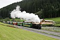
Special steam train of the Murtalbahn between Madling and Tamsweg


Economy and Infrastructure
Companies
The Coop Shopping Center is the largest retail company in Lungau with a sales area of 3600 m². The City Center Tamsweg opened its doors in December 2005 to complement the branch mix in the heart of the main town .
traffic
Tamsweg can be reached from the east through the Murtal via the Turracher Straße B 95 and the Murtalbahn and via Krakaudorf via the Murtal Straße B 96.
The B 95 continues west from Tamsweg to Mauterndorf , where it continues in Katschberg Strasse B 99 over the Radstädter Tauern Pass to Radstadt .
The B 96 leads through the Murtal to St. Michael im Lungau , where it also joins the B 99 over the Katschberg to Spittal an der Drau . In St. Michael im Lungau there is also a connection to the A 10 Tauern motorway .
Tamsweg also has a train station for the narrow-gauge Mur Valley Railway from Unzmarkt to Mauterndorf.
Public facilities
Tamsweg is the district capital and thus the seat of a number of offices and authorities, such as the district authority, the Chamber of Labor and the District Chamber of Farmers. In Tamsweg there is also a district court as well as three elementary schools , a new middle school , a federal high school , a business academy and a business school for information technology, as well as an agricultural school .
Charitable institutions
The market town of Tamsweg is the location of a regional center of Caritas Salzburg .
education
- Elementary schools in Tamsweg and Seetal
- New middle school
- Higher education schools:
- Federal high school
- Federal Trade Academy
- Federal commercial school for information technology
- Agricultural school
- State vocational school
- Polytechnic school
- Center for Inclusive and Special Education
Offices
- District Commission
- District Court
- Tax office
- District Police Command and Police Inspectorate
- Post office
- Labor market service
- Strucker barracks of the Austrian Armed Forces ( JgB 26 )
Health and care facilities
- Public hospital
- Retirement home
Personalities
- Franz Eßl (* 1957), farmer and politician
- Reinhold Esterbauer (* 1963), Roman Catholic theologian
- Rafael Fingerlos (* 1986), singer
- Lisa Grill (* 2000), ski racer
- Elisabeth Grübl (* 1961), artist
- Manfred Grübl (* 1965), artist
- Adolf Ritter von Guttenberg (1839–1917), professor of forestry
- Emil Ritter von Guttenberg (1841–1941), Lieutenant Marshal and Minister of Railways
- Valentin Hatheyer (1867–1957), Catholic priest and local researcher
- Dietbert Kowarik (* 1974), politician
- The Lederwasch family of painters was based in Tamsweg
- Sandro Lindschinger (* 1985), soccer player
- Gerwald Mandl (* 1940), Austrian university professor and economist
- Günther Matzinger (* 1987), sprinter and medium-distance runner
- Eva Moser (1982-2019), chess player
- Florian Pagitsch (* 1959), organist and music teacher
- Benedict Pettschacher (1634–1701), Benedictine, rector of the University of Salzburg
- Stefan Petzner (* 1981), politician (BZÖ), book author and PR consultant
- Philipp Pöllitzer (* 1940 in Mörtelsdorf), Catholic clergyman, emeritus Bishop of Keetmanshoop in Namibia
- Max Prodinger (* 1976), tenor
- Ramona Siebenhofer (* 1991), ski racer
- Leonhard Steinwender (1889–1961), priest and resistance fighter against National Socialism
- Ingrid Stöckl (* 1969), ski racer
- Franz Zaunschirm (* 1953), university professor, musician and composer
literature
- Klaus, Anton and Josefine Heitzmann: Tamsweg. The story of a market and its rural communities. Wolfgang Pfeifenberger Verlag, Tamsweg 2008, ISBN 978-3-901496-15-8 .
- Franz Martin: The monuments of the political district Tamsweg in Salzburg. Austrian Art Topography 22, Vienna 1929.
Web links
- 50510 - Tamsweg. Community data, Statistics Austria .
- Community website
Individual evidence
- ↑ Statistics Austria: Population on January 1st, 2020 by locality (area status on January 1st, 2020) , ( CSV )
- ↑ Valentin Hatheyer: Chronicle of the Tamsweg market . S. 81 .
- ↑ Klaus Heitzmann: Tamsweg, history of a market and its rural communities . Ed .: Klaus, Anton and Josefine Heitzmann. Tamsweg 2008, ISBN 978-3-901496-15-8 , pp. 22 .
- ↑ Josef Ehrenreich . In: Salzburger Nachrichten : Salzburgwiki .
- ↑ Hans Rauscher . In: Salzburger Nachrichten : Salzburgwiki .
- ↑ Alois Lankmayer . In: Salzburger Nachrichten : Salzburgwiki .
- ↑ Georg Gappmayer . In: Salzburger Nachrichten : Salzburgwiki .
- ↑ Vereinigte zu Tamsweg ( Memento of the original from March 4, 2016 in the Internet Archive ) Info: The archive link was inserted automatically and has not yet been checked. Please check the original and archive link according to the instructions and then remove this notice. . nationalagentur.unesco.at
- ↑ Tamsweg community, school and education. Retrieved July 21, 2019 .
- ^ Caritas Salzburg, Help and Offers, Tamsweg Regional Center. Retrieved July 21, 2019 .

Göriach | Lessach | Mariapfarr | Mauterndorf | Muhr | Ramingstein | St. Andrä | St. Margarethen | St. Michael | Tamsweg | Thomatal | Tweng | Unterberg | Weißpriach | Cedar house