Stockstadt am Main
| coat of arms | Germany map | |
|---|---|---|

|
Coordinates: 49 ° 59 ' N , 9 ° 4' E |
|
| Basic data | ||
| State : | Bavaria | |
| Administrative region : | Lower Franconia | |
| County : | Aschaffenburg | |
| Height : | 117 m above sea level NHN | |
| Area : | 18.88 km 2 | |
| Residents: | 8002 (Dec. 31, 2019) | |
| Population density : | 424 inhabitants per km 2 | |
| Postal code : | 63811 | |
| Area code : | 06027 | |
| License plate : | AB , ALZ | |
| Community key : | 09 6 71 155 | |
| LOCODE : | DE SYS | |
| Market structure: | 1 district | |
Market administration address : |
Hauptstrasse 19–21 63811 Stockstadt a. M. |
|
| Website : | ||
| Mayor : | Rafael Herbrik ( SPD ) | |
| Location of the Stockstadt a.Main market in the Aschaffenburg district | ||
Stockstadt am Main (officially: Stockstadt a.Main ) is a market in the Lower Franconian district of Aschaffenburg . It is best known for the Stockstadt Castle and the oldest proven Christmas tree in Germany.


geography
Geographical location
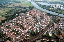
Stockstadt am Main is located west of the city of Aschaffenburg on the left side of the Main. The border with Hesse is to the west and northwest of Stockstadt. The topographically highest point of the municipality district is located at 144 m above sea level. NN (location) in the forest area between Stockstadt and Babenhausen , the lowest is at the Gersprenz estuary in the Main at 101.7 m above sea level. NN (location) .
Community structure
There is only the district and the district Stockstadt am Main. Stockstadt can be unofficially divided into several settlement areas, which were gradually developed.
Neighboring communities
| Community Mainhausen |
Municipalities of Kleinostheim and Mainaschaff |
|
| City of Babenhausen |

|
City of Aschaffenburg |
| Großostheim market |
Historic region
Together with the districts of Leider and Nilkheim of the city of Aschaffenburg, the district of Dorndiel of the city of Großumstadt, the city of Obernburg and the communities of Niedernberg, Großwallstadt and Mömlingen, the districts of Radheim and Mosbach of the community of Schaafheim and the market in Großostheim, the market town of Stockstadt formed the historic Bachgau region . At present, only the places Großostheim with the districts Ringheim, Pflaumheim and Wenigumstadt on the Bavarian side and the community Schaafheim with the districts Mosbach and Radheim in Hesse belong to the Bachgau. Stockstadt no longer belongs to the Bachgau.
Surname
etymology
The name Stockstadt consists of the Old High German words stoc , which means tree trunk and stat , for site. It probably goes back to a time in which the stumps after the slash left and Vermoderung were left. The name addition on the Main distinguishes the place from Stockstadt am Rhein .
Earlier spellings
Earlier spellings of the place from various historical maps and documents:
|
|
history
In 1820 “interesting Roman antiquities” were discovered in Stockstadt. With these discoveries and further excavations, the existence of a Roman fort for Stockstadt in the course of the Upper German-Raetian Limes could be documented for the time of Emperor Trajan at the latest . It existed until the Romans withdrew around AD 260. The Roman site Stockstadt is best known for the numerous stone monuments that were discovered in the vicinity of the fort. In the vicinity of the fort there were several brick kilns assigned to the military brickworks operated by the cohors III Aquitanorum stationed in Stockstadt . The former fort area south of the Rhein-Main-Bahn is today largely built over with a pulp mill.
Stockstadt am Main was mentioned in writing as early as the middle of the 9th century, if only on the basis of a few taxable citizens. These were designated as residing in Stocestat ; that's what the place was called at the time. The place itself was mentioned in writing for the first time in 1024. The village of Stoddenstat was given to the Fulda monastery by Emperor Heinrich II . This remained so until 1309, when Stockstadt was handed over to the Archdiocese of Mainz . In the Middle Ages, the surrounding forests belonged to the Dreieich Wildbann , which maintained one of its 30 Wildhuben in Stockstadt .
A historical source dates to the year 1527 and shows that the oldest Christmas tree in Germany comes from the Stockstadt Hübnerwald. In a file of the Mainz rulers from that time, "the weiennacht tree" in the Hübnerwald is mentioned in a document. Chancellery. 16th Century.
On July 1, 1862, the district office of Aschaffenburg was formed, on whose administrative area Stockstadt was located. In 1939, as everywhere in the German Reich, the designation district was introduced. Stockstadt was now one of the 33 communities in the old district of Aschaffenburg . On July 1, 1972, this merged with the Alzenau district in Lower Franconia to form the new Aschaffenburg district.
politics
Market council
The market town council of Stockstadt am Main has 21 members including the full-time mayor.
| CSU | SPD | FWG | total | |
|---|---|---|---|---|
| 2002 | 7th | 11 * | 3 | 21 seats |
| 2008 | 11 * | 7th | 3 | 21 seats |
| 2012 | 9 * | 7th | 5 | 21 seats |
| 2014 | 9 * | 8th | 4th | 21 seats |
| 2020 | 7th | 9 * | 5 | 21 seats |
* including mayor
mayor
Rafael Herbrik (SPD) has been the mayor since May 1, 2020; he was elected in the runoff election on March 29, 2020 with 61.0% of the valid votes. His predecessor was Peter Wolf (CDU), in office from May 2008 to April 2020.
coat of arms
The oval local seal from the 17th century showed the first letters of the name under the Kurmainzer wheel. On February 16, 1952, the coat of arms designed by Friedrich Merzbacher was approved.
Blazon : In blue over a lowered silver wave bar, a silver legionnaire's helmet with a red crest in side view.
Partner communities
-
 France : Stockstadt has three partner municipalities in France. These are the neighboring municipalities of Saint-André-sur-Orne , Saint-Martin-de-Fontenay and May-sur-Orne .
Attractions
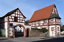
- The customs house on the main road served as a customs post for the Archbishop of Mainz and Elector Albrecht of Brandenburg for a long time . It was built from 1514 to 1545 (coordinates: 49 ° 58 '52.54 " N , 9 ° 3' 42.26" O )
- The Leonharduskirche is also located in the old part of Stockstadt and dates back to 1773. (Coordinates: 49 ° 58 ′ 50.2 ″ N , 9 ° 3 ′ 47.3 ″ E )
- The St. Anna Chapel, built in 1458, originally stood on the corner of Hauptstrasse and Alter Stadtweg. Its demolition took place in January 1925 on a municipal council resolution. In 2007 the chapel was rebuilt according to the historical model elsewhere, west across the B 469 towards Auhof, and consecrated on April 6, 2008.
Architectural monuments
Soil monuments
Infrastructure
traffic
The federal autobahn 3 , the federal road 26 , the federal road 469 and the district road AB 16 run through the municipal area contain. Via the B469, the motorway junction 57 (junction Stockstadt) of the federal motorway 3 can be reached in approx. 3 km. In the outermost north-western corner of the municipality is the Seligenstädter Dreieck , where the federal highway 45 connects to the federal highway 3.
Local public transport (ÖPNV) is ensured by the Verkehrsgemeinschaft am Bayerischen Untermain (VAB). The Stockstadt train station is part of the Rhein-Main-Bahn , which runs on the (Wiesbaden–) Mainz – Darmstadt – Aschaffenburg line. The municipality forms the western border of the VAB , in the neighboring town of Babenhausen (Hess.) The Hessian Rhein-Main-Verkehrsverbund (RMV) already begins . There is a transitional tariff to improve the connection between the transport associations and the federal states. Every 30 minutes a city bus from Stadtwerke Aschaffenburg (line 3) stops at bus stops in Stockstadt.
Long-distance cycle routes
The German Limes Cycle Route runs through the village . It follows the Upper German-Raetian Limes over 818 km from Bad Hönningen on the Rhine to Regensburg on the Danube .
Established businesses
The largest resident company is Sappi Limited. There are also numerous small and medium-sized companies .
Personalities
- Franz Bopp (* 1791 in Mainz; † 1867 in Berlin), linguist and Sanskrit researcher
- Johann Hock, innkeeper in Stockstadt, made an outstanding contribution to the collection of Roman antiquities in the 1820s.
- Johann Konrad Bardroff, teacher in Stockstadt and founder of the Bardroff Foundation approved on June 15, 1882 for crippled children from Aschaffenburg, Schweinheim, Leider, Mainaschaff and Stockstadt.
- Josef Hofmeister (* 1946 in Aschaffenburg), German soccer player , career start and end with SV Stockstadt
- Rudolf Bott (* 1956 in Stockstadt am Main), goldsmith
- Jackson Richardson (* 1969 in Saint-Pierre, Réunion ), French handball player , lived in Stockstadt from 1997 to 2000
- Timo Kulczak (* 1977 in Aschaffenburg), dancer , dance trainer , judge , grew up and lives in Stockstadt
- Motsi Mabuse (* 1981 in Mankwe, Bophuthatswana , today South Africa ), dancer, dance trainer, judge, lives in Stockstadt
- Carola Bott (* 1984 in Aschaffenburg), German badminton player , grew up in Stockstadt
- Julian Lahme (* 1988 in Aschaffenburg), German handball player
- Sinan Kaplan (* 1994 in Aschaffenburg), German-Turkish soccer player , started his career at SV Stockstadt
See also
Individual evidence
- ↑ "Data 2" sheet, Statistical Report A1200C 202041 Population of the municipalities, districts and administrative districts 1st quarter 2020 (population based on the 2011 census) ( help ).
- ↑ bayerische-stateesbibliothek-online (accessed in January 2013)
- ↑ a b Wolf-Armin von Reitzenstein : Lexicon of Franconian place names. Origin and meaning . Upper Franconia, Middle Franconia, Lower Franconia. CH Beck, Munich 2009, ISBN 978-3-406-59131-0 , p. 215–216 ( limited preview in Google Book search).
- ↑ Anselm Andreas Caspar Cammerer: The Kingdom of Bavaria in its current form. 8th edition, Kempten 1838, p. 193.
- ^ Ulrich Brandl and Emmi Federhofer: Ton + Technik. Roman bricks. Theiss, Stuttgart 2010, ISBN 978-3-8062-2403-0 ( publications from the Limes Museum Aalen. No. 61)
- ↑ http://www.wahlen.bayern.de/kommunalwahlen/
Web links
- Official website of Stockstadt a. Main
- Entry on the coat of arms of Stockstadt am Main in the database of the House of Bavarian History


