Tishomingo County
 Tishomingo County Courthouse |
|
| administration | |
|---|---|
| US state : | Mississippi |
| Administrative headquarters : | Iuka |
| Address of the administrative headquarters: |
County Courthouse 1008 Battleground Drive Iuka, MS 38852-1020 |
| Foundation : | February 9, 1836 |
| Made up from: | Chickasaw Land |
| Area code : | 001 662 |
| Demographics | |
| Residents : | 19,593 (2010) |
| Population density : | 17.8 inhabitants / km 2 |
| geography | |
| Total area : | 1151 km² |
| Water surface : | 53 km² |
| map | |
| Website : www.tishomingo.org | |
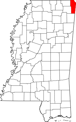
The Tishomingo County is a county in the US -amerikanischen State Mississippi . In 2010 , the county had 19,593 residents and a population density of 17.8 people per square kilometer. The county seat is Iuka , which was named after a Chickasaw chief .
geography
The county is located in the far northeast of Mississippi and borders Tennessee to the north . To the east, the Tennessee River forms part of the county's border with Alabama . Tishomingo County covers an area of 1,151 square kilometers, of which 53 square kilometers are water. The following neighboring counties border Tishomingo County:
| Alcorn County |
Hardin County, Tennessee |
Lauderdale County, Alabama |

|
Colbert County, Alabama |
|
| Prentiss County | Itawamba County |
Franklin County, Alabama |
history
Tishomingo County was formed from Chickasaw land on February 9, 1836 . It was named after a chief of the Chickasaw, a North American Indian people.
economy
In the northern part of the county on Yellow Creek of Pickwick Lake , the Tennessee Valley Authority built a nuclear power plant ( Yellow Creek Nuclear Plant ) from 1978 . After 30% had been completed, construction was stopped in 1982. In 1988 NASA began to build a rocket motor plant on the site. Due to cuts in the NASA budget, this project was abandoned in 1992. As a result, the Mississippi government and the county began to develop an industrial site on the site called the Tri-State Commerce Park. The site is developed by the Tishomingo Railroad (now Mississippi Central Railroad ) and a small port on the Tennessee-Tombigbee Waterway .
Demographic data
| Population development | |||
|---|---|---|---|
| Census | Residents | ± in% | |
| 1840 | 6681 | - | |
| 1850 | 15,490 | 131.9% | |
| 1860 | 24,149 | 55.9% | |
| 1870 | 7350 | -69.6% | |
| 1880 | 8774 | 19.4% | |
| 1890 | 9302 | 6% | |
| 1900 | 10.124 | 8.8% | |
| 1910 | 13,067 | 29.1% | |
| 1920 | 15.091 | 15.5% | |
| 1930 | 16,411 | 8.7% | |
| 1940 | 16,974 | 3.4% | |
| 1950 | 15,544 | -8.4% | |
| 1960 | 13,889 | -10.6% | |
| 1970 | 14,940 | 7.6% | |
| 1980 | 18,434 | 23.4% | |
| 1990 | 17,683 | -4.1% | |
| 2000 | 19.163 | 8.4% | |
| 2010 | 19,593 | 2.2% | |
| Before 1900 1900–1990 2000 2010 | |||

According to the 2010 census , Tishomingo County had 19,593 people in 7,709 households. The population density was 17.8 inhabitants per square kilometer. Statistically, 2.51 people lived in each of the 7709 households.
The racial the population was composed of 95.5 percent white, 3.2 percent African American, 0.4 percent Native American, 0.1 percent Asian and other ethnic groups; 0.8 percent were descended from two or more races. Hispanic or Latino of any race was 3.0 percent of the population.
22.6 percent of the population were under 18 years old, 59.1 percent were between 18 and 64 and 18.3 percent were 65 years or older. 51.6 percent of the population was female.
The median income for a household was 30,211 USD . The per capita income was $ 17,017. 20.4 percent of the population lived below the poverty line.
Localities in Tishomingo County
structure
Tishomingo County is divided into five numbered districts:
| District | Population (2010) | FIPS |
|---|---|---|
| 1 | 3945 | 28-90639 |
| 2 | 3930 | 28-91377 |
| 3 | 3850 | 28-92115 |
| 4th | 3872 | 28-92853 |
| 5 | 3996 | 28-93591 |
See also
Individual evidence
- ↑ GNIS-ID: 695791. Retrieved on February 22, 2011 (English).
- ↑ a b c U.S. Census Bureau, State & County QuickFacts - Tishomingo County, MS. Retrieved September 27, 2012
- ^ A b National Association of Counties.Retrieved September 27, 2012
- ^ US Census Bureau _ Census of Population and Housing.Retrieved February 19, 2011
- ^ Extract from Census.gov.Retrieved February 19, 2011
- ↑ Missouri Census Data Center - Mississippi ( page no longer available , search in web archives ) Info: The link was automatically marked as defective. Please check the link according to the instructions and then remove this notice. Retrieved September 27, 2012
Web links
Coordinates: 34 ° 44 ′ N , 88 ° 14 ′ W


