
Rastorf
| coat of arms | Germany map | |
|---|---|---|

|
Coordinates: 54 ° 16 ' N , 10 ° 17' E |
|
| Basic data | ||
| State : | Schleswig-Holstein | |
| Circle : | Plön | |
| Office : | Preetz country | |
| Height : | 26 m above sea level NHN | |
| Area : | 20.01 km 2 | |
| Residents: | 803 (Dec. 31, 2019) | |
| Population density : | 40 inhabitants per km 2 | |
| Postal code : | 24211 | |
| Area code : | 04307 | |
| License plate : | PLÖ | |
| Community key : | 01 0 57 066 | |
| LOCODE : | DE R2F | |
| Office administration address: | Am Berg 2 24211 Schellhorn |
|
| Website : | ||
| Mayor : | Thomas Haß (WGR) | |
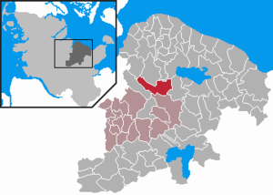
| Location of the municipality of Rastorf in the Plön district | ||
  |
||

Rastorf is a municipality in the Plön district in Schleswig-Holstein . In addition to Gut Rastorf and its former Hoheneichen Meierhof , the villages of Rosenfeld, Wildenhorst and Rastorfer Passau are located in the municipality.
Geography and traffic
Rastorf is located on the federal highway 202 about one kilometer east of Raisdorf . The white bridge over the Schwentine is one of the community's landmarks. From 1910 to 1938 Rastorf had a railway station for the Kirchbarkau – Preetz – Lütjenburg small railway .


history
The name of Rastorf comes from the Rastorf estate of the same name. The place Radesthorp (clearing village) is mentioned for the first time in 1224. In 1232 it is mentioned as Rosendahl .
The uniform, closed courtyard area of the property was created after a fire between 1720 and 1730 by the builder Rudolph Matthias Dallin . The estate has been owned by the Counts of Rantzau for many centuries .
Incorporations
On November 15, 1928, the community of Rastorfer Passau , which had only been spun off from the Rastorf manor district on March 22, 1927, and the Rastorf manor district were merged to form the new community of Rastorf. Thus, the municipal area corresponds to that of the manor district before March 22, 1927
Assignments
On September 1, 1971, an area with then about 50 inhabitants was assigned to the neighboring municipality of Raisdorf .
politics
Community representation
Of the eleven seats in the municipal council, the WGR electoral community has six seats since the 2013 local elections, the CDU three and the Rastorfer List electoral community two seats.
coat of arms
Blazon : "In the upper right with a red, silver-red split shield covered with a silver rape blossom at the upper left, a flattened wave tip in the style of a baroque gable, inside an arched bridge under a rape flower, all in mixed up colors."
economy
Rastorf is predominantly characterized by agriculture and forestry. In addition, several gravel deposits are being mined in the area of the Rastorfer Kreuz.
Sports
TSV Rastorfer Passau has existed since 1963, with its headquarters and clubhouse in Rastorfer Passau. The local soccer division trains on Mühlenberg, in the Hermann Finck Stadium, where the sports and children's festival takes place every year. Other sports, such as dancing, are played in and around the sports center.
Personalities
- Christian Graf zu Rantzau (* 1796 in Kiel, † 1857 in Rastorf), landlord of Rastorf, governor and landdrost of the Duchy of Lauenburg
Web links
Individual evidence
- ↑ North Statistics Office - Population of the municipalities in Schleswig-Holstein 4th quarter 2019 (XLSX file) (update based on the 2011 census) ( help on this ).
- ↑ Schleswig-Holstein topography. Vol. 8: Pölitz - Schönbek . 1st edition Flying-Kiwi-Verl. Junge, Flensburg 2007, ISBN 978-3-926055-89-7 , pp. 100 ( dnb.de [accessed on July 23, 2020]).
- ↑ State Statistical Office Schleswig-Holstein (Ed.): The population of the communities in Schleswig-Holstein 1867-1970 . State Statistical Office Schleswig-Holstein, Kiel 1972, p. 237 .
- ^ Federal Statistical Office (ed.): Historical municipality directory for the Federal Republic of Germany. Name, border and key number changes in municipalities, counties and administrative districts from May 27, 1970 to December 31, 1982 . W. Kohlhammer GmbH, Stuttgart / Mainz 1983, ISBN 3-17-003263-1 , p. 183 .
- ↑ Schleswig-Holstein's municipal coat of arms

Cities: Lütjenburg | Plön | Preetz | Schwentinental .
Other municipalities: Ascheberg (Holstein) | Barman | Barsbek | Behrensdorf (Baltic Sea) | Belau | Bendfeld | Blekendorf | Boksee | Bönebüttel | Bösdorf | Bothkamp | Brodersdorf | Dannau | Dersau | Dobersdorf | Dörnick | Driving | Fargau-Pratjau | Fiefbergen | Giekau | Grebin | Großbarkau | Grand Harrie | Heikendorf | Helmstorf | Högsdorf | Hohenfelde | Höhndorf | Hohwacht (Baltic Sea) | Honey lake | Calves | Kirchbarkau | Kirchnüchel | Klamp | Klein Barkau | Kletkamp | Köhn | Krokau | Krummbek | Cooling | Laboe | Lammershagen | Lebrade | Lehmkuhlen | Löptin | Lutterbek | Martensrade | Mönkeberg | Mucheln | Took | Nettelsee | Panker | Passade | Pohnsdorf | Post field | Prasdorf | Probsteierhagen | Rantzau | Rastorf | Rathjensdorf | Rendswühren | Angle of rest | Schellhorn | Schillsdorf | Reading | Schönberg (Holstein) | Schönkirchen | Schwartbuck | Selent | Stakendorf | Stone | Stumble | Stoltenberg | Tasdorf | Trundle | Wahlstorf | Wankendorf | Warnau | Wendtorf | Wipe | Wittmoldt .