
Behrensdorf (Baltic Sea)
| coat of arms | Germany map | |
|---|---|---|

|
Coordinates: 54 ° 21 ' N , 10 ° 36' E |
|
| Basic data | ||
| State : | Schleswig-Holstein | |
| Circle : | Plön | |
| Office : | Luetjenburg | |
| Height : | 7 m above sea level NHN | |
| Area : | 20.85 km 2 | |
| Residents: | 632 (December 31, 2019) | |
| Population density : | 30 inhabitants per km 2 | |
| Postal code : | 24321 | |
| Area code : | 04381 | |
| License plate : | PLÖ | |
| Community key : | 01 0 57 004 | |
| Office administration address: | Neverstorfer Strasse 7 24321 Lütjenburg |
|
| Website : | ||
| Mayor : | Manfred Krumbeck ( SPD ) | |
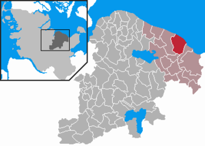
| Location of the municipality of Behrensdorf (Baltic Sea) in the Plön district | ||
  |
||

Behrensdorf (Baltic Sea) is a municipality in the Plön district in Schleswig-Holstein .
geography
Behrensdorf is located on the Hohwachter Bay , about six kilometers north of the small town of Lütjenburg , five kilometers northwest of the Baltic resort of Hohwacht and almost thirty kilometers east of the state capital Kiel .
The municipality is framed by the Kleiner Binnensee , the Großer Binnensee , the neighboring municipality of Panker and the Baltic Sea in the north.
Behrensdorf has the districts of Lippe, Seekamp, Neuland, Kembs, Waterneverstorf and Stöfs.
history
Behrensdorf was first mentioned in a document in 1433. The name of the community is probably derived from the village of Bernhard or Bernward . In the area of the community there are burial mounds and a rampart, which are not precisely determined in time.
Today's municipality of Behrensdorf was called Waterneverstorf until October 1, 1968 .
Personalities
- Friedrich Konrad Lange (1738–1791), provost in Glückstadt and Altona
coat of arms
Blazon : “Split of silver and red. In front over two blue waves a red lighthouse with golden window openings in the pointed lantern rising above a gallery. In the back, over a golden oak leaf lying to the left, an ear of the same kind. "
Attractions
The list of cultural monuments in Behrensdorf (Baltic Sea) includes the cultural monuments entered in the list of monuments of Schleswig-Holstein.
In the vicinity of the municipality are the small and large inland lakes with their dense belts of reeds, which form a retreat for numerous species of birds and are largely protected from external influences as nature reserves .
There are numerous cultural monuments in the municipality. The most notable are the Neuland lighthouse and the Waterneverstorf estate .
In the port lip is Lifeboat Woltera the DGzRS stationed.
Web links
Individual evidence
- ↑ North Statistics Office - Population of the municipalities in Schleswig-Holstein 4th quarter 2019 (XLSX file) (update based on the 2011 census) ( help on this ).
- ↑ Behrensdorf-Baltic Sea
- ↑ State Statistical Office Schleswig-Holstein (Ed.): The population of the communities in Schleswig-Holstein . Historical municipality directory: Notes on the municipality of Behrensdorf (footnote). Kiel 1972 ( digitized from genealogy.net [accessed on April 21, 2015]).
- ↑ Schleswig-Holstein's municipal coat of arms

Cities: Lütjenburg | Plön | Preetz | Schwentinental .
Other municipalities: Ascheberg (Holstein) | Barman | Barsbek | Behrensdorf (Baltic Sea) | Belau | Bendfeld | Blekendorf | Boksee | Bönebüttel | Bösdorf | Bothkamp | Brodersdorf | Dannau | Dersau | Dobersdorf | Dörnick | Driving | Fargau-Pratjau | Fiefbergen | Giekau | Grebin | Großbarkau | Grand Harrie | Heikendorf | Helmstorf | Högsdorf | Hohenfelde | Höhndorf | Hohwacht (Baltic Sea) | Honey lake | Calves | Kirchbarkau | Kirchnüchel | Klamp | Klein Barkau | Kletkamp | Köhn | Krokau | Krummbek | Cooling | Laboe | Lammershagen | Lebrade | Lehmkuhlen | Löptin | Lutterbek | Martensrade | Mönkeberg | Mucheln | Took | Nettelsee | Panker | Passade | Pohnsdorf | Post field | Prasdorf | Probsteierhagen | Rantzau | Rastorf | Rathjensdorf | Rendswühren | Angle of rest | Schellhorn | Schillsdorf | Reading | Schönberg (Holstein) | Schönkirchen | Schwartbuck | Selent | Stakendorf | Stone | Stumble | Stoltenberg | Tasdorf | Trundle | Wahlstorf | Wankendorf | Warnau | Wendtorf | Wipe | Wittmoldt .