
Geography of Berlin

The geography of Berlin is the description of the physical condition of the urban area of Berlin and its surroundings as well as the resulting interaction between this living space and its inhabitants.
Position and extent

Berlin is located in the northeast of the Federal Republic of Germany and is naturally surrounded by the North German lowlands .
Berlin's reference point, the Red City Hall , has the geographical position : 52 ° 31 ′ 7 ″ north latitude, 13 ° 24 ′ 30 ″ east longitude, the center of the city is around two kilometers south of it in Kreuzberg ( 52 ° 30 ′ 10.4 ″ N , 13 ° 24 ′ 15.1 ″ E ).
The largest expansion of the urban area in east-west direction is around 45 kilometers, in north-south direction around 38 kilometers.
The area of Berlin is 892 km². The city is completely surrounded by the state of Brandenburg .
Physical geography
topography

Berlin is located in a glacial landscape. The historic center of the city lies in the Berlin glacial valley , which crosses Berlin from the southeast to the northwest and is traversed by the Spree in an east-west direction. The north-eastern part of Berlin lies on the Barnim plateau , almost half of the urban area in the south-western area is on the Teltow plateau . The westernmost district , Spandau , is spread across the Berlin glacial valley, the Brandenburg-Potsdamer Havel area and the Zehdenick-Spandau Havel lowlands . The landscape of Berlin was created in the Ice Age during the most recent glaciation phase, the Vistula Ice Age . About 20,000 years ago the area of Berlin was covered by the Scandinavian ice sheet several hundred meters thick . When the glacier melted back , the Berlin glacial valley was formed around 18,000 years ago.
Waters
Berlin has numerous rivers and lakes. The Spree flows into the Havel in Spandau , which flows through the west of Berlin in a north-south direction. Berlin tributaries of the Spree are the Panke , Dahme , Wuhle and Erpe . The course of the river Havel, actually a glacial channel , often resembles a lake landscape; the largest bulges are the Tegeler See and the Große Wannsee . The Tegeler Fließ and Bäke brooks that flow into the Havel are partly located in Berlin . The largest lake in Berlin is the Große Müggelsee in Treptow-Köpenick .
Surveys
The highest elevations in Berlin are the highest natural ground elevation of the Great Müggelberg ( 115 m above sea level. NHN ) in the district of Treptow-Koepenick , incurred from construction waste Arkenberge ( 122 m above sea level. NHN ) in the district of Pankow , who made rubble of World War II heaped Teufelsberg ( 120 m above sea level ) in the Charlottenburg-Wilmersdorf district and the Ahrensfeld mountains ( 114 m above sea level ) in the Wuhletal landscape park in the Marzahn-Hellersdorf district . The lowest point in Berlin is at ( 28.1 m above sea level ) on the Spektesee in the Spandau district.
climate

The city is located in the temperate climate zone at the transition from the maritime to the continental climate. The average annual temperature in Berlin-Dahlem is 9.5 ° C and the average annual rainfall is 591 mm. The warmest months are July and August with an average of 19.1 and 18.2 ° C and the coldest is January with an average of 0.6 ° C. The previous maximum temperature in Berlin was measured on July 16, 2007 with a maximum temperature of 38.6 ° C at the Kaniswall station . Most of the precipitation falls in August with an average of 64 mm, the lowest in April with an average of 33 mm. (Mean values from 1981 to 2010 from the German Weather Service ) With regard to wind speeds and wind direction distribution, a two-part maximum can be recorded. According to this, north-west and south-west winds are most frequently observed in Berlin, which are associated with higher speeds, especially in winter, and mostly transports maritime , well-mixed and clean sea air.
The second maximum from the south-east and east is often characteristic of high-pressure weather conditions of continental air masses, which can lead to very hot or very cold days depending on the season. The latter weather conditions were characteristic of smog situations until the 1980s , as the pollutants produced in the city (especially from stove fires and car exhaust fumes) could not evaporate due to the poor exchange weather. The sharp decline in stove heating and the advent of exhaust filters and vehicle catalytic converters in the 1990s have significantly alleviated this problem.
| Berlin | ||||||||||||||||||||||||||||||||||||||||||||||||
|---|---|---|---|---|---|---|---|---|---|---|---|---|---|---|---|---|---|---|---|---|---|---|---|---|---|---|---|---|---|---|---|---|---|---|---|---|---|---|---|---|---|---|---|---|---|---|---|---|
| Climate diagram | ||||||||||||||||||||||||||||||||||||||||||||||||
| ||||||||||||||||||||||||||||||||||||||||||||||||
|
Monthly average temperatures and precipitation for Berlin
Source: DWD, data: 1971–2000
|
|||||||||||||||||||||||||||||||||||||||||||||||||||||||||||||||||||||||||||||||||||||||||||||||||||||||||
The small differences in altitude within the city result in a rather homogeneous urban climate . The dense development in the city and the district centers, however, leads to sometimes significant temperature differences compared to large inner-city open spaces, especially to the extensive agricultural areas in the surrounding area. Temperature differences of up to 10 ° C are measured, especially on summer nights.
Flora and fauna
flora
-2.jpg)
More than 40 percent of the urban area is green; In 2012 “439,971 trees lined the streets”. The large number of smaller open spaces, but especially the large inner-city green areas such as the Great Zoo , the Grunewald and the former Tempelhof Airport with the Hasenheide , which climatologists also refer to as "cold islands".
fauna
Species that live permanently in Berlin are u. a. Wild boars , foxes , beavers , raccoons and deer .
Nature reserves
In 2018 there were a total of 43 nature reserves in Berlin with a total area of 2,668 hectares, which corresponds to around 3.0 percent of the state's area.
In addition, there are 56 protected landscape areas , which take up another 14 percent of the country's area. In addition, the districts of Pankow and Reinickendorf have an area share of 5.4 percent in the transnational, 75,000 hectare Barnim Nature Park .
Development
The number of apartments in residential and non-residential buildings in Berlin was around 1.72 million in 1991. In 2016 there were around 1.92 million apartments in the city.
Highest building
| rank | Surname | image | Height (m) |
Construction year |
|---|---|---|---|---|
| 1 | Treptowers |

|
125 | 1995-1998 |
| 1 | Park Inn by Radisson Berlin Alexanderplatz |

|
123 | 1967-1969 |
| 3 | Steglitzer spinning top |

|
120 | 1968-1980 |
| 4th | Upper West |

|
119 | 2013-2017 |
| 5 | Zoo window |

|
119 | 2012 |
Human geography
Political structure
According to the Berlin constitution, Berlin is divided into twelve districts . These in turn are divided into 96 districts , whereby the Berlin constitution only knows a division into districts. The districts do not represent administrative units, but form the basis for official location information and therefore have administrative boundaries.
With the Greater Berlin Act in 1920, eight cities, 59 rural communities and 27 manor districts were combined. The new Greater Berlin originally comprised 20 districts with 94 districts at the time, which, with unchanged border lines, corresponded to the previous structures. Of these 20 districts, twelve were in West Berlin and eight in East Berlin after the city was divided.
On the occasion of the creation of new development areas on the eastern edge of the city - without incorporation - the number of districts in East Berlin was increased to eleven by spin-offs between 1979 and 1986. The division in West Berlin remained unchanged (except for an area swap in 1945 , when the eastern part of Groß Glienicke came to Berlin in exchange for West Staaken and became the 95th district).
In 1990, the reunified Berlin initially had 23 districts. In the Territorial Reform Act of June 10, 1998, their number was finally reduced to twelve on January 1, 2001 by means of district mergers. The number and layout of the districts have also changed several times over the past few decades.
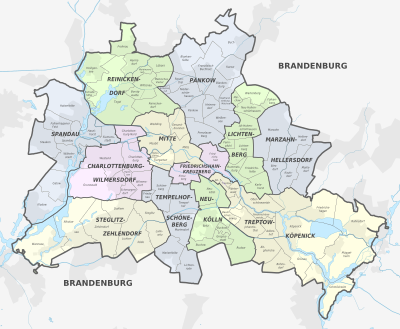
| No. | District of Berlin | Residents |
Area in km² |
Inhabitants per km² |
|---|---|---|---|---|
| 1. |
|
385,748 | 39.47 | 8,780 |
| 2. |
|
290.386 | 20.34 | 13,818 |
| 3. |
|
409.335 | 103.07 | 3,705 |
| 4th | 343,592 | 64.72 | 5,065 | |
| 5. |
|
245.197 | 91.87 | 2,519 |
| 6th |
|
310,071 | 102.56 | 2,927 |
| 7th |
|
350.984 | 53.10 | 6.334 |
| 8th. |
|
329.917 | 44.93 | 7.187 |
| 9. |
|
273,689 | 168.42 | 1,466 |
| 10. |
|
269,967 | 61.78 | 4.141 |
| 11. |
|
294.201 | 52.12 | 5.134 |
| 12. |
|
266,408 | 89.31 | 2,764 |
|
|
3,669,491 | 891.68 | 3,973 |
Neighboring cities and towns
Berlin is completely enclosed by the state of Brandenburg and borders on eight rural districts and one urban district with the following seven cities and 20 rural communities (list clockwise, starting in the northeast):

| district | cities and communes |
|---|---|
| Barnim district | Wandlitz , Panketal , Ahrensfelde |
| District of Märkisch-Oderland | Hoppegarten , Neuenhagen near Berlin |
| Oder-Spree district | Schöneiche near Berlin , Woltersdorf , Erkner (city) , Gosen-Neu Zittau |
| District of Dahme-Spreewald | Königs Wusterhausen (city) , Zeuthen , Eichwalde , Schulzendorf , Schönefeld |
| Teltow-Fläming district | Blankenfelde-Mahlow , Großbeeren |
| Potsdam-Mittelmark district | Teltow (town) , Kleinmachnow , Stahnsdorf |
| (independent city) | Potsdam (city) |
| Havelland district | Dallgow-Döberitz , Falkensee (city) , Schönwalde-Glien |
| Oberhavel district | Hennigsdorf (town) , Hohen Neuendorf (town) , Mühlenbecker Land , Glienicke / Nordbahn |
Agglomeration

The agglomeration of Berlin consists of the city of Berlin and 50 other cities and communities in the surrounding area , which are defined in the Berlin-Brandenburg State Development Plan 2009. The city-surrounding area has a population of 4.47 million inhabitants (as of December 31, 2015) on an area of 3,743.21 km². The population density is 1,194 inhabitants per square kilometer. The area has a radius of around 35 kilometers and has a slightly growing population. Outside the city of Berlin, around 950,000 people live there in an area of 2,851.46 km².
Metropolitan area
In terms of economic geography, the state of Berlin and the state of Brandenburg form the European metropolitan region of Berlin / Brandenburg . Around six million people live in the metropolitan area.
See also
Individual evidence
- ↑ The population for Berlin as a whole comes from the population update based on the 2011 census (this is the official population for Berlin), while the district numbers from the city's population register. The total of the residents of the districts can therefore differ from the population for the entire city.
- ↑ Stefan Jacobs: The highest mountain in Berlin is recently in Pankow , tagesspiegel.de, February 22, 2015 (last accessed on May 12, 2016).
- ^ First climatological assessment of the heat wave ( memento from September 23, 2015 in the Internet Archive ), German Weather Service , July 2, 2015. (offline)
- ↑ mean temperatures from 1981 to 2010 from the DWD ( memento from July 17, 2013 in the web archive archive.today ), mean precipitation from 1981 to 2010 from the DWD ( memento from June 1, 2013 in the web archive archive.today )
- ^ German Weather Service: Climate Information Berlin. World Meteorological Organization, accessed January 4, 2013 .
- ↑ Berlin Environmental Atlas, 1993/2001. (PDF; 94 kB) Senate Department for Urban Development, accessed April 16, 2010.
- ↑ Berlin Environmental Atlas, 2008. Senate Department for Urban Development, accessed on April 16, 2010.
- ↑ City trees: overviews of the existing data. Senate Department for Urban Development, accessed April 16, 2010.
- ↑ Nature reserves, overview Senate Department for Urban Development Berlin, accessed on July 31, 2018.
- ↑ Landscape protection areas Senate Department for Urban Development Berlin, accessed on July 31, 2018.
- ^ Barnim Nature Park, Berlin Senate Department for Urban Development. Retrieved July 31, 2018.
- ↑ Number of apartments in residential and non-residential buildings in Berlin from 1991 to 2016 , Statista, accessed on May 11, 2018.
- ↑ Residents in the State of Berlin on December 31, 2019, data from the Berlin-Brandenburg Statistics Office , accessed on August 27, 2020 ( PDF file ) ( help on this ).
- ↑ Berlin-Brandenburg Capital Region , www.berlin-brandenburg.de, accessed on January 17, 2016.