
Cologne rings

The Cologne Rings are a series of contiguous streets with a boulevard character that are semicircular around the old town in Cologne on the left bank of the Rhine . They are based on the course of the medieval Cologne city wall and are 7½ kilometers long.
As with the Cologne brooks, the entire street is a plural tantum . The rings are - apart from the narrow ramparts inside and outside the inner fortress ring - the innermost road ring around the old Cologne on the left bank of the Rhine. The other rings are the Innere and Äussere Kanalstraße, the Gürtel , the military ring and the Cologne motorway ring . In addition, Cologne city center is surrounded by a railway belt between Neustadt and Innere Kanalstrasse.


history


planning phase
After lengthy negotiations with the Prussian tax authorities , which had been going on since 1860 , the city discussed proposals for the first time on November 22, 1864 for the “reconstruction and expansion of the fortifications”, the walls of which are 142 to 170 meters wide. The City Council of Cologne decided on February 26, 1881 to acquire the area of the city wall and the associated military area. On May 5, 1881, the purchase contract between the City of Cologne and the War Ministry (military treasury ) became legally effective through confirmation by Reich Chancellor Otto von Bismarck , through which the city acquired the area of 122½ hectares for 11.74 million marks. The city of Cologne acquired the inner fortification ring and then tore it down so that the 104 hectare open space could be laid out as a splendid boulevard based on Parisian urban planning and Vienna's Ringstrasse . The fortifications hindered the planned expansion of the city, so that demolition created space for new developments.
Prior to this, by October 1880, as part of an urban planning competition, 27 designs for the development of this open space had been submitted, 22 of which were rejected as unusable. The remaining five designs did not meet the requirements sufficiently either, but were nevertheless awarded prizes. The first prize went to the “King Rhine” by Aachen architects Karl Henrici and Josef Stübben . Although this draft did not provide a development plan suitable for immediate implementation , it was nevertheless intended to serve as the basis for changing Cologne's Neustadt in the following years. At that time there were no models in Germany for a city expansion of the planned size (523 ha). In February 1881, a "City Expansion Deputation" was founded, the members of which were in future responsible for drawing up a development plan and implementing it. Stübben was appointed Cologne city architect on June 15, 1881. The centerpiece of the development plan presented and executed in several plan sections was the construction of the ring road.
Construction concept
The design of the rings was a major urban development project in Cologne . The construction concept was subdivided into ten construction sections, with the individual road sections each ending at places with former gate castles ( Severinstorburg , Hahnentorburg , Eigelsteintorburg ), of which important arterial roads ( Bonner Strasse , Luxemburger Strasse , Aachener Strasse and Neusser Strasse ) to the south, west and north went out. The ten sections (“chain of festive rooms”) were originally designed in different widths between 32 meters and 114 meters, partly designed as an avenue and were to be lined by representative buildings to give the character of a grand boulevard.
This ring road was supposed to connect Cologne's old town with the new town, for which Stübben laid down a regular street network with places for several churches. Another characteristic of the development plan was the diagonal system of the arterial roads. Starting from the ring road as a radial, wide diagonals were planned, which in turn were connected to each other by cross streets. This created the typical star places. The areas between the streets intended for development have been divided into building plots. The city expansions of other European metropolises, especially those of Paris and Vienna, served as a model.
Construction phase
The handover of the first part of the fortifications took place on June 9th and 10th, 1881, and on June 11th, 1881 the first part of the 700 year old city wall at Gereonstor was demolished with great solemnity . In March 1882, the first municipal land auction took place. The offer included land in the middle section of the Ringstrasse between Gereonshof and Ehrenstrasse. On April 22nd, 1882, the foundation stone was laid on the Hohenzollernring for the first building designed by De Voss & Müller , a stately tenement house owned by tax inspector Wilhelm Willmeroth ( Hohenzollernring 58 ). The land for the neighboring house, Hohenzollernring 56 , was acquired by the city master builder Stübben himself. On May 25, 1882, the section of the ring from Hahnentor to what was then Weyertor was named "Hohenstaufenring". In the meeting of the city council on May 10, 1883, the renaming of part of the Hohenstaufenring in "Habsburgerring" was decided. The actual city expansion began on November 12, 1883, increasing the area of the city by 236 hectares to 1006 hectares. The sewer system between the Bayenturm and Neusser Strasse at the security harbor was completed by November 11, 1885.
On June 11, 1886, the 7½-kilometer-long ring road was inaugurated and opened to traffic, even if many of the land was still undeveloped. The rings were mostly tree-lined, but today they have partly lost their planted median (as it still exists on the Kaiser-Wilhelm-Ring). The entire ring road was occupied by two or three rows of trees, depending on the width of the sections on a raised median or on the sidewalks . Additional green spaces were created on the particularly wide sections of the Sachsenring and Kaiser-Wilhelm-Ring as well as the German Ring (today Theodor-Heuss-Ring). The houses on Salierring had front gardens, and Barbarossaplatz was adorned with a large, round water basin with a fountain.
Important buildings
In the period after its opening, public buildings emerged on the Ringstrasse, comparable to the Parisian Grands Boulevards , whose magnificent architecture gave the Ringstrasse a metropolitan flair . Mention should be made of the building trade school on Salierring (opened on March 25, 1885), the magnificent Hohenstaufenbad building on Hohenstaufenring (July 1, 1886), the technical college on Salierring (October 30, 1886), the Museum of Applied Arts on Hansaplatz (2 May 1900), the second German commercial college on Hansaring (May 1, 1901), the opera house on Habsburgerring (September 6, 1902), the business development agency for the Rhine province on Ubierring (October 5, 1903), the engineering school on Ubierring (1. October 1904) and the Rautenstrauch-Joest Museum on the Ubierring (November 12, 1906).
Many of the buildings were only completed after the inauguration of the Ringstrasse. Construction activity in the early days after the German War of 1870/71 was extremely lively. By the end of 1889, the end of construction planning, there were 1871 houses in Neustadt, 1363 of which were on former fortress grounds and 508 on private land in the district , with the sale of which the Cologne cabbage farmers “earned a golden nose” and therefore often also villas could build on the rings. As early as April 1, 1888, the city was expanded again, reaching far beyond the rings. As early as 1898, Cologne's Ringstrasse was described as “one of the most beautiful in the world”, “because although it is kept as a uniform street, it is not of the same width and profile. Its 10 routes, which are all different in themselves, vary in width (between 32 and 130 m) and have a total length of 5,930 m. "
The churches of the Christian denominations and a new synagogue were usually not built directly on the rings (with the exception of the old Lutheran church on Sachsenring, which was destroyed in the war, and the Church of the Sacred Heart of Jesus on Zülpicher Platz), but in the small squares behind them in Neustadt (zum For example, St. Michael on Brusseler Platz , St. Paul in Vorgebirgstraße at the level of Sachsenring, the Protestant Christ Church in Herwarthstraße in the Stadtgarten and the then largest church of the Old Catholics , the parish church of the Resurrection of Christ on the star of Roon- / Moltke- / Jülicher Straße ), but they were always oriented towards the rings and not traditionally towards the east. With their imposing towers, they were focal points in the visual axes of Neustadtstrasse. A particularly well and uniformly preserved or rebuilt district of the Neustadt is located around Rathenauplatz . More important entertainment and shopping centers developed especially on the Hohenzollernring around Friesenplatz .
The rings were designed as an overall plan, but their sections from Stübben were designed as a “chain of festive rooms” due to their different furnishings and width. The Cologne-based company does not refer to this differently structured street as the Ringstrasse , but rather as the Rings . The inserted squares with their star-shaped streets made the transitions between the sections of different widths possible. Since land prices were lower for individual sections of the route, for example at the Gereon freight yard with the adjoining Cologne slaughterhouse and in the southern part of the city near the Stollwerck factory, simpler workers' residential areas developed there. The radial and diagonal streets leading from the rings were designed as residential streets.
Further structural development
The original use as a representative residential area already experienced a change in the 1920s - due to increasing road traffic - in favor of commercial use with insurance and company offices and in some areas as an entertainment district. For this purpose, parts of the original development - especially in the Kaiser-Wilhelm-Ring area - were replaced by new buildings in which the Bauhaus influence can be seen. Are u. a. the Allianz complex (Kaiser-Wilhelm-Ring 31; opened in May 1933), today's EuroHypo (Kaiser-Wilhelm-Ring 17-21) and the development of Gothaer Versicherung (Hohenzollernring 94 and the neighboring building Kaiser-Wilhelm-Ring 2-4 ; 1937).
The rings and numerous buildings were significantly destroyed in World War II. Reconstruction began in the 1950s, with the focus being more on modernization and less on preserving the historical building fabric. While the original development comprised 3 to 4 floors, today 6 to 8 floors characterize the overall picture. The original buildings are still preserved in isolated cases, which were then often adjusted to the surrounding height by means of superstructures. War-related vacant lots were largely closed, so that the rings nowadays give a rather unfragmented overall picture.
From the 1980s, under the city curator Hiltrud Kier , buildings from the 1950s were increasingly included in the monument protection catalog of the city of Cologne. The last significant change in the Hohenzollernring was made by the Gerling Ring-Karree , which was completed in 2001.
Since the presentation of the master plan Cologne by the architect Albert Speer junior at the end of 2008, considerations about a redesign of the rings have been underway. With a resolution dated May 5, 2009, the City Council of Cologne accepted the urban development master plan for Cologne city center. The Cologne master plan came to the conclusion that interventions mainly related to traffic would have reshaped or destroyed the originally clear design style of the metropolitan street. The main urban development goal was therefore defined in the master plan to achieve a coordinated, highly attractive overall design and transport concept that, in the sense of a modern classic, is extremely robust with regard to changing fashions and technical requirements. In October 2011 there were detailed proposals from planning offices as part of the guideline for Cologne Ring Roads . The aim is to reduce the street space (including parking spaces) to what is necessary for traffic purposes over the next 15 years or so and to give more space back to pedestrians and cyclists. The proportion of green space is also to be increased again. The remaining tram tracks are also to be greened.
Ring roads and squares
(from south to north)
The idea of naming the streets after German princely houses also came from Stübben. The rings and the intervening squares in the Neustadt section on the southern bank of the Rhine bear names borrowed from German history and the history of the city , they follow a homogeneous naming principle. The names of the Cologne rings symbolically come from the chronological order of the historical development of the German Empire . The city council laid down the consistent historical sequence of the ring road names in the meetings of May 10, 1883 and December 20, 1883. The sequence of the sections of the Cologne Ringstrasse from south to north (with the length of the sections): Ubierring (822 m), Karolingerring (239 m), Sachsenring (1714 m), Salierring (377 m), Hohenstaufenring (643 m), Habsburgerring (197 m), Hohenzollernring (687 m), Kaiser-Wilhelm-Ring (the widest ring with 114 meters; 771 m), Hansaring (1063 m) and Theodor-Heuss-Ring (1065 m) results in a total length of the rings of 7578 meters. The Sachsenring is the longest, the Habsburgerring is the smallest section of the rings.

Ubierring

The rings begin on the Rhine with the Ubierring, named on May 10, 1883, which reminds of the Ubier people who founded an oppidum here in Cologne , the predecessor settlement of the then Roman Colonia Claudia Ara Agrippinensium . The side streets here also bear names from the time of the clashes between Romans and Teutons . From Mainzer Straße onwards, the ring is split by a median strip designed as a park and provides space for a small green area to the banks of the Rhine. The commercial development agency for the Rhine Province until 1919, founded on October 5, 1903, was located at Ubierring No. 40. From 1920 to 1924, the new Cologne factory school building was built on the property and today it is the seat of the Cologne International School of Design . No. 45 housed the Rautenstrauch-Joest-Museum (opened on November 12, 1906), the building of which was destroyed after a direct bombing on February 28, 1945. The museum was reopened on July 7, 1967 and has been located on Cäcilienstraße since October 23, 2010. No. 48 was the former mechanical engineering school (October 1, 1904), which was reopened on May 15, 1946; today the building is used by the Cologne University of Applied Sciences .

Chlodwigplatz
.jpg)
Chlodwigplatz was named on December 20, 1883 after Clovis I , the first Merovingian attested to in Cologne . Severinstraße leads to Chlodwigplatz through Severinstor , one of the few remaining parts of the medieval city fortifications . The intersection is designed as a roundabout . To the south, Bonner Strasse and Merowingerstrasse branch off from Chlodwigplatz.
The Chlodwigplatz underground station is an important transfer point for local public transport. Three tram and four bus lines intersect here:
- Line 15: Ubierring - Chorweiler
- Line 16: Bonn Bad Godesberg - Niehl Sebastianstr.
- Line 17: Rodenkirchen - Severinsstr.
- Bus line 106: Marienburg - Heumarkt
- Bus route 132: Meschenich - Hbf
- Bus route 133: Zollstock - Hbf
- Bus route 142: Ubierring - Nippes
The traffic connection should improve with the opening of the underground north-south light rail . The tram stop on the surface was relocated from the Karolingerring to the Ubierring in autumn 2009 in order to shorten transfer routes.
The Cologne Rose Monday procession begins at Chlodwigplatz . In 1992 the big concert, Arsch huh, Zäng ussenander against right-wing violence, took place here.
Carolingian Ring
The Karolingerring, which was named on May 10, 1883 after the Frankish ruling family of the Carolingians , leads from Chlodwigplatz to Brunostraße. The comparatively short piece of the Carolingian ring is characterized by a relatively narrow cross-section. At Brunostraße the ring widens towards the Sachsenring.
Sachsenring

Johann Heinrich Schoenscheidt - City expansion Cologne, Sachsenring systems (1886)
Sachsenring 32 (1886)

Sachsenring 77–79, Mallinckrodt House (around 1890)

Sachsenring 73, Villa Arnold Guillaume (around 1900)

Sachsenring - with the old Lutheran church destroyed in World War II (1906)

Sachsenring - Diana with jumping antelope (1916)

Sachsenring 77 - Institut français


Named after the Saxon emperors on May 10, 1883 , the Sachsenring leads to the Am Trutzenberg street . In addition to the Ulrepforte, there is also a piece of the city wall with a tower, both of which are used by the Cologne carnival associations Rote- und Blaue Funken . At the Ulrepforte the north-south route leads to the rings. The villa at Sachsenring 34 was famous . In No. 77/79 there was Hermann Otto Pflaume's semi-detached house for Gustav von Mallinckrodt / Carl Johann Heinrich Scheibler with a garden by Friedrich Encke completed on August 19, 1912 . The Institut français Köln moved into the new building planned by Wilhelm Riphahn on January 15, 1953 .
Salierring

Salierring 32, Royal Building Trade School (1885)

Salierring, built in 1886

Salierring 12–20, around 1890

Salierring 32, "Rotonda"


The Salierring, named on May 10, 1883, leads to Barbarossaplatz. The most famous Salier was Heinrich IV. Underground (under the street Am Duffesbach / Am Weidenbach) the Salierring crosses the Duffesbach , the namesake of another Cologne street, the Cologne brooks .
The royal building trade school (March 25, 1885) was located in Salierring 32 in the immediate vicinity of Barbarossaplatz. Today, the "Rotonda", a circular office building with a business club on the ground floor , was completed in October 1999 . The architect Till Sattler was awarded the Architecture Prize of the Association of German Architects , local group Cologne, in September 2000 .
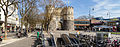
Barbarossaplatz


Former KBE train station, back of the Sparkassenhaus

Corner of Salierring

Barbarossaplatz around 1900

Swallow roof, in front of it:
Steel Watercolor Triangle Ring by
Fletcher Benton 1993


The Barbarossaplatz was born on May 10, 1883 by I. Friedrich , a Stauferkaiser named. It has largely lost its spatial effect. Instead, the traffic shapes the place. Here the tram line 18 crosses with the two ring lines 12 and 15. Until the opening of the north-south light rail line , line 16 turns to the inner city tunnel . Until the switch to light rail operations in the 1980s, the foothills railway ended southwest of Barbarossaplatz. The Luxemburger Straße crosses the rings here and merges into the street of the Cologne brooks .
For several years, various options for redesigning the square have been discussed. Among other things, there are considerations to lead line 18 underground in an extended inner city tunnel to the Eifelwall and thus to straighten out the traffic situation. For financial reasons, this project will not be able to be realized in the next few years. It is more likely that it will just be a redesign of the square.
On the square is the Bauhaus high-rise and the 12-story high-rise of the Sparkasse KölnBonn , which Ernst Nolte built in 1955/1956 with the characteristic dovetail roof.
Hohenstaufenring

Hohenstaufenring, east side (1886)

Hohenstaufenring, east side (around 1886)

Hohenstaufenring - Jahnstraße from Zülpicher Platz (around 1890)

Hohenstaufenring 57, Palais Oelbermann (around 1895)

Hohenstaufenring 62, Hohenstaufenbad (1910)


,_RBA.jpg)


The Hohenstaufenring, named on May 25, 1882, runs over the small Zülpicher Platz to Schaafenstrasse, at the end of which the Schaafentor was located until 1882 . On its east side was the Hohenstaufenbad, designed by Alfred Müller-Grah and named after this section of the ring, at No. 62, which was officially opened on July 1, 1885. The architect Hermann Otto Pflaume built a palace for the Emil Oelbermann family in Cologne's Hohenstaufenring 57 in 1889/90 . The Oelbermann family owned entire rows of houses on Hohenstaufenring, namely numbers 30, 32, 48, 50, 52 and 54.

Zülpicher Platz
.jpg)

The naming of Zülpicher Platz on July 4, 1887 was given by the city council meeting without further justification, but the motif will have been the nearby Zülpicher Straße, which was named in 1883. Southwest on Zülpicher Platz, on the corner of Zülpicher and Ring-Strasse, the foundation stone for the construction of the Herz-Jesu-Kirche was laid in 1893 . The only church building directly on the rings was designed according to plans by the architect Friedrich von Schmidt , a student of Zwirner . Since Schmidt had died in 1891, the building was erected under the direction of his son Heinrich von Schmidt and inaugurated in autumn 1895. The tower of the church was built between 1906 and 1909. The church was considerably damaged in the Second World War , only the tower was largely preserved. This and the remains of the nave were integrated into a new building between 1953 and 1957.
Habsburg ring

Habsburgerring 10–14 - (around 1888)

Habsburgerring 2, excavation of the city wall (September 2009)
Habsburgerring 9–13, Hotel Barceló Cologne (April 2013)

Habsburgerring 18–20, office and commercial building with cinema (March 2012)


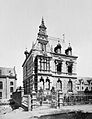
Like most sections of the ring route, the Habsburgerring got its name on May 10, 1883. The Habsburgerring, the shortest section, leads to Rudolfplatz. Its longer east side was cut through after the Second World War by the breakthrough for Richard-Wagner-Straße to Hahnenstraße and also reshaped in the rear area by partially lifting the Mauritius Wall. On March 6, 1952, the foundation stone was laid for the new headquarters building of the Sparkasse KölnBonn at Habsburgerring 2-12, the opening of which took place on November 25, 1953. The building planned by Theodor Kelter remained the address of the Sparkasse until 1992, the main entrance of which is now in the neighboring Hahnenstrasse 57. The administration of the Alwegbahn was also located in the building . When the old savings bank building was torn down, a remnant of the old city wall was found in August 2009. At Habsburgerring 18-20 there was the theater on Rudolfplatz , which was also built by Theodor Kelter with 900 seats and opened on July 7, 1956. It was closed on July 17, 1995, after which it was used from January 1999 to December 1999 for the television production tv total . Exactly opposite in nos. 9–13 was the Cologne Opera , which with its 1,800 seats was one of the largest theaters in Germany when it opened on September 6, 1902. It was badly destroyed in a bomb hit in August 1943 and the ruins were torn down in 1958 for a new building elsewhere. Between March 1959 and September 1962, Theodor Kelter built an administration building for the Provinzial Rheinland into which the Federal Administration Office and the German Investment and Development Company moved in as tenants after they were founded. The administration building was converted into a hotel between 1985 and 1988 and is now used by the Steigenberger Hotel Group after several changes of ownership (including Holiday Inn and Barceló ) .
Rudolfplatz

Rudolfplatz with Hahnentor, 2016

Rudolfplatz - Hahnentor, field side before the demolition of the city wall (1880)

Rudolfplatz - Hahnentor, horse-drawn tram (around 1890)

Rudolfplatz - Hahnentor in the snow (painting by Jakob Schreiner) Field side (with horse tram), watercolored, 1878

Rudolfplatz - Opera House (postcard, colored, around 1910)


Rudolf von Habsburg was the most important Habsburg . He is the namesake of this square, which is shaped by the Hahnentorburg , one of Cologne's medieval gate castles . The newly crowned emperors in Aachen entered the city through this gate via Aachener Strasse. Rudolfplatz has been called Hahnentorplatz since May 4, 1882, and was renamed Rudolfplatz on December 20, 1883. During the Nazi era it was called Schlageterplatz between 1933 and 1945 and was given its previous name back on April 21, 1945. In the post-war period, two corner houses dominated Rudolfplatz. These are the six-story Prinzenhof with the curved stone facade, completed by Hans Heinz Lüttgen in 1935 in Hohenzollernring 1–3, and the seven -story corner house at Hohenzollernring 2–10, planned by Wilhelm Riphahn and Paul Doetsch, which was ready for occupancy in September 1953. The Kaufhalle AG moved in here , after which the building was renovated in 1990.
Hohenzollernring
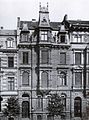
Hohenzollernring 60 (built 1883/1884)

Hohenzollernring 61 (1886); Photo: Hermann Rückwardt

Hohenzollernring - (Postcard around 1900)

Hohenzollernring - corner of Rudolfplatz (around 1900)

Hohenzollernring - corner of Limburger Strasse (around 1902)

Hohenzollernring 31–35 - Cologne Bank Headquarters (March 2010)


The Hohenzollern family are the last German emperors in the Bismarck Empire. The Hohenzollernring, named on May 4, 1882, goes from Rudolfplatz and Aachener Straße via Friesenplatz to Bismarckstraße. The house at Hohenzollernring 58 , a tenement house owned by the tax inspector Willmeroth, was the first house in Neustadt; the foundation stone was laid on April 22, 1882 . The house has not been preserved, the vacant lot is used by a drugstore with two floors. The house next to it, Hohenzollernring 56 , was built by the city planner Stübben in 1882. Because of its modest dimensions, the people of Cologne called it the house “Zum squeezed builder”. Today a health food store uses the plot. The house at Hohenzollernring 53 has also been preserved .
The "Hotel Ringhof" with the "Ring-Café" at no. 25 was acquired by the Stollwerck company in 1929 and sold the corner house in April 1956. In its place, the architect Hans Schilling built the 1963 occupied for VW dealer Jacob Fleischhauer Spectacular commercial and residential building with a trapezoidal floor plan and a widely cantilevered roof panel, which formally refers to the floor plan. In October 1970 the Cologne branch of IBM Germany moved into the newly built 13-story IBM high-rise building named after it at No. 31-35, which in April 1991 was taken over by the Cologne bank as its headquarters.
There were several traditional cinemas in the Hohenzollernring area. No. 79-81 was the Capitol , built according to plans by Jacob Koerfer , which opened on February 21, 1929 with 2,035 seats. The successor building was opened on September 28, 1954 with 1144 seats and operated by Ludwig and Hans Herbert Blatzheim . The cinema was closed on September 25, 1995, after renovation work, the Harald Schmidt Show took place here between December 1995 and August 1998 with only 700 seats, then from December 2000 to December 2003 TV total . The premises were closed in December 2005 and the building was acquired by a Swiss family office in July 2011 . In No. 22-24 there was the Ufa-Palast planned by Wilhelm Riphahn and opened in October 1931 as the largest cinema in West Germany with 3000 seats . The rubble of the war-torn building was removed in June 1954; the new building designed by the Düsseldorf architect Johannes Huhn contained a new Ufa Palace, which was opened on July 14, 1955 with 1,400 seats by godmother Caterina Valente . Starting in 1977, the cinema was divided into 13 halls by Heinz Riech as a box cinema (the smallest had 48 seats). In 2002 there was a modernization with 1226 seats and the name was changed to Filmpalast ( Cinestar Group), which was closed on March 30, 2010.
Friesenplatz
The Friesenplatz, named on May 25, 1882, opens north of the Hohenzollernring and connects to Venloer Strasse and the Belgian Quarter .
Kaiser Wilhelm Ring
.jpg)
The Kaiser-Wilhelm-Ring, named on May 4, 1882 after Wilhelm I , the first German Emperor after the unification of the Bismarck Empire , is widened like a square and equipped with trees and fountains . At 114 meters, this section of the Kaiser-Wilhelm-Ring is the widest street in Germany. Herwarthstrasse, which goes westwards, allows a view through the tower of the Christ Church near the city garden, as intended by the city planning . The Hermann-Becker-Straße, which goes diagonally at the north-west end, is named after the Lord Mayor Hermann Becker , during whose time the plans for the New Town of Cologne were drawn up and their implementation was initiated. Two historically important, no longer preserved buildings were located on Kaiser-Wilhelm-Ring 32 and Kaiser-Wilhelm-Ring 34 .
Hansaring


The Hansaring, named on May 4, 1882, leads from here to Ebertplatz. Its length also reflects the importance of Cologne as a Hanseatic city . It was an avenue street with three rows of plane trees and a footpath and bridle path on the median . From September 1, 1916 to the present day, the head office of Central Krankenversicherung is at nos. 40-50. At number 56 was the former commercial college (May 1, 1901), which is now the Hansa-Gymnasium . To the north behind the Hansaring is the Mediapark with the new landmark, the 148 m high Kölnturm, on the former site of the Gereon freight yard .
Cologne's first high-rise , the Hansa high-rise at no. 97, dates from 1924/1925. To the east is the S-Bahn station named after the Hansaring .
Hansaplatz
The Hansaplatz is a green area on the southeast side of the Hansaring, which is bounded by a 113 meter long remnant of the medieval city wall with the Gereonsmühle . The Kunstgewerbemuseum , Museum Schnütgen and Museum of East Asian Art were located at its northern end until it was destroyed in April 1944 during the Second World War . The Klingelpütz and the Klingelpützpark form its extension .

Ebertplatz
Named in March 1950 after the first Reich President Friedrich Ebert , the square is an elongated roundabout into which important roads such as the North-South Drive and Neusser Straße flow. In 1974, as part of the construction of the Ebertplatz underground station, the current square design was created. There are plans to redesign the square as such.
Theodor Heuss Ring

Theodor-Heuss-Ring 1 - ring tower

Theodor-Heuss-Ring 1 - Ringturm, extension with the Baukunst gallery

Theodor-Heuss-Ring 9 - Villa Bestgen

Theodor-Heuss-Ring - western park


The last part of the ring (formerly Deutscher Ring), named after the first Federal President Theodor Heuss on December 18, 1963, ends on the Rhine opposite the Bastei . This part is also provided with an extra wide central green area. This green corridor was built on the site of the security port, which was built between 1810 and 1813 and stretched from the Eigelstein to the Rhine. The harbor basin was 1,600 feet long and 150 to 180 feet wide. It was last expanded in 1840, but was taken out of service after 1898 when the Rheinauhafen was opened .
An Art Nouveau house (No. 9) from 1903/1904, the Villa Bestgen , was reconstructed after the war so that the original Art Nouveau elements are visible again in its exterior. It is connected to the new building from 1964 (No. 5–7) in which the Baukunst Gallery resides. House No. 1 is the 109 meter high Ringturm (Cologne) .
Art on the rings
The spacious parks and green spaces in the median of the rings and partly on the sides invited to decorate them artistically. Thus, the stationary traffic of Wolf Vostell placed on the Hohenzollernring. Fritz Behn's Diana with jumping antelope from 1916 is on the Sachsenring. In addition, the Rote Funken posted their guard at the Ulrepforte. At the Hansaring, the “Mother and Child” monument by the Dutch sculptor Mari Andriessen commemorates the victims of persecution during the Nazi era . In addition, there are a number of abstract modern metal sculptures, for example the mobile steel sculpture Steel-Watercolor-Triangle-Ring by the American Fletcher Benton from 1993 on Barbarossaplatz. But the traditional sculpture of the Sacred Heart statue on Zülpicher Platz also survived the war.
traffic

The main purpose of the Cologne Rings was to create a more straightforward traffic route on the edge of the medieval, winding old town. The flow of traffic was increased by multi-lane traffic management and partially secured by median strips. The rings are from Ebertplatz to the banks of the Rhine in the southern part of the federal road 9 .
By Frédéric de la Hault & Cie. The horse-drawn tram built first drove over the rings on November 15, 1879. On October 15, 1901, the first electric tram then ran the rings. Today's Stadtbahn Köln uses the rings through line 12 ( coming from Merkenich ) from Ebertplatz to Eifelstraße (after Zollstock to the Südfriedhof before Raderthal ), and line 15 ( coming from Chorweiler ) from Ebertplatz to Ubierring. Line 16 (from Niehl ) runs from Barbarossaplatz to Ubierring via the rings (and on the Rheinuferbahn route to Bonn ). The underground tunnel under the rings has been in use since October 1987. He closes on Hansaring to the existing tunnel from the subway station Ebertplatz and leads via the stops subway station Hansaring , underground station Christophstraße / Mediapark , friesenplatz and rudolfplatz below the previous circular path on the surface. At Zülpicher Platz, the tunnel ends at a formerly very narrow bus stop on the surface. This stop was widened in May 2006 - at the expense of the second lane for vehicles.

The Cologne Rings have been redesigned to be bike-friendly since 2016. The plan is for a complete and largely uniform cycle path from the Bayenturm to the Bastei by converting the right lane and one lane exclusively for bicycle traffic. In addition, Tempo 30 has already been ordered in large parts, the trigger for this measure is the #RingFrei initiative . Completion is planned for 2020.
literature
- Werner Schäfke : The Cologne Rings: History and Splendor of a Street (with Hiltrud Kier ); Vista-Point-Verlag Cologne 1987. ISBN 3-88973-066-3 .
- Hiltrud Kier : The Cologne Neustadt , 2 vols., Düsseldorf 1978.
- Arnold Stelzmann, Robert Frohn: Illustrated history of the city of Cologne , 11th edition. JP Bachem Verlag , Cologne 1990 (1st edition 1958), ISBN 3-7616-0973-6 .
- Rüdiger Schünemann-Steffen: Cologne Street Name Lexicon , Jörg Rüshü self-published, Cologne 1999.
- Carl Dietmar: The Chronicle of Cologne . Chronik-Verlag, Dortmund 1991, ISBN 3-611-00193-7 .
Web links
- Interest group Cologne rings
- History of the Cologne Ring Roads and the present (Masterplan of the City of Cologne) , April 2011, PDF 6.2 MB
Individual evidence
- ↑ Hans-Joachim Völse: Cologne , 2008, p. 18.
- ↑ within the medieval city wall, the city was limited to 405.45 hectares
- ↑ Peter Fuchs (Ed.): Chronicle of the History of the City of Cologne , Volume 2, 1991, p. 158
- ↑ Marko Gebert: Fortress and City of Cologne , 2013, p. 31.
- ↑ Eberhard Gothein, Georg Neuhaus: The city of Cöln in the first century under Prussian rule, 1815 to 1915 , 1916, p. 230.
- ↑ Hiltrud Kier: Die Kölner Neustadt planning, development, use , alphabetical index of streets, squares and parks , p. 123 ff.
- ^ Arnold Stelzmann, Robert Frohn: Illustrated History of the City of Cologne , 1990, p. 292 f.
- ↑ Quotation on the website of the Interest Group Ring eV ( Memento from January 5, 2010 in the Internet Archive )
- ^ Hiltrud Kier: Kleine Kunstgeschichte Kölns , Beck, Munich 2001, pp. 187–198
- ↑ Matthias Pesch: Boulevard for the 21st Century in Kölner Stadt-Anzeiger from October 11, 2011 online (accessed May 2016)
- ^ Marion Werner: From Adolf-Hitler-Platz to Ebertplatz , 2008, p. 246.
- ↑ Walther Zimmerman: Die Kunstdenkmäler des Rhineland: Supplement , Volume 23, 1978, p. 77.
- ↑ Klara van Eyll, Old address books tell , 1993, p. 158.
- ^ Rudolf Martin: Yearbook of the wealth and income of millionaires in Prussia 1912 , 1912, p. 266.
- ↑ Fred Kaufmann, Dagmar Lutz, Gudrun Schmidt-Esters: Cologne street names: Neustadt and Deutz , 1996, p. 142 f.>
- ↑ Herz Jesu und St. Mauritius - The history of the Herz-Jesu Church. (No longer available online.) Archived from the original on May 28, 2013 ; Retrieved June 7, 2013 . Info: The archive link was inserted automatically and has not yet been checked. Please check the original and archive link according to the instructions and then remove this notice.
- ↑ Fred Kaufmann, Dagmar Lutz, Gudrun Schmidt-Esters: Cologne street names . Neustadt and Deutz. Greven, Cologne 1996, ISBN 3-7743-0293-6 , pp. 143 .
- ^ Carl Dietmar: Die Chronik Kölns , 1991, p. 287.
- ↑ Walther Zimmermann: Die Kunstdenkmäler des Rheinlands , Volume 23, 1978, p. 171
- ↑ Hans Schilling, Architektur 1945–2000, 2001, p. 322
- ^ Verlagsgesellschaft R. Müller: Online: Zeitschrift für Datenverarbeitung , 1970, p. 443
- ↑ Fred Kaufmann, Dagmar Lutz, Gudrun Schmidt-Esters: Cologne street names . Neustadt and Deutz. Greven, Cologne 1996, ISBN 3-7743-0293-6 , pp. 59 .
- ^ Karl Georg Jacob, Matthias Joseph de Noël , Johann Jacob Nöggerath (anonymous): Cologne and Bonn with their surroundings. For strangers and locals. Edited from the best and especially from unused sources . Cologne, JP Bachem Verlag, 1928. Quoted and commented in: Uwe Westfehling: The first Cologne city guide from 1828 , Cologne, JP Bachem Verlag 1982, p. 160ff.
- ^ Herbert Rode: Art Guide Cologne , JP Bachem Verlag, Cologne 1966, p. 92
- ↑ Klara van Eyll : Old address books tell: Life and everyday life in Cologne , 1993, p. 87.
- ^ Carl Dietmar: Die Chronik Kölns , 1991, p. 700