
Ostheim (Haut-Rhin)
| Ostheim | ||
|---|---|---|
.svg)
|
|
|
| region | Grand Est | |
| Department | Haut-Rhin | |
| Arrondissement | Colmar-Ribeauvillé | |
| Canton | Sainte-Marie-aux-Mines | |
| Community association | Pays de Ribeauvillé | |
| Coordinates | 48 ° 10 ′ N , 7 ° 22 ′ E | |
| height | 178-186 m | |
| surface | 8.16 km 2 | |
| Residents | 1,612 (January 1, 2017) | |
| Population density | 198 inhabitants / km 2 | |
| Post Code | 68150 | |
| INSEE code | 68252 | |
| Website | http://www.ostheim.fr/ | |
 Mairie Ostheim |
||

Ostheim is a French commune with 1612 inhabitants (as of January 1, 2017) in the Haut-Rhin department in the Grand Est region (until 2015 Alsace ). She is a member of the Pays de Ribeauvillé municipal association .
geography
The municipality of Ostheim is located on the lower Fecht in the Upper Rhine Plain between Colmar and Schlettstadt .
history
From 1871 to the end of the First World War , Ostheim belonged to the German Empire as part of the realm of Alsace-Lorraine and was assigned to the district of Rappoltsweiler in the district of Upper Alsace .
After the village was almost completely destroyed in early 1945, it was rebuilt, so the appearance of the village (with the two churches and the town hall) is in the style of the early post-war period.
Population development
| year | 1910 | 1962 | 1968 | 1975 | 1982 | 1990 | 1999 | 2007 | 2017 |
| Residents | 1078 | 1306 | 1329 | 1265 | 1335 | 1335 | 1371 | 1564 | 1612 |

Protestant Church
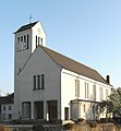
Catholic Church


Personalities
- Christian Ludwig Landbeck (born December 11, 1807 in Ostheim, † September 3, 1890 in Santiago de Chile ), German-Chilean ornithologist
literature
- Le Patrimoine des Communes du Haut-Rhin. Flohic Editions, Volume 2, Paris 1998, ISBN 2-84234-036-1 , pp. 970-971.