Nambsheim
| Nambsheim | ||
|---|---|---|

|
|
|
| region | Grand Est | |
| Department | Haut-Rhin | |
| Arrondissement | Colmar-Ribeauvillé | |
| Canton | Ensisheim | |
| Community association | Pays Rhin-Brisach | |
| Coordinates | 47 ° 56 ' N , 7 ° 34' E | |
| height | 197-208 m | |
| surface | 10.03 km 2 | |
| Residents | 586 (January 1, 2017) | |
| Population density | 58 inhabitants / km 2 | |
| Post Code | 68740 | |
| INSEE code | 68230 | |
| Website | http://www.nambsheim.fr/ | |
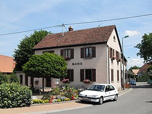
 Mairie Nambsheim |
||
Nambsheim is a French commune with 586 inhabitants (as of January 1, 2017) in the Haut-Rhin department in the Grand Est region (until 2015 Alsace ). It belongs to the Arrondissement Colmar-Ribeauvillé , the canton Ensisheim and the municipality association Pays de Brisach .
geography
The community extends in the plain west of the Upper Rhine , which forms the state border with Germany (or Baden-Württemberg ) here. It is located about 20 km south-east of Colmar and south-west of Freiburg im Breisgau . In the east, Nambsheim has a share in the Rhine side canal with the Ile de Kembs-Neuf-Brisach .
Neighboring communities
Neighboring communities are Heiteren in the north, Geiswasser in the northeast, Hartheim am Rhein (Germany) in the southeast, Balgau in the southwest and Rustenhart in the west.
history
Some tombs from Roman and Merovingian times in the municipality give evidence of a prehistoric settlement of Nambsheim. The village was first mentioned in a document towards the end of the 10th century, when Bishop Widerold of Strasbourg gave land to Nambsheim to the Benedictine Abbey of Eschau . On the former arm of the Rhine east of Nambsheim there used to be a port that was operated by the Strasbourg bishop in the abbey of Eschau in the 10th century. The village has belonged to the Habsburgs since the 13th century , who maintained a customs post here for Rhineland trade and were housed in Zollbühl Castle (today: Motte du Péage ). It was actually about Nambsheim Castle , which was first mentioned in the 16th century and disappeared from the documents in the 19th century. In 1389 - now the village was a fiefdom of Wernher von Ratolzdorf - Nambsheim was plundered by Bernhard von Beblenheim. In 1513 the imperial treasurer Jakob Villinger von Schönenberg bought the castle and a large part of the village.
As early as 1536, the widow of the imperial treasurer sold the village's goods to the city of Colmar , which they sold on to Peter Scheer from Schwartzenberg. As a result, Nambsheim gradually passed into the hands of the noble families von Landeck, von Rappoltstein , von Klug, von Greiff, von Schauenberg and von Anthes. After the sovereignty had changed from the German Empire to France in the second half of the 17th century, while maintaining the existing feudal rule, the French central administration was introduced in 1789.
From 1871 until the end of the First World War , Nambsheim belonged to the German Empire as part of the realm of Alsace-Lorraine and was assigned to the Colmar district in the Upper Alsace district . In 1910, 355 residents were registered in Nambsheim. During the Second World War , the population was evacuated to Bouglon ( Département Lot-et-Garonne ) in 1939 and liberated from German occupation in 1945. In the course of its history, the Alsatian village fell victim to major fires several times , for example in 1632, 1914, 1615, 1790 and 1915.
Population development
| year | 1962 | 1968 | 1975 | 1982 | 1990 | 1999 | 2007 | 2014 |
|---|---|---|---|---|---|---|---|---|
| Residents | 259 | 261 | 341 | 346 | 345 | 406 | 555 | 602 |
Attractions
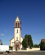
The church of St. Stephan ( Saint-Étienne ) dates from the 19th century, the current church tower was built in 1937.
economy
For decades, Nambsheim was particularly characterized by traditional cattle and pig breeding and the cultivation of grain. In the meantime, an equally important industrial area has emerged. The renowned chemical company DuPont de Nemours has set up a research center there that is active in the field of products for sustainable development aid.
Transport links
Département roads 52 (east of the village parallel to the Rhine) and 468 run through the municipality. The federal motorway 5 is a supra-regional traffic artery directly on the other side of the Rhine in Germany. The Hartheim / Heitersheim junction there is only 5 km south-east of Nambsheim and is easily accessible via the Rhine bridge near Fessenheim, which was opened in 2006, but which was closed to heavy goods traffic, so that the town as a whole is very well connected to the road network.
literature
- Le Patrimoine des Communes du Haut-Rhin. Flohic Editions, Volume 2, Paris 1998, ISBN 2-84234-036-1 , p. 928.
Individual evidence
- ↑ Municipal directory Germany 1900 - Colmar district ( Memento of the original from February 21, 2016 in the Internet Archive ) Info: The archive link was inserted automatically and has not yet been checked. Please check the original and archive link according to the instructions and then remove this notice.


