Breitenbach-Haut-Rhin
| Breitenbach-Haut-Rhin | ||
|---|---|---|

|
|
|
| region | Grand Est | |
| Department | Haut-Rhin | |
| Arrondissement | Colmar-Ribeauvillé | |
| Canton | Wintzenheim | |
| Community association | Vallée de Munster | |
| Coordinates | 48 ° 1 ′ N , 7 ° 6 ′ E | |
| height | 414-1,165 m | |
| surface | 9.27 km 2 | |
| Residents | 828 (January 1, 2017) | |
| Population density | 89 inhabitants / km 2 | |
| Post Code | 68380 | |
| INSEE code | 68051 | |
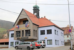
 Mairie Breitenbach-Haut-Rhin |
||
Breitenbach-Haut-Rhin ( Braiteba in Alsace ) is a French commune with 828 inhabitants (as of January 1, 2017) in the Vallée de Munster in the Haut-Rhin department in the Grand Est region (until 2015 Alsace ). Breitenbach-Haut-Rhin is a member of the Association of Municipalities Vallée de Munster .
geography
The surrounding area, which is part of the Vosges Mountains, is largely forested and is part of the Ballons des Vosges Regional Nature Park . The Oberbreitenbach district is south of the village center . It is about 24 kilometers to Colmar to the east . The D10 department road and the Colmar – Metzeral railway line run through the village .
There is a German military cemetery in Breitenbach , where 3,528 soldiers who fell from both world wars were buried.
history
The place was first mentioned in the 13th century. During the First World War , 70% of the place was destroyed, which also affected the community archive. In the winter of 1944/45 the area was liberated by American troops. A beachhead battle broke out around Colmar .
Population development
| year | 1962 | 1968 | 1975 | 1982 | 1990 | 1999 | 2007 | 2017 |
|---|---|---|---|---|---|---|---|---|
| Residents | 849 | 837 | 862 | 835 | 854 | 879 | 874 | 828 |
| Sources: Cassini and INSEE | ||||||||
literature
- Le Patrimoine des Communes du Haut-Rhin. Flohic Editions, Volume 2, Paris 1998, ISBN 2-84234-036-1 , p. 879.

