
Bergheim (Haut-Rhin)
| Bergheim | ||
|---|---|---|
.svg)
|
|
|
| region | Grand Est | |
| Department | Haut-Rhin | |
| Arrondissement | Colmar-Ribeauvillé | |
| Canton | Sainte-Marie-aux-Mines | |
| Community association | Pays de Ribeauvillé | |
| Coordinates | 48 ° 12 ' N , 7 ° 22' E | |
| height | 172-733 m | |
| surface | 19.16 km 2 | |
| Residents | 2,121 (January 1, 2017) | |
| Population density | 111 inhabitants / km 2 | |
| Post Code | 68750 | |
| INSEE code | 68028 | |
| Website | http://www.ville-bergheim.fr/ | |
 Aerial view of Bergheim, view from the east |
||

Bergheim is a French commune with 2,121 inhabitants (as of January 1, 2017) in the Haut-Rhin department in the Grand Est region (until 2015 Alsace ). She is a member of the Pays de Ribeauvillé municipal association .
Bergheim has a completely surrounding double city wall with numerous defense towers and a city gate , the upper gate, from the 14th century. The second city gate at the other end of the city no longer exists.
geography
Bergheim is located between Colmar (16 km south) and Schlettstadt (11 km north) in the Upper Rhine Plain . The town is a typical wine village with two well-known vineyards, the Altenberg de Bergheim and the Kanzlerberg . It is on the Alsace Wine Route . The municipality is part of the Ballons des Vosges Regional Nature Park .
history
Bergheim was already settled in Roman times. In 1848 a large mosaic of that time was uncovered (today in the Musée d'Unterlinden in Colmar), and then another in 2006.
In the Middle Ages, Bergheim was a free city under the rule of Rappoltstein . In 1313 the city received the right to mint money and levy customs duties.
From 1871 until the end of the First World War , Bergheim belonged to the German Empire as part of the realm of Alsace-Lorraine and was assigned to the district of Rappoltsweiler in the district of Upper Alsace .
Place name
The place name has undergone several changes in the course of history:
- Berchem, during the Frankish period (465)
- Bercheim (1302)
- Berckheim (1510)
- Bercken (1576)
Population development
| year | 1910 | 1962 | 1968 | 1975 | 1982 | 1990 | 1999 | 2007 | 2017 |
|---|---|---|---|---|---|---|---|---|---|
| Residents | 1956 | 1708 | 1753 | 1703 | 1774 | 1802 | 1830 | 1860 | 2121 |
| Source: Municipal directory, Cassini and INSEE | |||||||||
Attractions
- The double city wall, which completely encloses the place, with numerous defensive towers and the western upper gate as a city gate was built in the 14th century and renewed in the 16th century. The eastern sub-gate no longer exists. The kennel between the two city walls is now occupied by private gardens. The outer city wall is completely accessible. The inner city wall consists of the outer walls of the town houses.
- The parish church of Notre-Dame de l'Assomption (Assumption of Mary) was built from 1320 to 1347, the interior was redesigned in 1718 in Baroque style. The side chapel and sacristy are neo-Gothic . The tympanum shows an adoration of the kings . In 1959, frescoes from 1480 were rediscovered during a restoration . The large Rinkenbach organ from 1903 was built into a neo-baroque case from 1879, but with original sculptures from 1740.
- The town hall dates from 1767.
- The synagogue was built between 1860 and 1863. It replaced the medieval synagogue (around 1300), which had been destroyed by fire in 1840.
- According to an inscription there, a festival is said to have been celebrated as early as 1300 under the old village linden tree . Their trunk diameter is 1.80 meters.
- The Reichenberg Castle (13./20. Century) is privately owned.
- In the German military cemetery , 5,308 German soldiers killed in World War II are buried. They were reburied here from 1970–1975 from more than 225 communities in Upper Alsace.

Obertor
front view
Obertor
rear view
City wall
with towers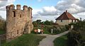
Tower and house
on the city wall
Tower with bay window

Maximinus Chapel

Main Street
(Grand Rue)
Church of the Assumption

Town Hall ( Hôtel de ville )

synagogue

German military cemetery


Personalities
- Johannes Fabricius Montanus (1527–1566), reformed clergyman, poet and universal scholar, was born in Bergheim.
literature
- Le Patrimoine des Communes du Haut-Rhin. Flohic Editions, Volume 2, Paris 1998, ISBN 2-84234-036-1 , pp. 951-955.
Web links
- Website of the municipality (French)
- History and description of the city (German)
- The church organ (French)
- Parish Church of the Assumption (French)
- Illustration by Daniel Meisner from 1625: Berck; Non Ridente Fortuna ( digitized version )