
Hohrod
| Hohrod | ||
|---|---|---|
.svg)
|
|
|
| region | Grand Est | |
| Department | Haut-Rhin | |
| Arrondissement | Colmar-Ribeauvillé | |
| Canton | Wintzenheim | |
| Community association | Vallée de Munster | |
| Coordinates | 48 ° 3 ' N , 7 ° 8' E | |
| height | 391–1,040 m | |
| surface | 5.49 km 2 | |
| Residents | 365 (January 1, 2017) | |
| Population density | 66 inhabitants / km 2 | |
| Post Code | 68140 | |
| INSEE code | 68142 | |
| Website | http://hohrod.fr | |
 Mairie Hohrod |
||

Hohrod is a French commune with 365 inhabitants (as of January 1, 2017) in the Haut-Rhin department in the Grand Est region (until 2015 Alsace ). It belongs to the arrondissement of Colmar-Ribeauvillé , the canton of Wintzenheim and is a member of the Vallée de Munster community association .
geography
The Vosges community of Hohrod is located on the pass road that leads from the Fechttal over the Collet du Linge and the Col du Wettstein into the Weisstal .
The municipality belongs to the regional nature park "Ballons des Vosges" . In the northeast the main road passes the Hohrodberg. The next neighboring village of Hohrod is Weier in the southwest.
history
Hoenrod is mentioned for the first time in the 13th century . The name is likely derived from clearing the forest. A corresponding document dates from 1847; At that time Alsace was still predominantly German-speaking.
During the First World War , Hohrod was the site of heavy fighting. There is therefore also a German military cemetery in the municipality .
| year | 1962 | 1968 | 1975 | 1982 | 1990 | 1999 | 2007 | 2017 |
| Residents | 282 | 284 | 305 | 318 | 293 | 320 | 343 | 365 |

German military cemetery
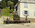
Well in Hohrod


economy
Tourism plays an important role in Hohrod .
literature
- Le Patrimoine des Communes du Haut-Rhin. Flohic Editions, Volume 2, Paris 1998, ISBN 2-84234-036-1 , p. 885.