Roggenhouse
| Roggenhouse | ||
|---|---|---|

|
|
|
| region | Grand Est | |
| Department | Haut-Rhin | |
| Arrondissement | Colmar-Ribeauvillé | |
| Canton | Ensisheim | |
| Community association | Pays Rhin-Brisach | |
| Coordinates | 47 ° 53 ' N , 7 ° 28' E | |
| height | 213-219 m | |
| surface | 6.45 km 2 | |
| Residents | 469 (January 1, 2017) | |
| Population density | 73 inhabitants / km 2 | |
| Post Code | 68740 | |
| INSEE code | 68281 | |
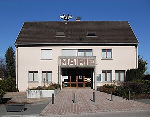
 Town Hall (Mairie) |
||
Roggenhouse (German Roggenhausen ) is a French commune with 469 inhabitants (as of January 1, 2017) in the Upper Rhine Valley in the Haut-Rhin department in the Grand Est region (until 2015 Alsace ). The inhabitants call themselves les Roggenhousiens .
geography
The community of Roggenhouse is located on the Rhine-Rhône Canal , about 20 kilometers northeast of Mulhouse on the edge of the Harthwald forest .
Neighboring communities of Roggenhouse are Fessenheim in the northeast, Blodelsheim in the east, Rumersheim-le-Haut in the southeast, Munchhouse in the south and Hirtzfelden in the northwest.
history
From 1871 until the end of the First World War , Roggenhouse belonged to the German Empire as part of the realm of Alsace-Lorraine and was assigned to the Gebweiler district in the Upper Alsace district .
Population development
| 1910 | 1962 | 1968 | 1975 | 1982 | 1990 | 1999 | 2006 | 2016 |
|---|---|---|---|---|---|---|---|---|
| 212 | 186 | 205 | 231 | 317 | 377 | 396 | 462 | 470 |
Administration union
Roggenhouse is a member of the cross- border local association Mittelhardt-Oberrhein , which promotes cross-border communal cooperation between municipalities in Alsace and Baden on the basis of the Karlsruhe Convention .
Attractions
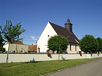
- Saint-Wendelin Church, built in 1704
- Peace Chapel
literature
- Le Patrimoine des Communes du Haut-Rhin. Flohic Editions, Volume 1, Paris 1998, ISBN 2-84234-036-1 , p. 381.
Individual evidence
- ↑ Municipal directory Germany 1900 - Gebweiler district
- ↑ http://www.gemeinde-eschbach.de/wirtschaftsstandort/glct_goez.php


