
Dessenheim
| Dessenheim | ||
|---|---|---|
.svg)
|
|
|
| region | Grand Est | |
| Department | Haut-Rhin | |
| Arrondissement | Colmar-Ribeauvillé | |
| Canton | Ensisheim | |
| Community association | Pays Rhin-Brisach | |
| Coordinates | 47 ° 59 ′ N , 7 ° 29 ′ E | |
| height | 197-207 m | |
| surface | 19.16 km 2 | |
| Residents | 1,420 (January 1, 2017) | |
| Population density | 74 inhabitants / km 2 | |
| Post Code | 68600 | |
| INSEE code | 68069 | |
| Website | http://www.habenheim.fr | |
 Town Hall (Mairie) |
||

Dessenheim (Alsatian Dassene ) is a French commune with 1,420 inhabitants (as of January 1, 2017) in the Haut-Rhin department in the Grand Est region (until 2015 Alsace ). It belongs to the canton of Ensisheim and to the Communauté de communes Pays Rhin-Brisach .
geography
Dessenheim is located in the Upper Rhine Plain between the Ill and the Rhine , around 17 kilometers southeast of Colmar .
history
From 1871 until the end of the First World War , Dessenheim belonged to the German Empire as part of the realm of Alsace-Lorraine and was assigned to the district of Colmar in the district of Upper Alsace .
Population development
| year | 1910 | 1962 | 1968 | 1975 | 1982 | 1990 | 1999 | 2007 | 2017 |
| Residents | 969 | 698 | 756 | 817 | 830 | 928 | 1052 | 1169 | 1420 |
Attractions
- Saint-Léger church
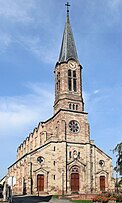
Northwest side 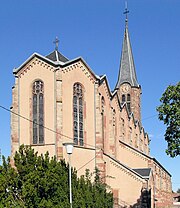
West side


inside view 
organ


literature
- Le Patrimoine des Communes du Haut-Rhin. Flohic Editions, Volume 2, Paris 1998, ISBN 2-84234-036-1 , pp. 919-920.
Web links
Commons : Dessenheim - Collection of images, videos and audio files