
Patsch (Tyrol)
|
Slap
|
||
|---|---|---|
| coat of arms | Austria map | |
 |
|
|
| Basic data | ||
| Country: | Austria | |
| State : | Tyrol | |
| Political District : | Innsbruck country | |
| License plate : | IL | |
| Surface: | 9.7 km² | |
| Coordinates : | 47 ° 12 ' N , 11 ° 25' E | |
| Height : | 998 m above sea level A. | |
| Residents : | 1,056 (January 1, 2020) | |
| Postal code : | 6082 | |
| Area code : | 0512 | |
| Community code : | 7 03 38 | |
| NUTS region | AT332 | |
| Address of the municipal administration: |
Dorfstrasse 22 6082 Patsch |
|
| Website: | ||
| politics | ||
| Mayor : | Andreas Danler (Mayor list Patsch) | |
|
Municipal Council : (2016) (13 members) |
||
| Location of Patsch in the Innsbruck-Land district | ||
  |
||
 Slap from the southwest |
||
| Source: Municipal data from Statistics Austria | ||


Patsch is a municipality with 1056 inhabitants (as of January 1, 2020) in the Innsbruck-Land district in Tyrol ( Austria ). The municipality is located in the judicial district of Innsbruck .
geography
Patsch is located on the low mountain range at the entrance of the Wipptal , at the foot of the Patscherkofel south of Innsbruck. In addition to the church village on the old salt road , the municipality includes the districts of Kehr, Rinnerhöfe (Pfrauns), Sillwerk, Ruggschrein, Ahren and Bahnhof. The highest point in the community is the Patscherkofel at 2246 m. Ruggschrein used to be a customs post on the important salt road leading from Hall in Tirol to Matrei .
The Rosengarten nature reserve is easily accessible through several north-south-oriented walking and field paths along the terraced steps that start from Patsch or the Grünwalder Hof. The protected area is one of the local recreation areas in the catchment area of Innsbruck. One of the attractions in this area is the archaeological site at Goldbichl (which is already part of the Innsbruck municipality) .
Community structure
Patsch consists of a single cadastral municipality and village of the same name .
|
structure
|
||||||
|
Legend for the breakdown table
|
Neighboring communities
All four neighboring communities of Patsch are in the Innsbruck-Land district.
| innsbruck | Lans | |
.svg)
|
||
| Schönberg in the Stubai Valley | Elbows |
history
Patsch is considered to be the oldest village in the southern low mountain range, many field names indicate pre-Roman or Roman times settlement. The oldest documented mention refers to Pfrauns (Rinnerhöfe), which appears in the ownership records of Dießen Monastery as "Amfrun" and "Amphrun" around 1150/57 . Patsch is first mentioned in a document around 1200 as "Patsche" and "Pats" . In the early Middle Ages, the place was the center of a market cooperative and a mother parish . In 1256 it was incorporated into Wilten Abbey .
The construction of the Brennerbahn from 1864 to 1867 brought wealth to the community through the removal of land. The Obere Sill power plant, built in 1903 under Josef Riehl and located in the Patscher and Schönberger area, was at that time the largest power plant of the Austro-Hungarian monarchy.
Another important building is below the Silltal spanning 1963 finished Europe bridge .
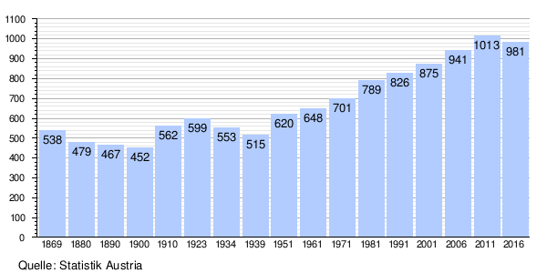
Population development
Culture and sights
- The parish church of St. Donatus was built in 1479 in the Gothic style after a fire in 1399, which includes the village fell victim and Baroque 1767th
- The Grünwalderhof inn on the road to Igls was mentioned in a document around 1500.
Economy and Infrastructure
traffic

Patsch was already on an important traffic route in pre-Roman times. Indications that this traffic route was also heavily frequented in the Middle Ages, especially as the salt road from Hall to the south, was found in 1994 during canal construction work in front of the old Altwirt inn, which has now been demolished. A stone-paved road with deep ruts came to light during the excavation work. The stones were laid in the original way to the north of the Patscher elementary school. At the "Zollerhof" customs were levied. Located directly on the old Roman road, the Bär inn was an important trading and resting station for merchants as early as the 12th century; In 1809, Andreas Hofer met here several times with Josef Speckbacher for strategic meetings.
Patsch can be reached by traffic via the A 13 Brenner motorway with its own exit (exit 7) and from the south-western low mountain range with a road from Igls and Ellbögen (Patscher Straße L 33 and Ellbögener Straße L 38).
The Patsch der Brennerbahn station is about 200 meters below the town center in the Sill Gorge. The station buildings were demolished as part of the Brenner Railway renovation in August 2012 after the monument protection was lifted. Today four trains stop here on working days (two in each direction). The regional bus routes 4132 and 4141, which connect Patsch with Innsbruck, are more important for public transport.
The Patscherkofelbahn is a gondola cable car that leads from the 300 m elevated Innsbruck district of Igls to almost 300 m below the summit of the Patscherkofel. The mountain station is in Patsch. Due to a renovation that has been ongoing since April 2017, the route will change slightly and the cable car will be closed from October 23 to December 15, 2017.
politics
The last mayoral elections took place at the same time as the municipal council elections on February 28, 2016. Andreas Danler was elected mayor with 441 votes / 62.38%.
| Political party | percent | be right | Seats on the local council | Coupling |
|---|---|---|---|---|
| Mayor list Patsch | 54.65% | 376 | 7th | |
| Future slap | 45.35% | 312 | 6th |
Personalities
Sons and daughters of the church
- Rupert Reindl (1908–1990), sculptor and nativity scene carver
Personalities associated with the community
- Johannes Jobst (1920–2014), bishop
Web links
- 70338 - Slap. Community data, Statistics Austria .
- History-Tyrol: Patsch
- www.patsch.gv.at - homepage of the community
Individual evidence
- ↑ Martin Bitschnau , Hannes Obermair : Tiroler Urkundenbuch, II. Department: The documents on the history of the Inn, Eisack and Pustertal valleys. Volume 2: 1140-1200 . Universitätsverlag Wagner, Innsbruck 2012, ISBN 978-3-7030-0485-8 , p. 70-71, no. 462 .
- ↑ Municipal council and mayoral elections 2016 - Patsch municipality , accessed on May 4, 2016
City: Hall in Tirol . Market communities: Fulpmes • Matrei am Brenner • Steinach am Brenner • Völs • Wattens • Zirl . Municipalities: Absam • Aldrans • Ampass • Axams • Baumkirchen • Birgitz • Ellbögen • Flaurling • Fritzens • Gnadenwald • Götzens • Gries am Brenner • Gries im Sellrain • Grinzens • Gschnitz • Hatting • Inzing • Kematen in Tirol • Kolsass • Kolsassberg • Lans • Leutasch • Mieders • Mils • Mühlbachl • Mutters • Natters • Navis • Neustift im Stubaital • Oberhofen im Inntal • Obernberg am Brenner • Oberperfuss • Patsch • Pettnau • Pfaffenhofen • Pfons • Polling in Tirol • Ranggen • Reith bei Seefeld • Rinn • Rum • St. Sigmund im Sellrain • Scharnitz • Schmirn • Schönberg im Stubaital • Seefeld in Tirol • Sellrain • Sistrans • Telfes im Stubai • Telfs • Thaur • Trins • Tulfes • Unterperfuss • Vals • Volders • Wattenberg • Wildermieming .
Cadastral municipality and locality: Patsch
Villages:
Patsch |
Weiler:
Kehr •
Rinnerhöfe |
Settlements:
Gänsbichl •
Sillwerk •
Zoller |
Groups of houses:
Klimahaus am Patscherkofel •
Ruggschrein |
Scattered houses:
Patscherkofel |
Other locations:
Europabrücke •
Magdalenakapelle •
Patsch train station •
Patscherkofelhaus
Almen:
Patscher Alm
Counting district: Patsch