Pfalzweyer
| Pfalzweyer | ||
|---|---|---|

|
|
|
| region | Grand Est | |
| Department | Bas-Rhin | |
| Arrondissement | Saverne | |
| Canton | Ingwiller | |
| Community association | Hanau-La Petite Pierre | |
| Coordinates | 48 ° 48 ' N , 7 ° 16' E | |
| height | 240-322 m | |
| surface | 2.23 km 2 | |
| Residents | 321 (January 1, 2017) | |
| Population density | 144 inhabitants / km 2 | |
| Post Code | 67320 | |
| INSEE code | 67373 | |
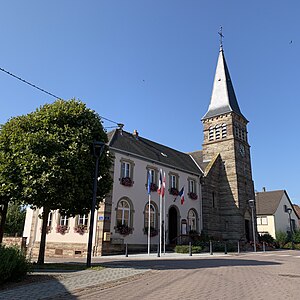
 Town hall and church |
||
Pfalzweyer (German Pfalzweier ) is a French commune with 321 inhabitants (as of January 1, 2017) in the Bas-Rhin department in the Grand Est region (until 2015 Alsace ).
geography
Pfalzweyer is a street village ; most of the houses are on rue Principale . In the southwest, the village is touched by the border with the Moselle department . In the north the community has a share in the valley of the Moselle . It is also involved in the Palatinate Forest-Vosges du Nord biosphere reserve .
history
The place name, which still exists today, first appeared in a document from 1589.
From 1871 until the end of the First World War , Pfalzweyer belonged as part of the realm of Alsace-Lorraine to the German Empire and was assigned to the district of Zabern in the district of Lower Alsace .
Population development
| 1910 | 1962 | 1968 | 1975 | 1982 | 1990 | 1999 | 2006 | 2012 | 2014 |
|---|---|---|---|---|---|---|---|---|---|
| 324 | 307 | 309 | 307 | 288 | 307 | 309 | 283 | 321 | 314 |
Attractions
- The Protestant church was built in 1860/61 and the bell tower was rebuilt in sandstone after it was destroyed in 1867.
literature
- Le Patrimoine des Communes du Bas-Rhin. Flohic Editions, Volume 2, Charenton-le-Pont 1999, ISBN 2-84234-055-8 , pp. 968-969.
