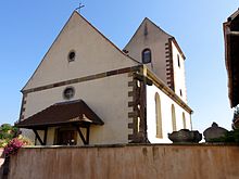
Kienheim
| Kienheim | ||
|---|---|---|

|
|
|
| region | Grand Est | |
| Department | Bas-Rhin | |
| Arrondissement | Saverne | |
| Canton | Bouxwiller | |
| Community association | Kochersberg | |
| Coordinates | 48 ° 41 ′ N , 7 ° 35 ′ E | |
| height | 184-275 m | |
| surface | 3.18 km 2 | |
| Residents | 553 (January 1, 2017) | |
| Population density | 174 inhabitants / km 2 | |
| Post Code | 67270 | |
| INSEE code | 67236 | |
 Mairie Kienheim |
||
Kienheim is a French commune with 553 inhabitants (as of January 1, 2017) in the Bas-Rhin department in the Grand Est region (until 2015 Alsace ). It belongs to the canton of Truchtersheim and to the Kochersberg community association founded in 2001 . On January 1, 2015, the municipality moved from the Arrondissement Strasbourg-Campagne to the Arrondissement Saverne .
The Kienheim settlement in Kochersberg was the ancestral seat of the Kuenheim family . A street connects Kienheim with the neighboring towns of Durningen in the southwest and Gimbrett (municipality of Berstett ) in the northeast.
Population development
| year | 1962 | 1968 | 1975 | 1982 | 1990 | 1999 | 2006 | 2017 |
| Residents | 173 | 175 | 203 | 516 | 538 | 519 | 632 | 553 |
See also
literature
- Le Patrimoine des Communes du Bas-Rhin. Flohic Editions, Volume 2, Charenton-le-Pont 1999, ISBN 2-84234-055-8 , pp. 1444-1445.
Web links
Commons : Kienheim - collection of images, videos and audio files
- Community presentation (French)

