Altwiller
| Altwiller | ||
|---|---|---|

|
|
|
| region | Grand Est | |
| Department | Bas-Rhin | |
| Arrondissement | Saverne | |
| Canton | Ingwiller | |
| Community association | Alsace Bossue | |
| Coordinates | 48 ° 56 ' N , 6 ° 59' E | |
| height | 215-266 m | |
| surface | 16.22 km 2 | |
| Residents | 395 (January 1, 2017) | |
| Population density | 24 inhabitants / km 2 | |
| Post Code | 67260 | |
| INSEE code | 67009 | |
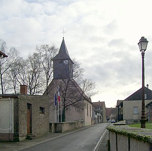
 Altwiller Protestant Church, built in 1723/24 |
||
Altwiller ( German Altweiler ) is a French commune with 395 inhabitants (as of January 1, 2017) in the Bas-Rhin department in the Grand Est region (until 2015 Alsace ).
geography
The municipality of Altwiller is located in Crooked Alsace , about ten kilometers west of Sarre-Union and is the westernmost municipality of the Bas-Rhin department. The river La Rose forms the border to the Moselle department in the northwest , and the municipal border runs along the Upper Saar in the southeast . Altwiller is surrounded by the neighboring communities of Vittersbourg and Honskirch in the north-west, Hinsingen in the north, Bissert in the north-east, Harskirchen in the east, Diedendorf in the south-east, Niederstinzel in the south (point of contact) and Vibersviller in the south-west and west.
coat of arms
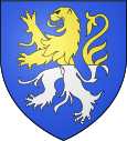
Blazon : "In blue, a lion divided into gold and silver ."
Population development
| year | 1962 | 1968 | 1975 | 1982 | 1990 | 1999 | 2007 | 2017 |
| Residents | 474 | 456 | 416 | 414 | 415 | 399 | 413 | 395 |
| Sources: Cassini and INSEE | ||||||||
See also
literature
- Le Patrimoine des Communes du Bas-Rhin. Flohic Editions, Volume 2, Charenton-le-Pont 1999, ISBN 2-84234-055-8 , pp. 1063-1065.
