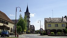
Keskastel
| Keskastel | ||
|---|---|---|

|
|
|
| region | Grand Est | |
| Department | Bas-Rhin | |
| Arrondissement | Saverne | |
| Canton | Ingwiller | |
| Community association | Alsace Bossue | |
| Coordinates | 48 ° 58 ' N , 7 ° 3' E | |
| height | 209-275 m | |
| surface | 18.87 km 2 | |
| Residents | 1,520 (January 1, 2017) | |
| Population density | 81 inhabitants / km 2 | |
| Post Code | 67260 | |
| INSEE code | 67234 | |
Keskastel is a French commune with 1520 inhabitants (as of January 1, 2017) in the Bas-Rhin department in the Grand Est region (until 2015 Alsace ).
geography
Keskastel is located in the north of the Bas-Rhin department on the banks of the Saar and borders on Herbitzheim and Sarralbe in the north, and Schopperten and Sarre-Union in the south .
coat of arms
Coat of arms Description : In gold a brick red crenellated wall with a closed gate and right salaried crenellated tower .
Population development
| year | 1962 | 1968 | 1975 | 1982 | 1990 | 1999 | 2007 | 2012 | 2014 |
| Residents | 1.306 | 1,366 | 1,297 | 1,316 | 1,362 | 1,438 | 1,541 | 1,612 | 1,557 |
Economy and Infrastructure
traffic
Keskastel is on the N61 (Phalsbourg – Saarbrücken), the D338 and the D92. The place borders on the E25 , but does not have its own connection. The Keskastel stop is on the Berthelming – Sarreguemines railway line .
tourism
The community has its own campsite with a swimming lake and fishing opportunities. Keskastel is on the Saar hiking trail .
See also
literature
- Le Patrimoine des Communes du Bas-Rhin. Flohic Editions, Volume 2, Charenton-le-Pont 1999, ISBN 2-84234-055-8 , pp. 1077-1079.

