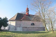
Podmoky u Městce Králové
| Podmoky | ||||
|---|---|---|---|---|
|
||||
| Basic data | ||||
| State : |
|
|||
| Region : | Středočeský kraj | |||
| District : | Nymburk | |||
| Area : | 847 ha | |||
| Geographic location : | 50 ° 12 ' N , 15 ° 14' E | |||
| Height: | 219 m nm | |||
| Residents : | 195 (Jan 1, 2019) | |||
| Postal code : | 289 04 | |||
| License plate : | S. | |||
| traffic | ||||
| Street: | Okřínek - Městec Králové | |||
| structure | ||||
| Status: | local community | |||
| Districts: | 1 | |||
| administration | ||||
| Mayor : | Věra Bínová (as of 2008) | |||
| Address: | Podmoky 42 289 04 Opočnice |
|||
| Municipality number: | 599590 | |||
| Website : | www.podmoky.cz | |||
Podmoky (German Podmok ) is a municipality in the Czech Republic. It is located five kilometers southwest of Městec Králové and belongs to the Okres Nymburk .
geography
Podmoky is located on the right side above the Velenický potok ( Velenka ) valley on the Bohemian Table. To the north rises the hill Herhulec ( Herhuletz , 234 m) and in the south the Vinný vrch (252 m). In the north lies the Habrovník desert.
Neighboring towns are Velenice and Nové Hrady in the north, Městec Králové in the northeast, Dlouhopolsko and Opočnice in the southeast, Vrbice in the south, Senice in the southeast, Ostrov and Úmyslovice in the east and Šumbor in the northeast.
history
The first written mention of the village of Habrnice and the church on the Velenka was made in 1305. The fortress opposite the church was the seat of the von Habernitz family. During the Hussite Wars , Habrnice remained Catholic and was conquered and destroyed by the Hussites . Some of the residents were able to flee to the Herhuletz forest and after their return they built the new village of Podmok on the slope south of Habrnice. In 1553 Podmok consisted of 15 farms and three chalets. With its 180 inhabitants, it was a large village. In 1547 a Schulze was installed in Podmoky, whose district also included Vrbice and Opočnice. The location on the main trade route to Silesia led various troops into the village during the Thirty Years' War, which plundered and pillaged Podmok. On August 7, 1634 Podmok including the branch church of St. Bartholomew and the neighboring villages of Vrbice, Činěves and Opočnice were burned down by the Electorate of Saxony. In 1651 the repopulation of the desert village began. In 1742 there were 240 people in Podmok. Most of the residents were Protestant, and many emigrated to Saxony and Silesia in the course of re-Catholicization . The church, which had been destroyed since 1634, was rebuilt in 1817.
After the abolition of patrimonial Podmoklý formed from 1850 with the district Vrbice a municipality in the Poděbrady district . In 1864 the political municipality Vrbice was established. In the year Prussian troops marched in and brought cholera with them. 40 residents died from the epidemic. In 1900, 521 people lived in the 73 houses of Podmokly . A secession-style school building was built in 1906. In 1910 the village reached the highest population in its history with 590 inhabitants. On January 1, 1961, the community came to Okres Nymburk. Between 1980 and 1991 Podmoky was incorporated into Opočnice . The community has existed again since the beginning of 1992.
Community structure
No districts are designated for the municipality of Podmoky.
Attractions
- Church of St. Bartholomew, built between 1817 and 1818, it was restored in 1903
- Vinný vrch hill, south of the village, a natural monument
- Remains of the Bolice Fortress, east of the village
Sons and daughters of the church
- Jan Miller (1870–1937), writer and senator. Miller was mayor of Podmoky from 1906 to 1907 and 1910 to 1919.
Individual evidence
- ↑ Český statistický úřad - The population of the Czech municipalities as of January 1, 2019 (PDF; 7.4 MiB)
Web links


