Vykáň
| Vykáň | ||||
|---|---|---|---|---|
|
||||
| Basic data | ||||
| State : |
|
|||
| Region : | Středočeský kraj | |||
| District : | Nymburk | |||
| Area : | 615 ha | |||
| Geographic location : | 50 ° 7 ' N , 14 ° 49' E | |||
| Height: | 194 m nm | |||
| Residents : | 397 (Jan. 1, 2019) | |||
| Postal code : | 289 15 | |||
| License plate : | S. | |||
| traffic | ||||
| Street: | Čelákovice - Český Brod | |||
| structure | ||||
| Status: | local community | |||
| Districts: | 1 | |||
| administration | ||||
| Mayor : | Miroslav Horák (as of 2008) | |||
| Address: | Vykáň 24 289 15 Kounice |
|||
| Municipality number: | 537993 | |||
| Website : | www.vykan.cz | |||
Vykáň (German Wikan ) is a municipality in the Czech Republic. It is located seven kilometers southeast of Čelákovice and belongs to the Okres Nymburk .
geography
Vykáň is located in the valley of the Týnický potok at the transition from the Central Bohemian Highlands to the Bohemian Table. To the west of the village rises the hill Svědčí hůra (252 m) and in the northwest of the Skřivánek (243 m). To the west lies the Výmola valley . The D 11 / E 67 motorway passes to the north, the next exit 18 is at Bříství .
Neighboring towns are Mochov , Starý Dvůr and Nový Dvůr in the north, Bříství in the north-east, Týnice in the east, Kounice in the south-east, Černíky and Břežany II in the south, Tuklaty and Tlustovousy in the south-west, Župava, Vyšehořovice and Kozwestenudomyel in the west.
history
Vykáň arose at the crossroads of two medieval trade routes that led from Brandeis to Bohemian Brod and from Prague to Podebrady . The first written mention of the village, which had previously belonged to the Slavnikid possessions , took place in 993, when Bishop Adalbert of Prague left the place to the Břevnov monastery . The monastery held the property until the Hussite Wars in 1420. At the beginning of the 17th century, Maria Magdalena von Lobkowicz acquired the property and gave it to the Kounice domain . During the Thirty Years' War the village was burned down by the troops of the Swedish general Banér . Franz Josef I von Liechtenstein set up a branch of the Kounice School in Vykáň in 1773.
After the abolition of patrimonial Vykáň formed a political municipality in the Český Brod district from 1850 . Since 1961 the community belongs to Okres Nymburk. Vykáň today consists of 138 houses.
Community structure
No districts are shown for the municipality of Vykáň. The locality of Skalka belongs to Vykáň.
Attractions
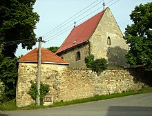
- St. Gallus Church, the early Gothic building from the 13th century was rebuilt in the 18th century.
- baroque bell tower, next to the church
- Statue of St. Adalbert, at the northern exit of the village, created in 1765
- sandstone prayer column on the village square, it originally carried a crucifix
- historical farms
- Memorial to the fallen of the First World War
Web links
Individual evidence
- ↑ Český statistický úřad - The population of the Czech municipalities as of January 1, 2019 (PDF; 7.4 MiB)


