Úmyslovice
| Úmyslovice | ||||
|---|---|---|---|---|
|
||||
| Basic data | ||||
| State : |
|
|||
| Region : | Středočeský kraj | |||
| District : | Nymburk | |||
| Area : | 623 ha | |||
| Geographic location : | 50 ° 12 ' N , 15 ° 10' E | |||
| Height: | 187 m nm | |||
| Residents : | 312 (Jan. 1, 2019) | |||
| Postal code : | 290 01 | |||
| License plate : | S. | |||
| traffic | ||||
| Street: | Pátek - Činěves | |||
| structure | ||||
| Status: | local community | |||
| Districts: | 2 | |||
| administration | ||||
| Mayor : | Jindřich Šimon (as of 2008) | |||
| Address: | Úmyslovice 58 290 01 Poděbrady |
|||
| Municipality number: | 537900 | |||
| Website : | www.umyslovice.wz.cz/umysl.html | |||
Úmyslovice (German Aumislowitz ) is a municipality in the Czech Republic. It is located ten kilometers northeast of Nymburk and belongs to the Okres Nymburk .
geography
Úmyslovice is located on a hill on the right side of the Blatnice on the East Bohemian Table. The Blato meadows are south of the village. To the east, the state road 32 passes between Poděbrady and Jičín .
Neighboring towns are Černá Hora in the north, Činěves and Velenice in the northeast, Podmoky in the east, Senice in the southeast, Ostrov and Blato in the south, Kouty in the southwest, Rašovice in the west and Netřebice , Šumbor and Vestec in the northwest.
history
Archaeological finds show that the area of the village was populated as early as the 3rd and 2nd centuries. On the hill south of the village, an urn burial field was found when a clay pit was being built. Further bones found at a depth of 40–50 cm were made in 1926 when the road to Podmoky was being built .
The place was first mentioned in writing in 1291 in the feudal book of the Poděbrady domain . There is evidence of a pastor since 1402. The village was destroyed during the Hussite Wars and then rebuilt. Around 1450, the owner of the estate, Georg von Podiebrad , had the Sánský kanál built as a water supply for the Podiebrad fish ponds, which created the largest pond in Bohemia south of Úmyslovice, the Bláto. To the west was the 558,302 m² pond Šumbor and on the northern edge of the village the Oumyslovice pond. Several legends later emerged about the king's visit in 1461 and an excursion to Bláto that he undertook; one of them says that George of Podebrady is said to have founded the village of Úmyslovice.
In 1553 Oumyslovice consisted of nine estates. In 1576 began the enlargement of the Oumyslovice pond to the whole valley between Oumyslovice, Netřebice and Činěves as well as the creation of a side canal from the Sánský canal at Odřepsy . For the pond construction Rudolf II had 15 property belonging to Dorota Křinecký expropriated, which only remained her manor. The pond construction was completed in 1586. From 1642 the place Oumyslovice, consisting of six farmers and three residents, was one of the school villages of the Podebrady rule, whose district also included Netřebice, Kouty, Velenice and Činěves. At the end of the Thirty Years War the Swedes burned the village down. Oumyslovice remained desolate for a long time and the parish became extinct. After the reconstruction of the place Oumyslovice was first parish to Poděbrady and from 1714 to Činěves. In 1777 the village of Laubenthal was created in the course of the raabization .
In 1787 the church was repaired and from that time on it was given the status of a locality. In the same year the Oumyslovice pond and the Šumbor were drained and the land was leased.
After the abolition of patrimonial Aumyslovice formed a municipality in the Poděbrady district from 1850. Between 1855 and 1856, the Šumbor farm was built northwest of the village. In 1858 the parish was re-established. The Šumbor farm was bought in 1883 by the sugar manufacturer Wiesner from Libice . In 1909 the new cemetery was laid out. On January 1, 1961 Úmyslovice came to Okres Nymburk, at the same time Ostrov was incorporated with Blato. Between 1980 and 1990 Kouty and Netřebice were also incorporated.
Community structure
The municipality Úmyslovice consists of the districts Ostrov ( Laubenthal ) and Úmyslovice ( Aumislowitz ) as well as the single layer Blato.
Attractions
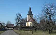
- Church of St. Leonhard, the structure built from plans and bricks, was built between 1729 and 1732 instead of a previous building. In 1819 it received an organ and in 1858 it was elevated to a parish church. The grave of the French stenographer Jean Coulon de Thévenot, who died in Schabata in 1813, is located in the old cemetery by the church .
- baroque statue in Ostrov
Sons and daughters of the church
- Alén Diviš (1900–1956), painter and illustrator, born in Blato


