Budiměřice
| Budiměřice | ||||
|---|---|---|---|---|
|
||||
| Basic data | ||||
| State : |
|
|||
| Region : | Středočeský kraj | |||
| District : | Nymburk | |||
| Area : | 801 ha | |||
| Geographic location : | 50 ° 12 ' N , 15 ° 6' E | |||
| Height: | 187 m nm | |||
| Residents : | 659 (Jan. 1, 2019) | |||
| Postal code : | 288 02 | |||
| License plate : | S. | |||
| traffic | ||||
| Street: | Nymburk - Netřebice | |||
| structure | ||||
| Status: | local community | |||
| Districts: | 1 | |||
| administration | ||||
| Mayor : | Marek Merhout (as of 2016) | |||
| Address: | Budiměřice 7 288 02 Nymburk 2 |
|||
| Municipality number: | 537055 | |||
| Website : | www.budimerice.cz | |||
Budiměřice (German Budimierschitz , also Budimeritz ) is a municipality in the Czech Republic. It is four kilometers east of Nymburk and belongs to the Okres Nymburk .
geography
Budiměřice is located on the left bank of Mrlina on the East Bohemian Table. The Sánský kanál runs south of the village , behind which lies the desert castle Buštěhrad.
Neighboring towns are Šlotava in the north, Rašovice in the northeast, Kouty in the east, Křečkov in the southeast, Velké Zboží and Poděbradka in the south, Kovanice and Zálabí in the southwest, Nymburk in the west and Kovansko in the northwest.
history
The first written mention of the village and the parish church was in 1374. Budiměřice was destroyed in the Hussite Wars .
After the abolition of patrimonial Budiměřice formed a municipality in the Poděbrady district with the district Borek from 1850 . In 1930 the Sánský kanál from Křečkov received a new course and was directed to the Mrlina . In 1930 the mouth of the Sánský kanál was moved from the Elbe to the Mrlina, and since then the canal has ended west of Budiměřice. In 1934 the community came to Okres Nymburk. In 1980 Rašovice and Šlotava were incorporated.
Community structure
For the municipality Budiměřice consists of the districts Budiměřice ( Budimierschitz ), Rašovice ( Raschowitz ) and Šlotava ( Schlotawa ).
Attractions
- Sánský kanál , technical monument
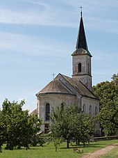
- Church of St. Prokop, built 1879–1881 in neo-renaissance style instead of a previous building
- Remains of the Buštěhrad fortress, the structure built in the 13th century fell into desolation in the 14th century.


