
Röttenbach (near Erlangen)
| coat of arms | Germany map | |
|---|---|---|

|
Coordinates: 49 ° 40 ' N , 10 ° 56' E |
|
| Basic data | ||
| State : | Bavaria | |
| Administrative region : | Middle Franconia | |
| County : | Erlangen-Höchstadt | |
| Height : | 301 m above sea level NHN | |
| Area : | 7.76 km 2 | |
| Residents: | 4750 (Dec. 31, 2019) | |
| Population density : | 613 inhabitants per km 2 | |
| Postal code : | 91341 | |
| Area code : | 09195 | |
| License plate : | ERH, HÖS | |
| Community key : | 09 5 72 149 | |
| Community structure: | 1 community part | |
| Address of the municipal administration: |
Ringstrasse 46 91341 Röttenbach |
|
| Website : | ||
| Mayor : | Ludwig Wahl ( FW ) | |
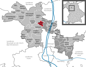
| Location of the municipality of Röttenbach in the Erlangen-Höchstadt district | ||
  |
||


Röttenbach is a municipality in the district of Erlangen-Höchstadt in Central Franconia .
The community is a preferred residential area for commuters to Erlangen .
geography
location
The community is north of Erlangen .
Community structure
The community consists only of the district and the district Röttenbach.
The municipal area, the places were Reihendorf and Weihermühle , both now abandoned settlements .
Neighboring communities
The neighboring communities of Röttenbach are Adelsdorf , Baiersdorf , Heßdorf and Hemhofen .
history
middle Ages
In 1177 the place was first mentioned in a document as "Rotenbach". The place name is derived from an identical water body name, the defining word of which is the adjective red; So reference is made to the reddish color of this brook. From the 10th century onwards, the basic word –bach in water names replaced the previously common basic word –aha . According to this, it can be assumed that around the year 1000 settlers came looking for land in the wooded, hilly landscape that forms the foothills of the Steigerwald . They settled this valley down, cleared parts of the forest and made the land arable . Wide swamp areas on the impermeable beds of the Keuperstufe allowed only poorly productive agriculture. Over the centuries, the inhabitants cultivated the swamps, the many chains of ponds were created that divided the forests and strive towards Röttenbach from the north, east and west, some of which still run through today.
In the 13th century a line of Truchseß von Pommersfelden , later called Truchseß von Röttenbach, took possession of the area. Sales deeds prove that farms and estates changed hands several times. In 1322 one estate went to the abbot of Michaelsberg Monastery , and in 1329 another to the bailiff at Nuremberg Castle . In 1476 the Bamberg monastery sold its farm to Christoph Truchseß in Röttenbach.
The main courtyard of the village, from which the later manor arose, was first mentioned in 1433 in a Bamberg fiefdom letter for Peter and Veit Truchseß. A castle was built on this farm , today the Sauer Brewery , which was secured with a moat. Insurgent farmers burned the castle down in the Peasants' War in 1525. The house, which was rebuilt later, has been preserved to this day, as has a finely crafted sandstone coat of arms from 1591 on the south wall of the brewery. In 1610 the property was pledged to the marshals of Pappenheim , who were related by marriage to Truchseß . In 1710 this fell to the Bamberg Monastery . Parts of the goods and subjects belonged to the imperial city of Nuremberg and the barons Winkler von Mohrenfels (Hemhofen). In the time of Napoleon Röttenbach was awarded the Crown of Prussia in 1803 , but in 1810, like a large part of Franconia, it came to the Kingdom of Bavaria .
Towards the end of the 18th century there were 68 properties in Röttenbach. The high court was exercised by the Bamberg center forchheim . The village and township government had the upper Bailiwick Office Forchheim held. The landlords were the bishopric Bamberg ( Kastenamt Forchheim (1 castle with brewery, 2 courtyards, 1 half courtyard, 2 estates, 2 estates, 3 houses, 1 fall house ), the Bamberg cathedral chapter (2 half estates, 4 estates), the St. Klara monastery in Bamberg (3 estates), the Nuremberg State Almosenamt (2 half yards, 9 estates), the Winklerische Herrschaft Hemhofen (1 mill, 3 half yards, 17 estates, 4 estates, 7 drip houses ) and the community of Röttenbach (church, 1 estate, 1 house)) .
As part of the municipal edict, the tax district Röttenbach was formed in 1811 , to which the towns of Hausen , Hemhofen , Oberheroldsbach , Reihendorf , Weihermühle and Zeckern belonged. With the Second Community Edict (1818), the Hemhofen Tax District, to which Zeckern belonged, was formed, and three rural communities were formed:
- Hausen with Oberheroldsbach,
- Hemhofen with Zeckern,
- Röttenbach with Reihendorf and Weihermühle.
The administration and jurisdiction of the municipality of Röttenbach was subordinate to the district court of Herzogenaurach and the financial administration to the Erlangen rent office . In voluntary jurisdiction, 33 properties were subordinate to the Neuenbürg Patrimonial Court (1820–1835). On October 1, 1847, the financial management was taken over by the Rentamt Herzogenaurach . From 1862 Röttenbach was administered by the district office of Höchstadt an der Aisch (renamed the district of Höchstadt an der Aisch in 1938 ) and continued to be administered by the rent office Herzogenaurach (1920–1929 tax office Herzogenaurach , from 1929: tax office Erlangen ). The jurisdiction remained with the district court of Herzogenaurach until 1879, 1880–1959 district court of Herzogenaurach , from 1959 district court of Erlangen .
present
Until the middle of the 20th century, most of the residents remained poor and were mostly day laborers . For many, a small additional income was the gathering of mushrooms and berries, "Butzeln" ( pine cones ), water lilies and sundew . They brought their goods, consisting mostly of natural products, to Erlangen and sold them there. Others drove through southern Germany, Switzerland and Austria and sold horseradish, which is famous for the region . In the difficult years after the Second World War, this merchant spirit formed the basis for an unexpected economic rise. The crouched farmhouses in the Franconian half-timbered style disappeared and were replaced by modern houses. Only the forester's house with half-timbered barn and shed and the rectory, both in baroque style, have been preserved as historically valuable buildings .
In 1972, the municipality of Röttenbach came from Upper Franconia to Middle Franconia as part of the regional reform , and most of the Röttenbach residents flocked there. In return, more and more new residents from the metropolitan region of Nuremberg- Erlangen-Fürth came to the village, which was still tranquil at the time. Röttenbach grew rapidly and took on its present form. In 1980 the brief administrative community with Hemhofen was dissolved again.
In January 2016, Röttenbach was officially recognized as a fair trade community for its longstanding commitment to fair trade .
Population development
| year | 1818 | 1840 | 1855 | 1861 | 1867 | 1871 | 1875 | 1880 | 1885 | 1890 | 1895 | 1900 | 1905 | 1910 | 1919 | 1925 | 1933 | 1939 | 1946 | 1950 | 1961 | 1970 | 1987 | 2005 | 2013 | 2017 |
|---|---|---|---|---|---|---|---|---|---|---|---|---|---|---|---|---|---|---|---|---|---|---|---|---|---|---|
| Residents | 519 | 743 | 725 | 674 | 738 | 737 | 666 | 717 | 719 | 698 | 699 | 743 | 788 | 759 | 846 | 858 | 960 | 976 | 1431 | 1478 | 1592 | 2040 | 3904 | 4654 | 4600 | 4726 |
| Houses | 85 | 121 | 122 | 133 | 151 | 217 | 308 | 994 | 1387 | |||||||||||||||||
| source |

politics
Municipal council
The town council of Röttenbach has 16 members, plus the full-time mayor.
| CSU | SPD | Free Voters Röttenbach eV (FW) |
Green | Independent Röttenbacher (UR) |
total | |
| 2008 | 4 seats | 5 seats | 5 seats | - | 2 seats | 16 seats |
| 2014 | 4 seats | 4 seats | 8 seats | - | - | 16 seats |
| 2020 | 4 seats | 2 seats | 8 seats | 2 seats | - | 16 seats |
(Status: local election on March 15, 2020 )
badges and flags
The municipality of Röttenbach has had a coat of arms since 1980.
|
|
Blazon : "Above a shortened and looped blue tip, in it a golden carp, split , in front a red Mauritius cross in silver, behind in silver a gold-armored and gold-crowned blue lion, covered with two red bars, breaking out of the edge of the shield."
Blue-yellow-red municipal flag |
| Justification for the coat of arms: The lion with two bars from the coat of arms of the Truchsessen of Pommersfelden reminds of the long connection between this family and the place. The Mauritius cross stands for the Röttenbach parish church. The carp refers to the carp farming in the municipality in the Aischgrund. |
Culture and sights
Architectural monuments
regional customs
The Röttenbach song
Röttenbach you are in beautiful Franconia
who knows you is banned by your charm.
Large forests frame your chains of ponds
, everyone can live and be content here.
Everyone can live and be satisfied here.
Where the gorse blooms so yellow on the edge of the forest,
Our ancestors struggled with it,
their brooms made Röttenbach known.
We are called broom binders in town and country.
We are called broom binders in town and country
Röttenbachers always went out into the world, they turned
full
humpback baskets into money. In the past it was Weiherhenkeli and Kre,
today it's garden flowers and health tea, today it's garden flowers and health tea
.
Nowadays Röttenbach is a proud place,
anyone who lived here for a long time was reluctant to move away.
Many new people built their houses here,
she moved out of the narrow city to us,
she moved out of the narrow city to us
We want to go into the future together,
as neighbors and friends stand together.
Everyone feels at home here, from big to small,
Röttenbach can be an expensive home for everyone,
Röttenbach can be an expensive home for everyone.
nature
Röttenbach is part of the Franconian sand axis and has numerous small patches of poor grassland, sand fields and dry forest edges that serve as a habitat for numerous specialized animals. A distinctive part of the Röttenbach area are also the many chains of ponds.
Pond
As part of the Aischgrund , Röttenbach is characterized by many ponds and ponds. These were laid out 500 to 700 years ago and still form the characteristic pond chains today. Pond management, especially carp farming, has a long tradition and is an important economic and cultural factor.
The many chains of ponds in the entire Aischgrund ensure a spacious biotope network. They form the habitat for many rare animal and plant species, such as the common moss damsel and the moor frog . In addition, the ponds regulate the water cycle as reservoirs by retaining water in the period of low precipitation and reducing runoff during flooding.
education
In Röttenbach there are two nursery schools (in Catholic or Protestant Church) with cribs offer and a primary school are taught in all classes. Professional lunch care is offered. There are also plans to build a new kindergarten on the primary school's soccer field.
The community also has its own library.
economy
traffic
The national road 2259 runs north over Hemhofen and Zeckern to national road 470 or south to Dechsendorf to State Street 2240 , the west one kilometer to the junction 81 of the A 3 leads. The district road ERH 5 leads west to Baiersdorf .
The VGN bus lines 205 and 246 also stop in Röttenbach .
The Franconian Marienweg runs through the village .
communication
Since the end of 2007 DSL has been available in the entire municipality with speeds of 6 to 16 Mbit / s. In 2013 the DSLAMs were supplied with new glass fibers. This makes it possible to gradually increase the download speed to up to 100 Mbit / s within 2 years.
literature
- Ingomar Bog : Forchheim (= Historical Atlas of Bavaria, part of Franconia . I, 5). Komm. Für Bayerische Landesgeschichte, Munich 1955, DNB 450540367 , p. 80 ( digitized version ).
- Johann Kaspar Bundschuh : Röttenbach . In: Geographical Statistical-Topographical Lexicon of Franconia . tape 4 : Ni-R . Verlag der Stettinische Buchhandlung, Ulm 1801, DNB 790364301 , OCLC 833753101 , Sp. 575 ( digitized version ).
- Georg Daßler (Ed.): District of Höchstadt ad Aisch. Past and present . Verl. F. Authorities and Wirtschaft Hoeppner, Aßling-Munich 1970, DNB 457004320 , p. 117-119 .
- August Gebeßler : City and district of Erlangen (= Bavarian art monuments . Volume 14 ). Deutscher Kunstverlag, Munich 1962, DNB 451450949 , p. 141 .
- Hanns Hubert Hofmann : Höchstadt-Herzogenaurach (= Historical Atlas of Bavaria, part Franconia . I, 1). Commission for Bavarian State History, Munich 1951, DNB 452071143 , p. 147 ( digitized version ).
- Franz Krug (ed.): The district of Erlangen-Höchstadt . Publishing house for authorities a. Wirtschaft, Hof (Saale) 1979, ISBN 3-921603-00-5 , p. 163-164 .
- Wolf-Armin von Reitzenstein : Lexicon of Franconian place names. Origin and meaning . Upper Franconia, Middle Franconia, Lower Franconia. CH Beck, Munich 2009, ISBN 978-3-406-59131-0 , p. 192 .
Web links
- Website of the municipality of Röttenbach
- Röttenbach in the Topographia Franconiae of the University of Würzburg , accessed on September 27, 2019.
- Röttenbach (near Erlangen): Official statistics of the LfStat
Individual evidence
- ↑ "Data 2" sheet, Statistical Report A1200C 202041 Population of the municipalities, districts and administrative districts 1st quarter 2020 (population based on the 2011 census) ( help ).
- ^ Community Röttenbach in the local database of the Bavarian State Library Online . Bayerische Staatsbibliothek, accessed on September 27, 2019.
- ↑ W.-A. v. Reitzenstein, p. 192.
- ↑ F. Krug (Ed.), P. 163f. = G. Daßler (Ed.), Pp. 117ff.
- ↑ I. Bog, p. 59.
- ^ Address and statistical manual for the Rezatkreis in the Kingdom of Baiern . Buchdruckerei Chancellery, Ansbach 1820, p. 49 ( digitized version ).
- ^ HH Hofmann, p. 147.
- ↑ nordbayern.de, Nuremberg, Germany: Röttenbach is allowed to call itself a “fair trade community” - Höchstadt - nordbayern.de. Retrieved May 15, 2017 .
- ↑ Only inhabited houses are given. In 1818 these were referred to as fireplaces , 1840, 1852 as houses , and from 1871 to 2017 as residential buildings.
- ↑ Alphabetical index of all the localities contained in the Rezatkkreis according to its constitution by the newest organization: with indication of a. the tax districts, b. Judicial Districts, c. Rent offices in which they are located, then several other statistical notes . Ansbach 1818, p. 77 ( digitized version ). Including the number of residents and fireplaces of Reihendorf (p. 75) and Weihermühle (p. 101).
- ↑ a b c d e f g h i j k l m Bavarian State Statistical Office (Hrsg.): Historical municipality register: The population of the municipalities of Bavaria from 1840 to 1952 (= contributions to Statistics Bavaria . Issue 192). Munich 1954, DNB 451478568 , p. 146 , urn : nbn: de: bvb: 12-bsb00066439-3 ( digitized version ).
- ^ Joseph Heyberger, Chr. Schmitt, v. Wachter: Topographical-statistical manual of the Kingdom of Bavaria with an alphabetical local dictionary . In: K. Bayer. Statistical Bureau (Ed.): Bavaria. Regional and folklore of the Kingdom of Bavaria . tape 5 . Literary and artistic establishment of the JG Cotta'schen Buchhandlung, Munich 1867, Sp. 878 , urn : nbn: de: bvb: 12-bsb10374496-4 ( digitized ).
- ↑ Kgl. Statistical Bureau (ed.): Complete list of localities of the Kingdom of Bavaria. According to districts, administrative districts, court districts and municipalities, including parish, school and post office affiliation ... with an alphabetical general register containing the population according to the results of the census of December 1, 1875 . Adolf Ackermann, Munich 1877, 2nd section (population figures from 1871, cattle figures from 1873), Sp. 1051 , urn : nbn: de: bvb: 12-bsb00052489-4 ( digitized ).
- ↑ K. Bayer. Statistical Bureau (Ed.): Localities directory of the Kingdom of Bavaria. According to government districts, administrative districts, ... then with an alphabetical register of locations, including the property and the responsible administrative district for each location. LIV. Issue of the contributions to the statistics of the Kingdom of Bavaria. Munich 1888, Section III, Sp. 996 ( digitized version ).
- ↑ K. Bayer. Statistical Bureau (Ed.): Directory of localities of the Kingdom of Bavaria, with alphabetical register of places . LXV. Issue of the contributions to the statistics of the Kingdom of Bavaria. Munich 1904, Section II, Sp. 1044 ( digitized version ).
- ↑ Bavarian State Statistical Office (ed.): Localities directory for the Free State of Bavaria according to the census of June 16, 1925 and the territorial status of January 1, 1928 . Issue 109 of the articles on Bavaria's statistics. Munich 1928, Section II, Sp. 1078 ( digitized version ).
- ↑ Bavarian State Statistical Office (ed.): Official place directory for Bavaria - edited on the basis of the census of September 13, 1950 . Issue 169 of the articles on Bavaria's statistics. Munich 1952, DNB 453660975 , Section II, Sp. 925 ( digitized version ).
- ↑ Bavarian State Statistical Office (ed.): Official city directory for Bavaria, territorial status on October 1, 1964 with statistical information from the 1961 census . Issue 260 of the articles on Bavaria's statistics. Munich 1964, DNB 453660959 , Section II, Sp. 681 ( digitized version ).
- ^ Bavarian State Statistical Office (ed.): Official place directory for Bavaria . Issue 335 of the articles on Bavaria's statistics. Munich 1973, DNB 740801384 , p. 173 ( digitized version ).
- ↑ Bavarian State Office for Statistics and Data Processing (Ed.): Official local directory for Bavaria, territorial status: May 25, 1987 . Issue 450 of the articles on Bavaria's statistics. Munich November 1991, DNB 94240937X , p. 335 ( digitized version ).
- ↑ a b c LfStat : Röttenbach: Official statistics. In: statistik.bayern.de. Pp. 6 and 12 , accessed on October 26, 2019 .
- ^ Entry on the coat of arms of Röttenbach (near Erlangen) in the database of the House of Bavarian History
- ↑ Röttenbach. In: Kommunalflaggen.eu. Retrieved July 4, 2020 .
- ↑ Archived copy ( memento of the original dated February 23, 2014 in the Internet Archive ) Info: The archive link was inserted automatically and has not yet been checked. Please check the original and archive link according to the instructions and then remove this notice.
- ^ Sand axis Franconia: project areas
- ↑ https://www.roettenbach-erh.de/karpfenfuhrer/geschichte/karpfenfuhrer/
- ↑ Archived copy ( Memento of the original from August 28, 2016 in the Internet Archive ) Info: The archive link was inserted automatically and has not yet been checked. Please check the original and archive link according to the instructions and then remove this notice.
- ↑ Third day care center for Röttenbach: needs recognized. Retrieved July 17, 2019 .
- ^ Community of Röttenbach DSL expansion - 2013

Adelsdorf | Aurachtal | Baiersdorf | Bubenreuth | Buckenhof | Eckental | Gremsdorf | Großenseebach | Hemhofen | Heroldsberg | Herzogenaurach | Hessdorf | Höchstadt an der Aisch | Kalchreuth | Lonnerstadt | Marloffstein | Möhrendorf | Mulhouse | Oberreichenbach | Röttenbach | Savings Village | Uttenreuth | Vestenbergsgreuth | Wachenroth | Weisendorf
Unregulated areas in the district of Erlangen-Höchstadt
Birkach |
Buckenhofer Forest |
Dormitzer Forest |
Erlenstegen Forest |
Forest Tennenlohe |
Geschaidt |
Kalchreuther Forest |
Kraftshofer Forest |
Mark |
Neunhofer Forest